Beberibe Cliffs Natural Monument
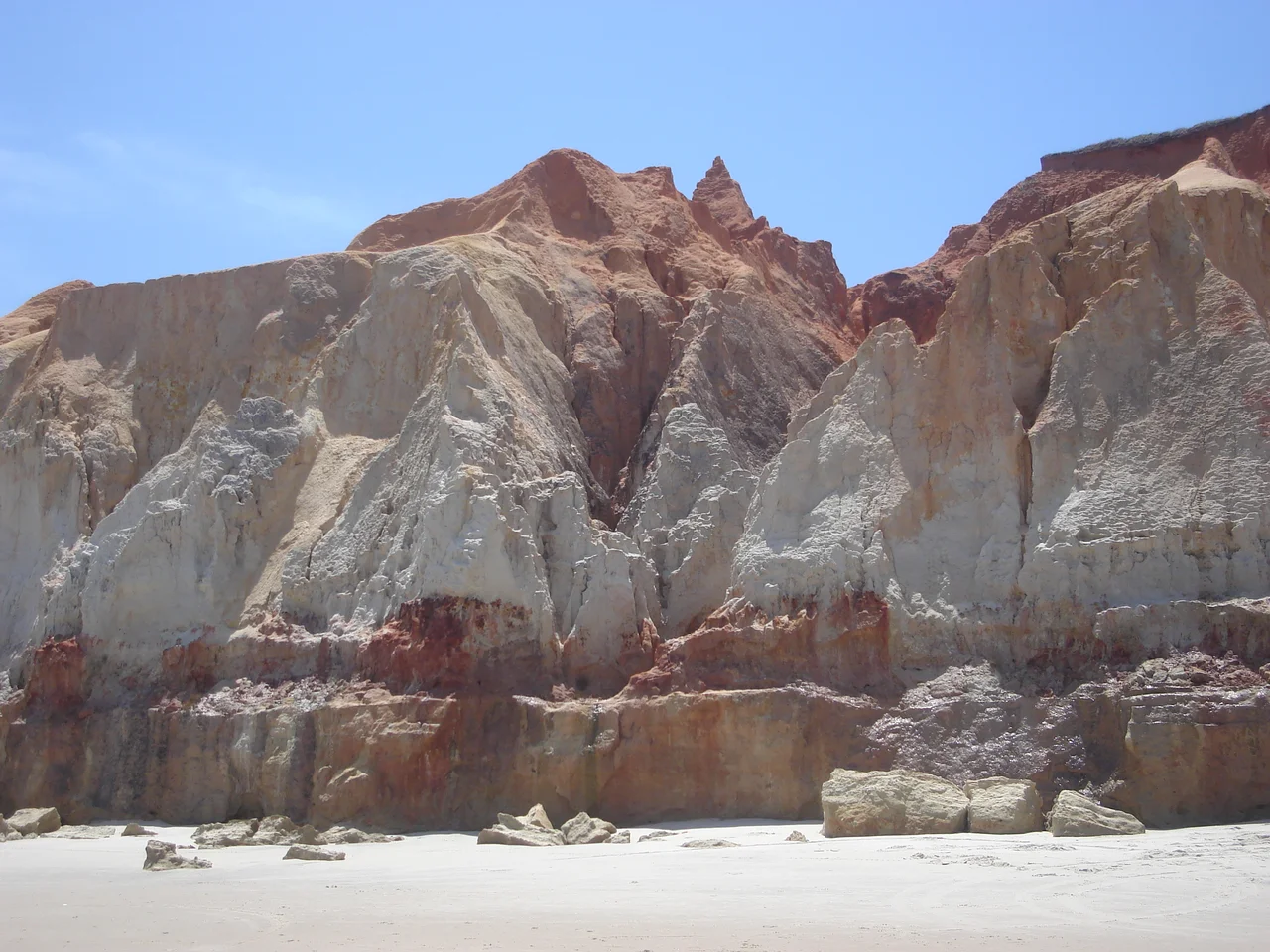
The cliffs are red, and then they are not. They are also white, yellow, ochre, cream, and every gradient in between - a stacked cake of sand-clay sediments laid down across the Tertiary and Quaternary ages, and now being slowly unwrapped by the Atlantic. For six kilometers along the Ceará coast between the beaches of Morro Branco and Fontes, the Barreiras tableland meets the sea and loses. Wind and wave have been carving this edge for millions of years. In 2004, Ceará drew a line around a small piece of it and called it a natural monument, hoping to slow down what the tourists were accelerating.
Seventeen Colors in a Bottle
The cliffs' most famous product is not a view but a souvenir. Local artisans, many of them working in studios cut into the cliff face itself, fill small glass bottles with the naturally colored sands they scrape from the exposed layers. The results look like miniature geology lessons - landscapes of camels, palm trees, and dune lines painted with nothing but sand, grain by grain, through the bottle's neck. Tradition counts seventeen distinct colors in the Beberibe palette. Whether that number is exact or folkloric, the range is real: iron oxides produce the reds, manganese tints the darker bands, quartz keeps the whites bright. A bottle of Beberibe sand is, quite literally, a slice of tropical Brazil compressed to the size of a coffee cup.
A Small Reserve for a Big Problem
The monument protects just 31.2 hectares along a 5,709-meter perimeter - a modest footprint for a site that receives around 400 visitors per day. The decree that Ceará governor Lúcio Alcântara signed on 3 June 2004 converted the area to full protection, barring everything but eco-tourism and research, requiring authorized guides, mandating interpretive signage, and promising employment for local youth. On the same day, the governor also created the Mata Fresca Private Ecological Reserve - a two-for-one environmental gesture. The protection mattered because the cliffs outside the reserve were rapidly being colonized by hotels and vacation homes. Within the monument, the sediments at least got a legal shield.
The Cave of the Water Mother
The most visited feature along this coast is not inside the protected area. It is the Gruta da Mãe D'Água - the Cave of the Water Mother - a wave-cut hollow in the cliffs at Fontes beach. Generations of erosion have carved it into a natural chamber, and generations of visitors have signed their names on its walls, climbed where climbing was unwise, and accelerated the very processes the cave's beauty depended on. The cave is now at risk of collapse. The monument was created too late and drawn too small to include it. The paradox is familiar: the feature people most want to see is the one they are hastening to destroy.
Geology in Motion
The cliffs are not static. The sea works on them from below, gullies carved by rainwater cut them from above, and the wind does the rest. The grains they shed become the beaches at their base. In a human timescale this is slow. In a geological timescale it is rapid - the Barreiras formation is young, the sea is close, and the whole structure is a temporary arrangement headed, eventually, back to the ocean. Environmental planners have proposed expanding the monument with a buffer zone, or encircling it with a larger Environmental Protection Area that would include Morro Branco and Fontes beaches. Whether that expansion comes before the colors reach the waves is, as always in these places, a race.
The Labyrinth
What the cliffs offer to a visitor who respects them is a walk through a labyrinth of color. The gullies form narrow corridors between cliff walls tall enough to throw the afternoon into shadow. The red walls rise above white sand. A stream trickles through. Around each turn the palette shifts - a band of ochre follows a band of cream, and the shape of the corridor opens into a room that closes back into a slot. You come out onto Morro Branco beach blinking, as if the rest of Brazil had suddenly turned the lights back on.
From the Air
The Beberibe Cliffs Natural Monument lies at 4.158°S, 38.108°W on the Atlantic coast of Ceará, approximately 80 km southeast of Fortaleza. The nearest airport is Pinto Martins International Airport (SBFZ) in Fortaleza. The cliffs themselves run for about 6 km along the coastline between Morro Branco and Fontes beaches - a distinctive red-and-white stripe visible from low-altitude approaches in clear conditions. Best viewing in the dry season (June-December) when haze is minimal.
Nearby Stories
- Redenção, Ceará 12 km away
- VASP Flight 168 24 km away
- Beach Park 27 km away
- Canoa Quebrada 52 km away
- Quixadá Monoliths Natural Monument 73 km away
- Furna Feia National Park 75 km away
- Mossoró 121 km away
- Atol das Rocas Biological Reserve 422 km away