Binnendieze
Listen, on a quiet morning in 's-Hertogenbosch, and you can hear water moving where there is no river. The sound comes up through grates in alley pavements, leaks out of arches at the base of houses, ripples briefly under a bridge where a street suddenly bends for no obvious reason. The Binnendieze is the city's underground river system - eight centuries of Dommel river quietly built over by the people who needed both the water and the space. It was almost lost in 1969. Two stubborn councilmen and a sketch sent up at the last minute from The Hague saved it. Today it is the strangest boat tour in the Netherlands.
How A River Disappears Under A City
Before 's-Hertogenbosch existed, the Dommel river simply flowed through the marsh, met the Aa at what is now Hinthamereinde, and continued west to the Meuse. Then in the early 1200s the first city wall went up, and the river found itself indoors. When the much larger second wall was built in the 14th century, more of the Dommel and several tributaries came inside too - the Verwerstroom where dyers and fullers worked their cloth, the Vughterstroom that fed the city harbor, the Kerkstroom flowing under a church choir, the Kleine Vughterstroom hidden in a long stone corridor called the Hellegat. The city dug new channels to connect them, blocked old ones, diverted streams to feed defensive moats, and then - inevitably, because real estate was always at a premium - the citizens began building over the top of everything. Houses extended on stone arches across the water. Streets jumped the channels. By the 17th century, much of the river network ran through what amounted to private basements.
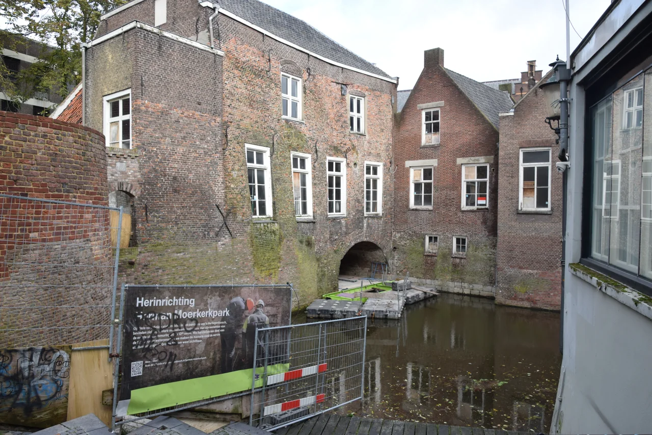
The Big Hekel
The water gate where the river enters the old city is called Groote Hekel - from hekel, the heavy beams that could drop down to seal a gate. It was first mentioned in 1399 and originally had three openings, not two; locals knew it as De Drie Hekelen, the three gates. The westernmost was bricked up from 1634 to 1668 to keep more water in the militarily critical Bossche Broek marshes south of the city, which the defenders could flood at will to keep besieging armies away. Before 1880 the medieval gates could stop enemies but not the river itself. A double lock added to the outside that year fixed that. Today the medieval Hekel can only be seen from inside the walls - the locks block the view from the outside - and just east of it stand the ghostly remains of a steam pumping station built in the 1880s and torn down in 1965, when the city was getting ready to do something far worse to the river than steam ever did.
Dyers, Fullers, And A Place Called Hell-Hole
The street names along the Binnendieze read like a guild ledger. Verwerstraat (Dyers' Street), Volderstraatje (Fullers' Alley), Raamstraatje (Frame Alley, for the racks where wool was stretched to dry). Fulling was the dirty job of pounding woolen cloth in stale urine to felt it, and the Verwerstroom carried the runoff away. The Hellegat - literally hell-hole - is the long, completely dark covered stretch of the Kleine Vughterstroom. In 1966 the foundations of the provincial assembly room directly above the Hellegat collapsed, and panicked public servants scrambled to rescue documents and reduce the floor pressure that had given way. The fix was simple concrete. The river kept flowing under it, indifferent. The names that medieval workers attached to their stretches of water - Doode Stroom for the dead stream that stopped flowing, Kerkstroom for the one under the church - have outlasted every business that ever used them.
The Day The Council Voted Wrong
After the war, automobiles changed everything. In 1962 the city filled in the Marktroom and old moat without any real protest. Then in 1964 the council secretly drafted Structure plan 1964: motorways slicing through the center, 25 percent of historic buildings destroyed, the inner harbor filled in, the Binnendieze almost entirely erased. The plan was unveiled six days before the vote. Outrage exploded. The Comite Behoud Binnenstad (Committee to Preserve the Inner City) formed. The plan passed anyway. But in September 1966 two newcomers - Hein Berge and Jan van der Eerden - won council seats for a new party called Beter Bestuur (Better Government). They demanded to see an earlier report on the Binnendieze. It took the council 23 months to deliver one - and that report turned out to be newly written; the original had been suppressed. The new version recommended using the river as a route for the city's new sewer system and then filling it in. On the third day of the January 1969 debate, a sketch arrived from The Hague: the national heritage service was designating large parts of the Binnendieze as protected cityscape. The vote went the wrong way. The protection held anyway. By December 1972 the entire inner city was officially protected, and the council had quietly changed its mind.
The Boats Today
Climb into one of the flat-bottomed boats at the Vughterstroom dock and the experience is unlike any other waterway in the Netherlands. The boats are low and narrow because they have to be: stretches of the route pass through arches just centimeters above your head, then open into wider channels where geraniums hang from windowsills directly above the water. You glide beneath houses, alongside the back walls of restaurants, past the spot where the Verwerstroom abruptly turns west under the Postelstraat, through the long darkness of the Hellegat where you cannot see your own hand. The Noordbrabants Museum sits over its own stretch of the Verwerstroom. The choir of St. Catherine's Church straddles the Kerkstroom, preserved across three rebuildings because demolishing it would have meant demolishing the river too. The tour ends back in daylight at the inner harbor, and the city above looks ordinary again - until you start noticing the gratings.
From the Air
The Binnendieze runs through the historic center of 's-Hertogenbosch at 51.685 N, 5.308 E. From cruise altitude the river is invisible - it flows beneath the city - but the old fortified outline of Den Bosch is clearly visible, surrounded by the green of the Bossche Broek marsh to the south. Eindhoven Airport (EHEH) lies 18 nm south, Schiphol (EHAM) 50 nm north-northwest. The A2 and A59 motorways frame the city. Look for the Gothic spire of Sint-Janskathedraal as the visual anchor; the underground river network spreads out from there.
Nearby Stories
- Gelders Arcadië 2.2 km away
- Catharina Ziekenhuis 4.5 km away
- Grebbe Line 5.4 km away
- Woerden 6.6 km away
- Geertruidenberg Castle 8.7 km away
- Kleve 12 km away
- Hoogstraten Castle 15 km away
- Venlo 20 km away