Grebbe Line
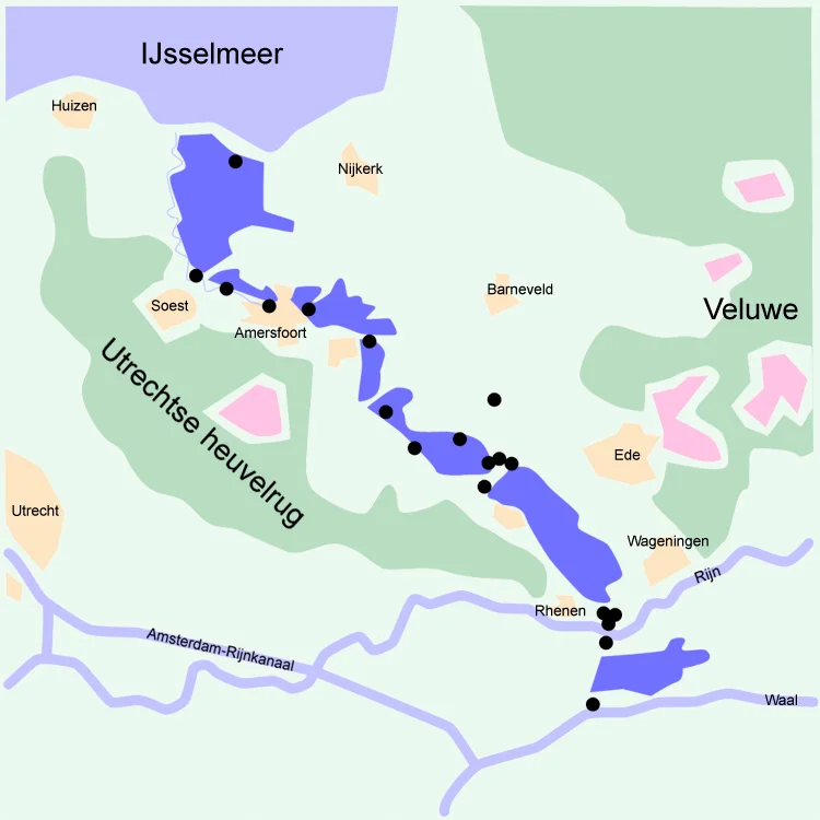
The Dutch had been winning wars with water for four hundred years before the Grebbe Line was first cut into the landscape in 1745. The doctrine was elegant: dig channels, build dikes that doubled as walls, and when an enemy approached, open the sluices and drown the polder. An army cannot march across a meter of water, and boats cannot float across ground that is only ankle-deep. The Grebbe Line ran from the Grebbeberg, a 150-foot ridge above the Rhine at Rhenen, northward to the IJsselmeer, sixty kilometers of inundation zones backed by trenches and concrete bunkers. The problem with the doctrine was simple and known: you cannot flood a hill. The Grebbeberg was the hill.
A Line Drawn and Forgotten
The original Grebbe Line was established in 1745 to protect the Netherlands from invading armies, with the area between Spakenburg and the Grebbeberg slated for flooding in case of attack. Through the late eighteenth century it sat unused. In 1794 the joint British-Dutch army tried to occupy the line against the advancing French army of General Jean-Charles Pichegru, but abandoned the position when the French approached. For the next century and a half the line was maintained without ever being tested, until in 1926, with no plausible threat in sight, the Dutch government decommissioned most of the fortifications. The country was about to learn that history has a way of returning to defensive infrastructure exactly when the engineers have stopped paying attention.
The Hasty Rearmament
In 1939, with German rearmament unmistakable, the Dutch began fortifying the disused line again. The plans were ambitious: dense concrete bunkers, deep trench systems, mutually supporting fields of fire, the whole apparatus held behind a wall of shallow water. The plans were also expensive, and a poor country emerging from the Depression could not afford to execute them. What was built by May 1940 was a thin front line, only half a battalion of infantry per kilometer, backed by a shallow second line and reserves further back. Three weak spots remained: two near Amersfoort and one at the Grebbeberg, where the elevation made flooding impossible. A bomb-proof pump house was under construction to flood the ground in front of the ridge, but it was not finished in time. The Germans, who had sent staff officers in civilian clothes to walk the line before the war, knew exactly where to push.
The Grebbeberg, May 1940
On 10 May 1940 German forces crossed the eastern border. By the second day the 207th Infantry Division, spearheaded by the motorized SS Regiment Der Fuhrer, had reached the Grebbeline near Rhenen. The SS regiment took all of the second day fighting through the forward defenses, with mounting losses. On the third day they penetrated the front line on the Grebbeberg itself, fighting through the evening to widen the breach. The Dutch held the third defensive line behind them. The 207th division commander pulled SS Der Fuhrer north and committed his own infantry. Overnight the Dutch organized a counterattack with four infantry battalions; the operation was poorly coordinated and collided directly with a renewed SS assault on the fourth day. German dive bombers tore apart both the Dutch counterattack and the defensive position. By evening the German infantry stood in the village of Rhenen. The cost: approximately 420 Dutch soldiers killed in action and 250 German, with roughly four times those numbers wounded. The Dutch lost thousands of prisoners of war and most of their artillery in the sector.
Scherpenzeel, the Bend in the Line
The other major battle on the Grebbeline came at Scherpenzeel, where the defenses turned a right angle. The 227th Infantry Division, having lost its SS reinforcements to a redeployment south, attacked the corner with two infantry regiments side by side. The geometry of the defense meant the attackers exposed themselves to fire from fixed trench positions and artillery along two thirds of their front and flank simultaneously. The German command had chosen the worst possible point to push. The attack collapsed with 70 dead, most from the 412th Regiment, and the wounded crawling back to their lines overnight. Dutch artillery laid a heavy barrage across the suspected German positions through the night, gradually thinning before dawn. The Germans, expecting heavy fighting in the morning, advanced cautiously into deserted trenches. Behind the cover of the barrage, the entire Dutch defense had withdrawn overnight to the next line. Pursuit came too late. It was the rarest of things in May 1940: a clean Dutch tactical victory, undone by the strategic collapse of the country as a whole.
What the Cemetery Holds
On top of the Grebbeberg, where the SS Der Fuhrer regiment had paid in lives to take the high ground, a war cemetery was established immediately after the surrender. German and Dutch dead were buried side by side at first, then the Germans expanded the burial ground as their occupation casualties mounted across the country. After the war the German dead were reinterred at Ysselsteyn, where more than 30,000 German war dead now lie in a single field of honor. The Grebbeberg cemetery now holds around 800 Dutch soldiers from the five days of May 1940, with a few later wartime burials. In October 1944, with the war turning against them, the Germans reused the same defensive geography to build their own Pantherstellung, this time facing south against the Allied advance from Arnhem; the configuration from Veenendaal to Amersfoort remained identical to the old Grebbe Line. The Dutch government permanently decommissioned the line in 1951. The trench scars, the bunkers, and the cemetery remain. The hill is still a hill, and water still flows around it.
From the Air
The Grebbeberg sits at 51.96 N, 5.59 E above the Rhine at Rhenen; the line runs north from there toward the IJsselmeer at Spakenburg, roughly 52.13 N, 5.42 E. The line itself follows the western edge of the Gelderse Vallei. The article's stored coordinates 52.08 N, 5.46 E place the focus on the central section of the line, halfway between Rhenen and Amersfoort. Nearest airfields: Lelystad (EHLE) 35 km north; Soesterberg (closed) 20 km west; Schiphol (EHAM) 60 km west. The terrain is unmistakable from altitude: the dark wooded ridge of the Veluwe to the east, the flat polder of the valley to the west, the Rhine bending east-west across the southern end.
Nearby Stories
- Willem I Lock 0.9 km away
- Battle of Woerden 3.3 km away
- Ter Horst Castle 3.6 km away
- Heerde 6.4 km away
- Flevopolder 8.2 km away
- Heesen Yachts 11 km away
- Kleve 13 km away
- De Biesbosch National Park 16 km away