Flevopolder
The largest artificial island on Earth is not in Dubai or Hong Kong harbor. It is in the middle of the Netherlands, it covers 970 square kilometers, and almost half a million people live on it without ever quite calling themselves islanders. The Flevopolder is bigger than Paris and Belo Horizonte combined. It holds three cities, a forest, a national park, and some of the most productive farmland in northern Europe. When you fly over central Holland and notice a perfectly rectangular landscape of fields stitched together with canals, that is the Flevopolder — a piece of the country that did not exist when most of its residents' grandparents were born.
Two Halves, Thirteen Years Apart
The polder came in two pieces. The dikes around Oostelijk Flevoland, the eastern half, closed in 1957, and the pumps ran for months until what had been seabed lay drained and silent on 28 June of that year. The southwestern half, Zuidelijk Flevoland, followed eleven years later. Its pumps finished in 1968. The land that emerged was clay laid down by the Zuiderzee over thousands of years, salty at first, drained through ditches, then sweetened by rain and freshwater pumping until crops could grow. By some definitions this counts as the largest artificial island in the world, because the Flevopolder is wholly surrounded by water: the IJsselmeer to the north, the Markermeer and Gooimeer to the west, the Veluwemeer and Ketelmeer to the east and south. The ring of bordering lakes was kept on purpose, to keep the water tables of the old shore from collapsing into the new low ground.
The Name From a Lost Sea
Flevo was the name the Romans used for a freshwater lake that once sat where the polder now lies. Over the centuries that lake grew, swallowed villages, and merged with the North Sea to become the Zuiderzee — a brackish inland sea that flooded cities like Amsterdam during the worst storms. Cornelis Lely, the hydraulic engineer who designed the closing of the Zuiderzee, wanted to undo that history. The Flevopolder was the centerpiece of his plan, and the province built on it was named Flevoland when it joined the Netherlands in 1986. It was the country's twelfth and newest province, occupying land that, when Lely first sketched it on paper in 1891, was still under several meters of salt water.
Three Cities From Scratch
Building empty land is one thing; convincing people to live on it is another. The Dutch built three cities to do the convincing. Lelystad came first, founded in 1967 on the eastern polder and named for the engineer himself. Dronten and the smaller agricultural towns followed in the 1960s and 1970s. Then, in 1976, came Almere on the southwestern polder, planned as a new town to take overflow from Amsterdam. Almere grew faster than anyone predicted. It is now the eighth largest city in the Netherlands, with more than 220,000 residents, on land that was sea floor when its earliest immigrants were born. The Flevopolder's three settlements together hold around four hundred thousand people, living lives that depend completely on the dikes and the pumping stations that keep them dry.
A Country That Sinks
The polder rests roughly four to five meters below the surrounding lakes. Walk along the Knardijk or the Oostvaardersdijk and you can look up at sailboats riding past at the level of your eyes. The land itself is still settling. Clay compresses as it dries, peat oxidizes once exposed to air, and the polder has subsided by more than a meter in places since 1957. Engineers expected this and built it into the plans, but the slow sinking concentrates the mind. Every drain, every pumping station, every kilometer of dike is part of an active system. There is no version of this landscape that runs itself. The Flevopolder is the Netherlands at its most explicit: a country built by argument, by ledger book, by engineer, and held against the water by daily attention. It is a quiet place, mostly flat fields and reed margins, and if you did not know its history you might never guess it. But the history is the point. The Flevopolder is what humans can do in a single century when they decide they need more land than they were born with.
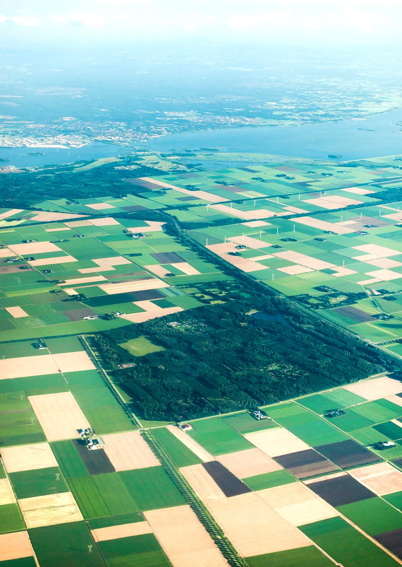
From the Air
Centered around 52.45°N, 5.50°E, with the polder extending roughly from 52.30°N to 52.70°N and from 5.20°E to 5.85°E. The whole landmass sits 4 to 5 meters below sea level, surrounded by the IJsselmeer, Markermeer, Veluwemeer, Ketelmeer, and Gooimeer. From cruising altitude the polder is unmistakable: a vast rectangle of geometric farm plots, woodland blocks, and the three cities (Almere southwest, Lelystad center-north, Dronten east) connected by the A6 motorway. Lelystad Airport (EHLE) is the only airfield on the polder; Schiphol (EHAM) is 30 to 50 km southwest depending on which corner you cross.
Nearby Stories
- Zaanstreek-Waterland 0.5 km away
- Veluwsche Stoomtrein Maatschappij 5.3 km away
- Hattem 6.3 km away
- Giethoorn 6.8 km away
- Onze Lieve Vrouwetoren 7.2 km away
- Windpark Noordoostpolder 10 km away
- Battle of Woerden 13 km away
- Battle of Krabbendam 14 km away