Onze Lieve Vrouwetoren
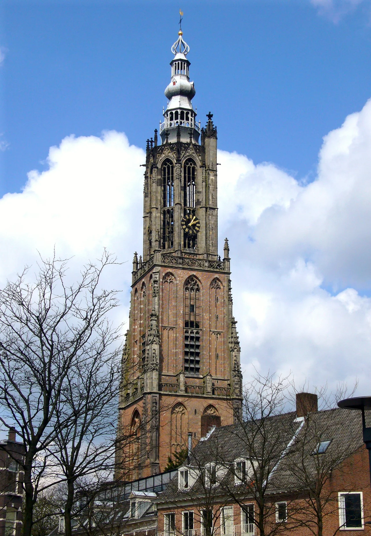
Every map of the Netherlands is anchored to this spot. Pull out a Dutch land registry plan, a survey marker, a cadastral grid, and trace its coordinates back to the source: a brick steeple in Amersfoort that has stood since the 1470s and lost its church to gunpowder more than two centuries ago. Locals call it Lange Jan - Long John - which is the kind of nickname you give to something both beloved and slightly absurd. At 98.33 metres it is the third-tallest church tower in the country, but its real distinction is mathematical. For roughly a century, the centre of the Dutch national grid sat at the spire's tip, and the coordinates surveyors still use today are named for the city below it.
A Tower Without a Church
Walk into the square on a summer afternoon and look at the cobblestones. Set into the pavement, in pale stone, is the outline of a building that no longer exists - the nave, the aisles, the choir of the Gothic church that Lange Jan was once attached to. The original chapel went up here in the 14th century. By the 15th, a three-aisled church had replaced it, and somewhere around 1444 work began on the tower; construction wrapped up around 1470. The Reformation came hard to this part of Holland. In 1579 Protestants seized the building during the iconoclastic furies and burned the construction archives, which is why the start date is approximate rather than precise. Then in the 18th century, a gunpowder explosion at what had been repurposed as a munitions store and shell laboratory blew the church apart - sparing the steeple. The tower stood. The church did not. Today only its footprint, etched in stone, remains.
The Origin of Dutch Coordinates
Between 1885 and 1904, Dutch surveyors built a national reference system known as the Rijksdriehoeksstelsel - the State Triangulation System. They needed a starting point: somewhere central, stable, and high enough to sight from. They chose the spire of Lange Jan. From that point, x equalled zero and y equalled zero. Every map, every property line, every cadastral document in the country was measured from this brick column rising over Amersfoort. The arrangement worked, but it had a quirk - the system produced negative coordinates west and south of the tower, and the x and y values could be confused with each other. So between 1960 and 1978 the zero was relocated, mathematically rather than physically, by sliding the origin 155 kilometres west and 463 kilometres south, to a quiet patch of countryside southeast of Paris near La Celle-Saint-Cyr. The tower kept its job. The new coordinates of Lange Jan became, neatly, X = 155,000 and Y = 463,000. The Dutch grid still bears Amersfoort's name.
The Twelve Faces on the Tower
During the restoration of 1993 to 1996, sculptor Ton Mooy replaced the weathered consoles - the carved stone brackets that ring the tower - with twelve new figures. Mooy used Volvic basalt lava rather than the soft tuff stone of the earlier carvings; health regulations had ruled out the original Bentheim sandstone, and the volcanic basalt could be cut more finely and would weather the North Sea winds better. The faces are a memory book of the town. Hendrik van Vianden, the Bishop of Utrecht who granted Amersfoort its city rights in 1259, looks out from one bracket. Margriete Gijsen, who in 1444 found the miraculous statue of Mary in the canal near the Kamperpoort - the find that started the pilgrimage that paid for the church - is carved on another. David of Burgundy, the bishop in office when the tower itself rose, gets his portrait. So does Leendert Nicasius, the city carpenter who in 1651 climbed the burning spire after a lightning strike and saved the structure. The bricklayer, the blacksmith, the weaver, the brewer, the monk, the stonecutter - the trades that built medieval Amersfoort - stand alongside the bishops.
Burned, Restored, Repurposed
The spire has been lost twice. In 1651 lightning ignited it and Nicasius and his crew kept the body of the tower from coming down. In 1804 it burned again. The current pinnacle is a restoration, careful but not original. The tower has been worked on three times in the modern era - 1912 to 1932, 1965 to 1970, and the carving project of 1993 to 1996 - and after the church around it was demolished, the structure spent a strange middle life as a powder magazine and a place where artillery shells were assembled. A medieval steeple housing the manufacture of munitions is not a use the original builders imagined, but Lange Jan has always been a survivor.
Lange Jan from the Air
From above, the tower is unmistakable: a slender brick spike rising abruptly out of the tight red-tiled roofs of Amersfoort's old town, with the green of the Eemland flatlands rolling away to the north and the wooded ridges of the Utrechtse Heuvelrug just beyond. Drop the geographic coordinates of this point into any Dutch GPS app and you will see how strangely central Amersfoort sits in its own country - which, given the history, is no accident. The Dutch chose this place because it was central. The country, in a sense, was measured from here.
From the Air
Coordinates: 52.1552°N, 5.3872°E. Tower height 98.33 m above ground level (roughly 320 ft). Located in the old centre of Amersfoort, Utrecht province. From the air the spire stands clear of the surrounding rooftops and aligns visually with the Eem river just north. Nearest airports: Schiphol (EHAM) about 45 km west; Lelystad (EHLE) about 30 km north. Note the dense urban traffic patterns around Schiphol and the active airspace north toward Hilversum.
Nearby Stories
- Willem I Lock 0.9 km away
- Battle of Woerden 3.3 km away
- Ter Horst Castle 3.6 km away
- Heerde 6.4 km away
- Flevopolder 8.2 km away
- Heesen Yachts 11 km away
- Kleve 13 km away
- De Biesbosch National Park 16 km away