
Blackall, Queensland
Somewhere past the Blackall State School, behind a low fence on Thistle Street, sits a charred remnant of timber that Australians have spent a century arguing about. Surveyors planted an astronomical station near here in the late 1880s, sighting their transit instruments to fix latitude and longitude across the vast emptiness of central-west Queensland. To everyone living on the Barcoo, the country that began where the survey ended was simply 'beyond the black stump' - past the last reliable point on the map, out where the channels run inland and the homesteads thin to nothing. Blackall claims to be the home of that stump. Other towns claim it too. But Blackall has the survey, the signage, and the swagger, and on the high plains, swagger counts for a great deal.
The Man Who Shore 321
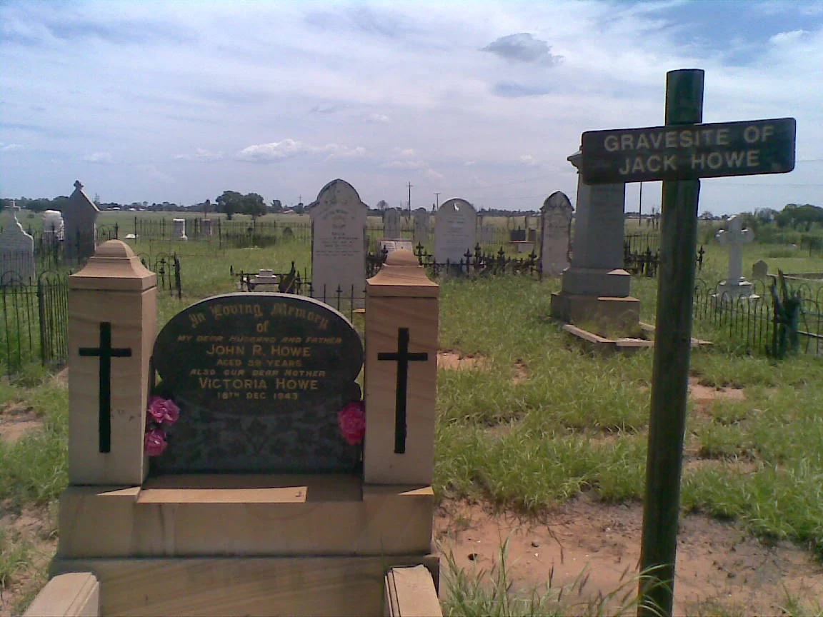
On 10 October 1892, at Alice Downs station just outside town, a broad-shouldered shearer named Jackie Howe bent over the boards and did not straighten until he had shorn 321 sheep. It took him seven hours and forty minutes, blade shears in hand - no machine, no motor, just steel, sweat, and a rhythm that has never been equalled by hand. The record still stands. It was not beaten until 1950, and only then by a man using a powered handpiece. Howe was born on Canning Downs near Warwick and died at Blackall in 1920; he lies in the town cemetery. The navy singlet that working Australians still pull on every morning carries his name, after the cut-down shirt he is said to have worn the day he made history.
Water from a Mile Down
In 1885, Blackall did something audacious for a frontier town: it drilled for water it could not see. The bore struck the Great Artesian Basin, that immense sea of ancient water trapped beneath two-thirds of Queensland, and what came up was hot - 58 degrees Celsius, straight from the rock. Blackall was one of the very first towns in the colony to tap it, and the gamble paid off in a way no one could have planned. Today that same scalding artesian water fills the spa and pools of the Blackall Aquatic Centre, where you can soak in mineral heat under an outback sky. Locals even bottle it into soft drinks. In a place that averages barely 500 millimetres of rain a year, water that rises on its own from the deep earth feels close to miraculous.
Where the Labour Movement Stirred
The grazing country around Blackall ran on the labour of shearers, and in the 1880s those men began to organise. In December 1886, one of the first shearers' union meetings was held in Blackall - part of the ferment of bush unionism that would eventually help give rise to the Australian Labor Party. Four years later, in December 1890, the executive of the Australian Labour Federation met here to sketch out a proper structure for the movement. A memorial at the corner of Shamrock and Short Streets marks the spot. It is easy to forget, driving through a quiet town of fewer than fifteen hundred people, that some of the foundations of Australian political life were laid on these dusty corners by men who shore sheep for a living.
Older Names on the Land
Long before surveyors and shearers, this was country spoken for in languages that mapped it far more intimately than any transit instrument could. The region sits within the bounds of several Aboriginal language groups, among them the Kuungkari, whose country falls within the Longreach and Blackall-Tambo regions, and the Bidjara further south. When the explorer Augustus Gregory passed through in 1856, he saw only a treeless plain and judged the land harshly - missing entirely the deep, lived knowledge of the people who had thrived on these plains for thousands of years, reading water, season, and game in a landscape that looked barren only to the unfamiliar eye. The town that grew here took its name from a colonial governor. The country itself answers to far older words.
A Town Built on Wool
Everything in Blackall comes back to sheep. The dominant industry is still grazing, with dozens of homesteads scattered across the locality, and the town's grandest heritage site is industrial: the Blackall Woolscour, four kilometres northeast, the last steam-driven wool-washing works left in Australia. The Barcoo River curls past the town, dry for much of the year and capable of bursting its banks when the rains finally come - in March 1881, seven inches of rain sent it through the town embankment and into the main street. Blackall endures these extremes the way outback towns do: with bores, with memorials, and with stories. It is 960 kilometres from Brisbane and a very long way past the black stump, which is precisely how the people here like it.
From the Air
Blackall sits at 24.42°S, 145.47°E on the Barcoo River in central-west Queensland, roughly 106 km south of Barcaldine on the Landsborough Highway (Matilda Way). From the air, look for the thin dark line of the Barcoo and the grid of a small town set in vast, near-treeless grazing plains; scattered low peaks (Mount Northampton, the highest nearby at 515 m) break an otherwise flat horizon. Blackall Airport (ICAO YBCK) lies on Aerodrome Road just outside town, served by QantasLink from Longreach and Brisbane. Nearest larger fields are Barcaldine (YBAR) to the north and Longreach (YLRE) beyond it. Recommended viewing altitude 2,000-4,000 ft AGL; visibility is excellent on the region's many clear days (averaging over 190 a year), with summer afternoons bringing heat haze and occasional storm activity during the December-March wet season.
Nearby Stories
- Isis Downs Woolshed 26 km away
- Augustus Charles Gregory 33 km away
- Yalleroi 39 km away
- Idalia National Park 42 km away
- Wellshot Station 46 km away
- Yaraka 134 km away
- Queensland National Bank, Charleville 202 km away
- Cullin-la-ringo Massacre 222 km away