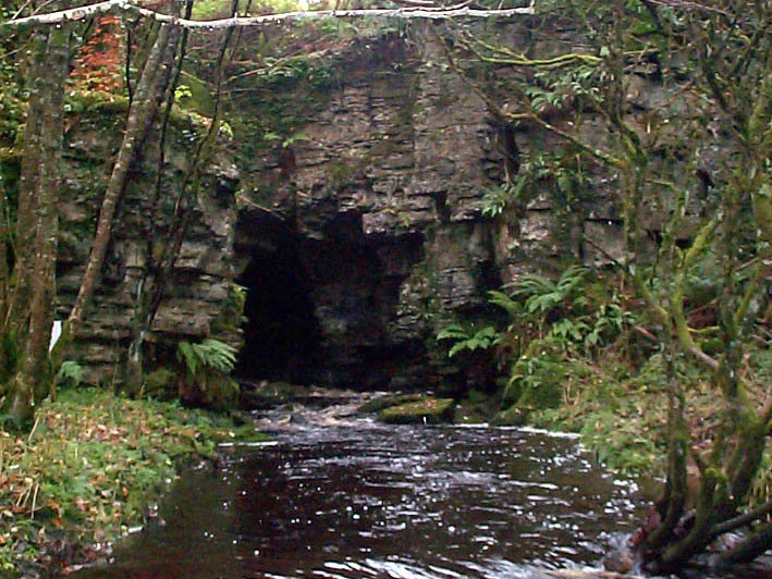

Boho Caves
In 1947, a parish priest named James McGirr was buried in soil that locals had been using as a folk cure for generations. They believed the earth at Boho had healing powers. They were not entirely wrong. Some seventy years later, a scientist named Gerry Quinn would scoop up a sample of that same soil and discover, hiding in it, a strain of Streptomyces bacteria capable of stopping MRSA. The Boho Caves themselves had been carving their way through Carboniferous limestone for 325 million years before anyone thought to look there for medicine, but the ground above them seems to know something we are only beginning to understand.
Stones from a Tropical Sea
The rock that the Boho Caves snake through formed when Ireland sat near the equator. During the Asbian substage of the Carboniferous period, around 325 million years ago, a warm shallow sea deposited the calcium carbonate that became the Dartry Limestone Formation. Above it lies the Meenymore Formation and Glenade Sandstone. Below run beds of cherty limestones and shales. The caves themselves wind only through the Dartry layer, dissolved out by acidic groundwater over hundreds of thousands of years. Inside, the passages show the textbook karst calling cards: stalactites hanging like stone icicles, stalagmites rising to meet them, rippled cave curtains, and sheets of flowstone where water has poured down walls for millennia.
The River That Vanishes
The water that flows through the Boho system rises in the Aghanaglack River, but the river does not always travel by the route you might expect. In dry weather, the streambed disappears entirely, the water sinking through invisible joints in the rock far upstream and reemerging far downstream past the ravine. In wet conditions, things get dramatic. The Main Sink swallows the river whole, occasionally overflowing into nearby field shakeholes when even the cave cannot keep up. In heavy floods, water bursts out of the Quarry entrance like a fire hydrant. The Upper and Lower Ravine Caves discharge their share through bedding planes at the northern end. The system breathes with the rain, sometimes calm, sometimes a roaring underground river.
Two Centuries of Visitors
People have known about these caves for hundreds of years. They appear on the six-inch Ordnance Survey maps of Ireland made between 1829 and 1841, and by 1870 the guidebook writer William Wakeman noted that tourists routinely arranged guided tours with local residents. In 1895, Édouard-Alfred Martel arrived. Martel was the father of French speleology, a methodical cave explorer who carried instruments and notebooks where others carried only candles. He came to Boho with the Irish naturalist Lyster Jameson, though scholars still argue over whether Martel actually descended into Boho Cave or only into nearby Pollnagollum Coolarkan. Jameson certainly went in both. He was after the cave fauna, and he found enough to write papers about it. The Yorkshire Ramblers followed in 1907, but the serious mapping had to wait until Dublin cavers attempted a survey in the 1960s, with the Reyfad Group completing a fuller picture in the 1980s.
The Bats of the Upper Ravine
Around fifty Daubenton's bats roost in the Upper Ravine Cave, a population that has been recognized as biologically significant since at least the late nineteenth century, when bats were observed here in July 1895. Daubenton's bats, also called water bats, are small brown mammals that skim insects from the surface of streams and ponds. They favor caves with steady draughts because the airflow brings them other small organisms called trogloxenes, creatures that visit caves without truly living in them. The bats need this. The Boho population thrives because the cave's airflow keeps the food supply moving. The system has been designated an Area of Special Scientific Interest, number 144, and the bats are why.
The Antibiotic in the Ground
The soil above the Boho Caves is alkaline and slightly radioactive, the kind of chemistry that produces unusual microbial life. In 2018, Professor Paul Dyson and his colleagues isolated a previously unknown strain of Streptomyces bacteria from a sample of that soil, naming it Streptomyces myrophorea, isolate McG1. The strain came from soil locals had used as a folk cure dating back to the Reverend James McGirr, who served as parish priest of Boho in 1803. When McGirr died, parishioners reportedly used soil from his gravesite as a remedy for ailments ranging from toothaches to infections. Laboratory testing showed the bacterium inhibits the growth of multi-drug resistant pathogens, including carbapenem-resistant Acinetobacter baumannii, vancomycin-resistant Enterococcus faecium, and methicillin-resistant Staphylococcus aureus. The list reads like a who's who of the antibiotic resistance crisis. Whether the discovery leads to new drugs is still uncertain. Whether it vindicates centuries of folk knowledge is harder to argue with.
Walking In
The sixth longest cave system in Northern Ireland sits beneath the northern slopes of Belmore Mountain, near the small village of Boho. The Boho Caves include the main passage, the smaller Waterfall Cave, and the Upper and Lower Ravine Caves, all interconnected by the same underground water system. Boho is the only example of a joint-controlled maze cave in Northern Ireland, which means its passages follow the geometric pattern of cracks in the bedrock rather than a single dominant stream channel. Access today is restricted out of concern for the bats, the cave formations, and the fragile microbial community in the soil above. But the system is there, beneath the green hills, working as it has worked for 325 million years.
From the Air
Located at 54.35 degrees north, 7.80 degrees west, on the northern slopes of Belmore Mountain in southwest County Fermanagh, Northern Ireland. Recommended viewing altitude 2,500 to 4,000 feet above terrain. Belmore Mountain (398 metres) is the most prominent visual landmark; the caves lie under the limestone uplands on its northern flank. The village of Boho is barely visible from the air, but the limestone scarps and small pastures with dry stone walls characterize the surface terrain. Nearest airports: St Angelo (EGAB) immediately to the east, Donegal (EIDL) to the northwest, Belfast International (EGAA) to the east. Atlantic weather brings frequent low cloud and rain.
Nearby Stories
- Ulster Canal 1.3 km away
- Cliffoney 3.5 km away
- County Leitrim 6.4 km away
- Ballymote 7.7 km away
- Gortin 11 km away
- Fintona 11 km away
- Glencolmcille 19 km away
- Castlederg 21 km away