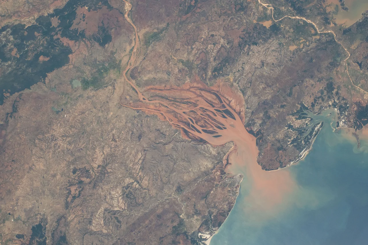

Bombetoka Bay
Astronauts have a name for the sight: Madagascar appears to be bleeding into the ocean. From the International Space Station, the northwest coast shows a startling wound of rust and crimson, where a river the color of dried blood fans out through a labyrinth of green islands into the blue Mozambique Channel. This is Bombetoka Bay, the estuary of the Betsiboka River - one of Madagascar's great rivers, a 525-kilometer waterway that gathers the red earth of the island's highlands and carries it to the sea. The color is not pollution in the ordinary sense. It is the island itself, dissolving and washing away, painted across the water in tones so vivid they are unmistakable from space.
The Color of a Wound
Madagascar's soils are lateritic - tropical weathering has leached away most of their nutrients over the ages, leaving behind iron compounds that stain the earth a deep rust red. When rain strips that soil from the land and the rivers carry it seaward, the water itself turns the color of blood. The Betsiboka begins far inland, in the central highlands north of the capital Antananarivo, and gathers the runoff of a basin spanning tens of thousands of square kilometers before reaching this bay. By the time it arrives, it is among the most sediment-laden rivers on the planet. The redder it runs, the more of Madagascar is being lost upstream - a slow hemorrhage of the very ground the island stands on, made visible in a single dramatic stain spreading across the estuary.
A Century of Erosion
The bleeding has worsened within living memory, and human hands are the cause. Since the 1950s, vast tracts of Madagascar's forests have been cleared for farming and fuel - by some estimates, roughly two-fifths of the island's tree cover gone. Forests once held the soil in place with their roots; stripped bare, the highlands began to wash away with every rainy season. Studies tracking the bay over recent decades record a dramatic surge in the sediment pouring into it. New islands and sandbars rise where the river drops its load, reshaping the estuary year by year. What looks from orbit like a timeless natural wonder is in fact a landscape transforming with alarming speed.
The Forest That Holds the Line
Threaded through all that sediment is one of Madagascar's great survivors: its mangroves. Bombetoka Bay shelters some of the island's largest remaining mangrove forests, their tangled roots gripping the shifting mud and trapping river sediment that would otherwise smother the coral reefs offshore. The reefs return the favor, breaking the surf that would tear at the mangroves. Within this shifting maze live dense communities of mollusks and crustaceans, sea turtles, and seabirds - and dugongs, the gentle marine grazers that have nearly vanished from Madagascar's waters but still browse the shallows here, in one of their last refuges along the coast.
A Working Estuary
For all its wildness, the bay is also a place where people make their living. Mahajanga, one of Madagascar's largest ports, sits at the estuary's mouth, and the surrounding lands hum with rice paddies, shrimp ponds, and coffee plantations climbing the hills. The bay's name lives in the city itself - Mahajanga was long known by its French name, Majunga, a trading port that for centuries linked Madagascar to the wider Indian Ocean world. But the same flood of sediment that builds the islands also fills the channels, and the changes of recent decades have cut hard against the people here - silting the harbor, fouling the fisheries, and complicating the shipping lanes that the port depends on. The blood-red water that astronauts admire from orbit is, for the families who live beside it, a daily reckoning with a landscape washing out from under them.
From the Air
Bombetoka Bay opens onto the Mozambique Channel on Madagascar's northwest coast, centered near 15.82°S, 46.27°E, just south of the port city of Mahajanga. It is one of the most visually arresting features in the region from altitude: a sprawling estuary where the rust-red, sediment-laden Betsiboka River braids through a maze of green mangrove islands and pale sandbars before reaching the blue sea - a vivid red-green-blue mosaic that has been photographed repeatedly from the International Space Station. The nearest airport is Amborovy / Philibert Tsiranana Airport at Mahajanga (ICAO: FMNM), only about 20 km north of the bay, giving excellent views on approach. Best seen in or just after Madagascar's wet season (November-April), when river flow and the red sediment plume are at their most intense.
Nearby Stories
- Ankarafantsika National Park 27 km away
- Baie de Baly National Park 52 km away
- Anjajavy Forest: Where Stone Forests Meet Living Ones 70 km away
- Lake Alaotra 270 km away
- Sunny South (clipper) 275 km away
- Mayotte Marine Natural Park 301 km away
- Zahamena National Park 325 km away
- Mayotte 327 km away