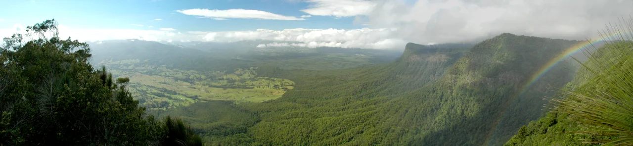

Border Ranges National Park
Stand at the edge of the Pinnacle and the ground simply falls away - a kilometre of air between your boots and the floor of the Tweed Valley below, with Wollumbin rising across the gulf like the core of the world laid bare. That is exactly what it is. The Border Ranges National Park rides the high rim of one of the largest erosion calderas on Earth, the ruins of a colossal volcano that erupted twenty-odd million years ago. Up here, on the escarpment, survives a rainforest so old it remembers the supercontinent of Gondwana - a green, dripping, primeval world that Australia has carried almost unchanged across deep time.
Rim of a Ruined Volcano
Everything about this landscape was shaped by a single ancient catastrophe and the long aftermath of erosion. The Tweed shield volcano, centred on what is now Wollumbin/Mount Warning, once dominated the region. Over roughly twenty-three million years, weather and rivers stripped it down, carving out the vast Tweed Valley caldera that opens to the sea - a basin some forty kilometres across, the largest erosion caldera in the Southern Hemisphere and one of the biggest on the planet. The Border Ranges, including the McPherson and Tweed Ranges and the Lamington and Levers Plateaus, are the eroded edges of that volcanic dome. Scattered through the park stand volcanic plugs, the hardened throats of old vents left behind as everything softer washed away.
A Forest Out of Gondwana
The park's rainforests are part of the Gondwana Rainforests of Australia World Heritage Area, and the phrase is not hyperbole. These are living descendants of the forests that covered the ancient southern supercontinent, and they shelter an astonishing concentration of life. Along Brindle Creek, subtropical rainforest flora is preserved in deep, fern-choked green. The park holds one of the most diverse ranges of spider species of any montane rainforest in Australia. In the lower eucalypt forests live eastern grey kangaroos, red-necked wallabies and koalas; pademelons and the secretive potoroo move through the undergrowth. And somewhere in the canopy sings the rare Albert's lyrebird - a shy, brilliant mimic found almost nowhere else on Earth, and one of the great prizes for anyone who listens patiently here.
The Tweed Range Scenic Drive
The way to see the park is the Tweed Range Scenic Drive, a roughly sixty-four-kilometre gravel touring route - part of the wider Rainforest Way - that loops through the high country from Lillian Rock, between Uki and Kyogle, around to Wiangaree north of Kyogle. It is a road to take slowly and only in dry weather, winding through mountain rainforest with the valley falling away at every bend. Lookouts punctuate the drive: Blackbutts, with its sweep toward Wollumbin and across the Tweed Valley, and the short walk out to the Pinnacle, which delivers the park's signature view straight down the crater escarpment. Modest camp grounds and picnic areas sit tucked into the forest along the route - the kind of places where you wake to birdsong and mist.
Watching the Caldera Wake
The finest hour in the Border Ranges is sunrise. From the Pinnacle lookout, the first light catches the crater escarpment, Wollumbin, and the distant coast all at once, and the enormity of the place finally makes sense - the rim you are standing on, the valley a kilometre below, the lone peak that is all that remains of the volcano's heart. It is a quiet, vast, slightly humbling thing to witness. Added to the Australian National Heritage List in 2007 and protected since 1979, this park asks little of its visitors beyond patience and an early alarm. Come for the view; stay for the forest that has been growing here, undisturbed, since long before there was anyone to admire it.
From the Air
Border Ranges National Park spreads across roughly 28.36°S, 152.99°E in far northern New South Wales, with a small portion crossing into South East Queensland, about 150 km south of Brisbane. The park rides the western and northern rim of the Tweed/Mount Warning caldera; from the air the great horseshoe of the eroded crater is unmistakable, with the sharp plug of Wollumbin/Mount Warning rising near its centre to the east. The escarpment drops steeply to the Tweed Valley some 1,000 m below the Pinnacle lookout. The 64 km Tweed Range Scenic Drive traces the high country between Lillian Rock and Wiangaree. Nearest airports are Lismore Regional (YLIS) about 40 km to the south-east and Ballina Byron Gateway (YBNA) on the coast; Gold Coast (YBCG) lies to the north-east. Cloud and rain build readily over the ranges - clear, calm mornings offer the best views across the caldera.
Nearby Stories
- Cape Byron Marine Park 5.5 km away
- Spicers Gap Road 17 km away
- The Channon 18 km away
- Glow-Worm Caves Tamborine Mountain 23 km away
- Cape Byron 27 km away
- Allan Cunningham Monument 42 km away
- Bald Rock National Park 56 km away
- HMS Porpoise (1799) 682 km away