.jpg)
Cache Creek Wilderness
The soil here is poisonous, and that is precisely the point. Cache Creek Wilderness sits on a bed of serpentine rock -- greenish stone forged from peridotite deep in Earth's subduction zones, then thrust to the surface carrying a cocktail of asbestos, mercury, copper, and magnesium that kills most plants on contact. Most, but not all. Over millennia, a specialized flora evolved to thrive in what would be lethal ground for ordinary species, and approximately twenty percent of California's rare and endemic plants grow exclusively in soils like these. What looks from the air like rough, half-barren hill country is in fact one of the state's most botanically significant landscapes.
Poison as Cradle
Serpentine rock tells a story that begins at the boundary between tectonic plates. Peridotite, a dense mantle rock, gets dragged into subduction zones where intense heat and pressure transform it into serpentinite. Because it is less dense than the surrounding rock, it rises back toward the surface, carrying its toxic mineral load with it. The resulting soils are inhospitable to most vegetation -- high in heavy metals, low in essential nutrients like calcium. But evolution is resourceful. Leather oak, a gnarled variety of Quercus durata, grows almost nowhere else. Hall's harmonia, an aromatic annual wildflower, and the adobe lily are both listed as category 1B by the California Native Plant Society, meaning they meet every criterion of the state's Endangered Species Act. These are plants that did not merely adapt to serpentine soil -- they became dependent on it, outcompeting ordinary species precisely because ordinary species cannot survive here.
Elk, Eagles, and Eleven Thousand Years
The 27,245-acre wilderness area, managed by the Bureau of Land Management, shelters California's second-largest herd of tule elk -- a subspecies that once roamed the Central Valley in the hundreds of thousands before European settlement reduced them to a single breeding pair in the 1870s. Their recovery is one of California's quieter conservation triumphs, and the Cache Creek herd grazes the open meadows and steep, rounded hills as though the intervening century of near-extinction never happened. Bald eagles maintain a year-round presence here, nesting in the riparian corridor along the creek. And beneath the chaparral and manzanita, archaeologists have documented the remains of a large Hill Patwin village occupied around eleven thousand years ago -- evidence that humans recognized the value of this landscape long before Congress got around to protecting it in 2006.
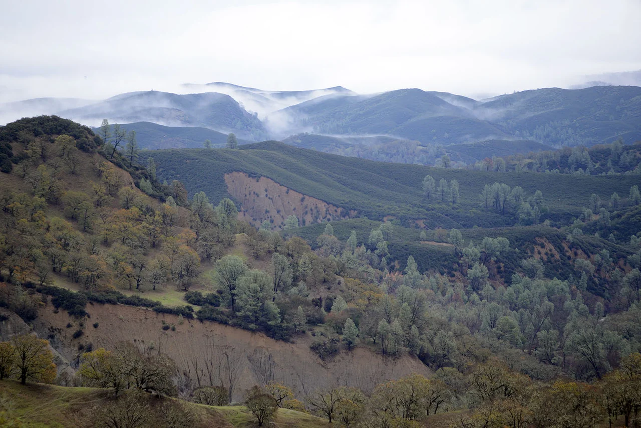
Where the Creek Runs Wild
Cache Creek itself is the spine of this wilderness. A tributary of the Sacramento River in wet years, it flows east from Clear Lake through more than thirty miles of canyon designated as a California Wild and Scenic River. Along its banks, willows and alders form a green corridor through otherwise dry, chaparral-covered terrain. The creek is one of two tributaries -- Putah Creek being the other -- that represent the most southerly significant east-flowing drainages from the Coast Ranges into the Sacramento River basin. That hydrological distinction matters because it makes Cache Creek an important corridor for riparian and fish habitat in a region where such corridors are increasingly rare. The highest point in the wilderness, a summit called Brushy Sky High, reaches 3,176 feet and offers views across a topography of steep hills, open meadows, cliffs, and stream canyons that stretch to the horizon in every direction.
Monument Country
The wilderness area was carved out of the larger Cache Creek Natural Area -- more than 70,000 acres of public land -- when Congress passed the Northern California Coastal Wild Heritage Wilderness Act in 2006. Nine years later, in July 2015, the story expanded further when Cache Creek became part of the Berryessa Snow Mountain National Monument, a sweeping designation that linked scattered public lands across the inner Coast Ranges into a single protected corridor stretching from the snow line to the valley floor. The monument recognized what the serpentine soils had been demonstrating for millennia: that this landscape's value lies not in what it can produce for human use but in what it produces on its own. The manzanita, the gray pine, the toyon with its red winter berries, the deerbrush and scrub oak clinging to the canyon walls -- all of it persisting on ground that by most measures should not support life at all.
From the Air
Located at 38.92N, 122.51W in Lake County, California, roughly 10 nm southeast of Clear Lake. The wilderness occupies rugged terrain in the inner Coast Ranges with a highest point at Brushy Sky High (3,176 ft). Best viewed from 4,000-6,000 feet AGL where the serpentine outcrops and sparse vegetation contrast with surrounding oak woodlands. Cache Creek itself is visible as a winding riparian corridor cutting through otherwise dry, brown-green hills. Nearest airports: Lampson Field (1O2) in Lakeport, approximately 20 nm northwest. Part of Berryessa Snow Mountain National Monument.
Nearby Stories
- The People of the Roundhouse 5.2 km away
- Where Three Hundred Thousand Wings Descend 6 km away
- Robert Louis Stevenson State Park 7.5 km away
- Austin Creek State Recreation Area 12 km away
- From Radio Towers to Tribal College: D-Q University 15 km away
- The Valley That Drowned 15 km away
- Berryessa Snow Mountain National Monument 21 km away
- The Day Two Nuclear Bombs Fell on Yuba City 22 km away