
Caerleon Roman Fortress and Baths
When Gerald of Wales rode through Caerleon in 1188, recruiting men for the Third Crusade, the ruins were so vast he wrote them down. He saw immense palaces, a tower of prodigious size, hot baths, the relics of temples and theatres - all inside walls that still stood high. Underground passages ran beneath the streets. Heating stoves built into the walls transmitted hot air through narrow clay tubes. "Caer-leon," he wrote, "means the city of legions, for there the Roman legions, sent into this island, were accustomed to winter." Much of what he described would be demolished or buried in the centuries that followed. The vast stone bathhouse was destroyed in the 13th century, probably for its building materials. But Caerleon refused to disappear. Today it remains one of only three permanent legionary fortresses from Roman Britain - and the one where most has survived.
Isca Augusta, AD 75
Rome reached the south-east coast of Britain in AD 43. Thirty-two years later, with the Silures of South Wales finally subdued, the Second Augustan Legion built a permanent fortress on the west bank of the River Usk where it met the Severn Estuary. They called it Isca Augusta - Isca from the river name, Augusta from their own honorific. The site was strategic: navigable river giving access to the sea, defensible ground, control of the routes into the Welsh hills. Caerleon was one of only three such permanent legionary fortresses in Roman Britain. The others were Eboracum (York) and Deva Victrix (Chester). What sets Caerleon apart from those two is what happened afterwards. York and Chester became major medieval cities, building over and through their Roman layers. Caerleon shrank back to a Welsh village. The Roman footprint was preserved, in geographic accident, by being left mostly alone.
The Bath House and the Soldiers Who Used It
The fortress bath house was probably the only stone building in the original AD 75 fortress, which was otherwise constructed of timber. It was the principal baths for the legion - thousands of men, day after day, working through a sequence of cold, warm, and hot rooms. Excavated between 1977 and 1981 by J. David Zienkiewicz, the baths have been preserved in situ and opened to the public in 1980 under the care of Cadw, the Welsh historic environment service. Today you walk on a covered walkway over the actual flagstones. There was a frigidarium for the cold plunge, a tepidarium for the warm transition, and a caldarium for the steam. An open-air swimming pool ran alongside. Projected imagery now plays scenes of Roman bathers across the walls, so that the empty cisterns and channels are inhabited again by the people who actually used them. Over 40,000 people visited the baths in 2012 alone.
The Amphitheatre and the Round Table
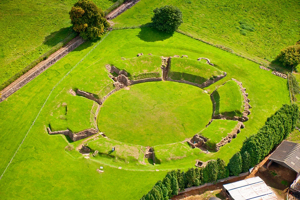
Just outside the fortress wall sits the most complete excavated Roman amphitheatre in Britain. It held perhaps 6,000 spectators - roughly one for each soldier of the Second Augustan Legion - and would have been used for military training and ceremonies as well as gladiatorial contests. When Geoffrey of Monmouth wrote his Historia Regum Britanniae around 1136, he made Caerleon the capital of King Arthur and set Arthur's coronation feast there. The huge oval of the amphitheatre got pulled into the legend, often cited as a possible origin of the Round Table. Whatever Arthurian truth lies under the Welsh mythology, the amphitheatre is real and you can walk down into its entrance tunnels still. Within a short walk are the fortress walls, the bath house, and the only Roman legionary barracks visible anywhere in Europe - the foundations at Prysg Field, excavated by V. E. Nash-Williams in 1927-29 and laid out as public parkland.
Antiquarians and the First Welsh Museum
The modern story of Caerleon's archaeology begins in October 1847, when local antiquarians founded the Caerleon Antiquarian Association with twin aims: to dig, and to build a museum. The first secretary, John Edward Lee, had already started excavating an extramural bath house alongside the medieval castle motte. Finds accumulated faster than anyone could properly catalogue them. An early plan was to lease an old market building owned by Sir Digby Mackworth - the first chairman - which incorporated four Roman pillars. When that building proved impractical, it was demolished and the pillars re-used in a new museum building on a new site. The museum opened in summer 1850 to display recent finds along with items donated by Caerleon residents who had been picking pieces of Rome out of their gardens for generations. It became the National Roman Legion Museum, still open today, still telling the story it was founded to tell.
What 21st-Century Geophysics Found
From 2007 to 2010, Andrew Gardner of University College London and Peter Guest of Cardiff University excavated Priory Field in the south-west corner of the fortress. They uncovered a large square building that collapsed or was demolished around AD 350 - and dug out thousands of finds, including entire sets of Roman armour. An inscription named its builder: Flavius Rufus, who had risen to be Primus Pilus, the senior centurion of the Second Augustan Legion. Possibly a first-generation Roman citizen, climbing the ladder one promotion at a time. In 2011 Guest led a follow-up between the amphitheatre and the river, where geophysical survey had revealed massive structures south of the fortress. Test trenches confirmed three vast public buildings around courtyards, one of them 150 by 120 metres - with a central courtyard larger than the amphitheatre - and a Roman port on the Usk, only the second one ever found in Britain. The other was London. By the end of the 2nd century the southern canabae had been abandoned. By the 4th century the fortress itself was probably reduced. By around 650 AD, cottages had grown over the ruins. The Romans had been gone for two centuries, but Caerleon never quite was.
From the Air
Caerleon Roman Fortress and Baths sit at 51.61005°N, 2.95529°W on the west bank of the River Usk, about 5 miles north-east of Newport city centre. From cruising altitude in clear weather, the distinctive oval of the Roman amphitheatre is identifiable on the southern edge of the village, with the fortress footprint outlined in modern street patterns. Nearest airport is Cardiff (EGFF), 15 miles west; Bristol (EGGD) is across the Severn Estuary 25 miles east. The River Usk loops past the site to the south. Best viewed at lower altitudes where the amphitheatre, the bath house, the barracks at Prysg Field, and the line of the fortress walls can all be picked out. Often combined with a visit to Caerleon village itself, which sits inside the former fortress.
Nearby Stories
- Coal tips in Wales 2.3 km away
- Charfield Railway Disaster 5.9 km away
- Llanthony Priory 11 km away
- Llanthony Secunda Priory 14 km away
- Porlock 14 km away
- Cheddar Gorge 16 km away
- Longleat 21 km away
- Battle of Cadfan 33 km away