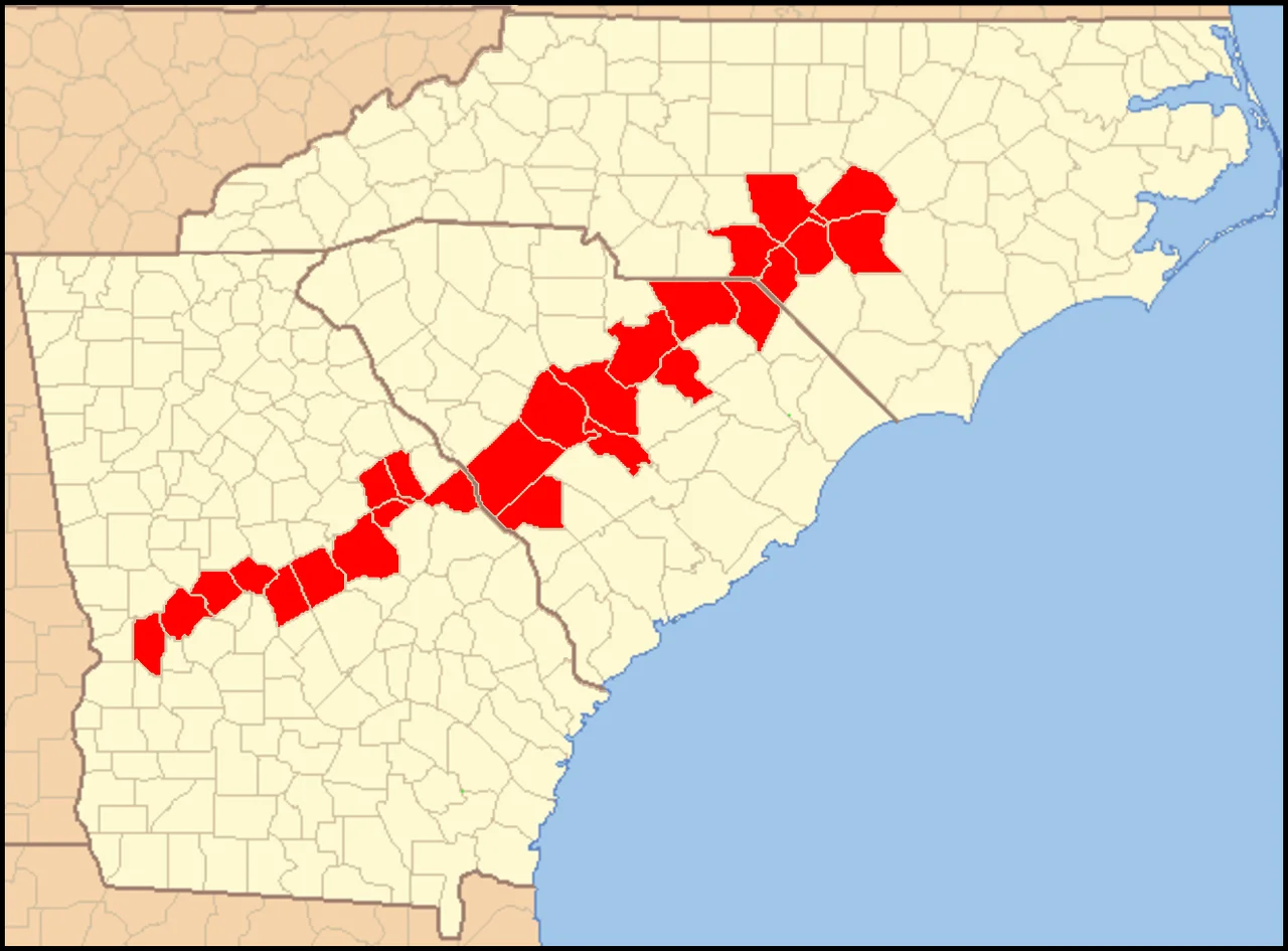

Carolina Sandhills
The sand is older than the last ice age and the dunes were made by wind. Between roughly 75,000 and 6,000 years ago, when North America's southeast was colder, drier, and sparsely vegetated, hard winds blew sand sheets and dunes out of Cretaceous river deposits and piled them along the inland edge of the Atlantic Coastal Plain. That belt is the Carolina Sandhills - 10 to 35 miles wide, threading from southern North Carolina across South Carolina into eastern Georgia. Geologists call the sand the Pinehurst Formation. Botanists call what grew on it the longleaf pine ecosystem. People called this land Carolina's Piney Woods. Today, only about one percent of the original longleaf forest remains.
Wind and Older Wind
The Pinehurst Formation is Quaternary - geologically yesterday by comparison with what sits underneath it. The sand was sourced from Cretaceous river deposits about 100 million years old, mapped in the Carolinas as the Middendorf Formation. When luminescence dating tells you when those sand grains last saw daylight, the answer keeps coming back to the last glacial period. Stronger winds, less plant cover, drier soils - the conditions that built dunes across the inland Plain. Sugarloaf Mountain in the Sand Hills State Forest of Chesterfield County, South Carolina, is a notable outcrop of those older Cretaceous strata standing up where the Quaternary sand has thinned. The soils that result are sandy almost beyond reason - Alpin and Candor series in USDA surveys, soils that drink rainwater straight down and hold almost nothing.
Longleaf and Fire
What grew on sand that thirsty was longleaf pine, Pinus palustris, locked in a partnership with a grass: wiregrass, Aristida stricta. Together they made one of North America's great ecosystems. At its peak the longleaf-wiregrass forest covered roughly 60 percent of the Atlantic and Gulf Coastal Plains - a fire-maintained savanna where lightning strikes started low-intensity ground fires every two to five years. The fires killed competing hardwoods, cleared brush from the forest floor, opened the longleaf cones, and let wiregrass produce seed. The longleaf evolved to survive what would kill almost any other tree. Today that ecosystem is a ghost. About one percent of the original longleaf forest remains. The rest was logged for timber, drained for farms, paved for cities, or invaded by faster-growing pines after fire was suppressed.
The Woodpecker and the Tree Frog
More than thirty plant and animal species native to the longleaf ecosystem are now threatened or endangered. The most famous is the red-cockaded woodpecker, Dryobates borealis, a small black-and-white bird that excavates nesting cavities only in living longleaf pines that are 80 to 120 years old. The bird needs forests old enough that almost none exist anymore. Wildlife biologists have spent decades drilling artificial cavities in surviving old longleafs to keep the woodpecker breeding. The other rare specialist is the Pine Barrens tree frog, Dryophytes andersonii, which lays its eggs in acidic shallow ponds and tolerates pH levels that would kill other amphibians. It lives in only three places in the world: the Carolina Sandhills, a sliver of southern Alabama and the Florida panhandle, and the New Jersey Pine Barrens. It is also the official state frog of North Carolina.
The Goobers and What Saves What's Left
The people who lived in the Piney Woods during the 1800s were called Goobers - the same name as the peanut, a word that came over from West Africa as nguba. The Sand Hills cottage architectural style, a stripped-down Greek Revival adapted to the sandy soils and pine forests of the region, developed during this period. The longleaf forest fed the Goobers' families, supplied the tar and turpentine and pitch industry that built much of the colonial American shipping fleet, and finally got logged out almost completely by the early twentieth century. The Carolina Sandhills National Wildlife Refuge - 45,000 acres in Chesterfield County, South Carolina, near McBee - is the largest preserved fragment. Smaller pieces survive at Weymouth Woods in Southern Pines and the Sandhills Gamelands. Prescribed burns now do what lightning used to do. Slowly, the longleaf is being replanted. Recovery, when it happens at all in ecosystems this scarred, is measured not in years but in centuries.
From the Air
The Carolina Sandhills region centers roughly at 35.17 degrees N, 79.44 degrees W in southern North Carolina, extending 10 to 35 miles wide from the Sandhills of central NC southwest across South Carolina into Georgia along the inland edge of the Atlantic Coastal Plain. Elevation 200-700 feet. The signature visual is the pine-savanna canopy of longleaf where it survives - much more open and grass-covered than the dense loblolly pine plantations that have replaced it elsewhere. Nearest airports: Moore County (KSOP) in Pinehurst; Fayetteville Regional (KFAY); Raleigh Executive Jetport (KTTA) at Sanford; Asheboro (KHBI). Recommended viewing altitude 3,000-5,000 feet AGL. The Sandhills are visible as a pale, sandy band where forest is broken; the surviving longleaf stands have a distinct sparse-canopy look compared to surrounding hardwood and pine plantation forest. Watch for prescribed burn smoke during late winter and early spring.
Nearby Stories
- Battle of Averasborough 7.5 km away
- Deep River Camelback Truss Bridge 7.7 km away
- North Carolina Aviation Museum 18 km away
- Red Springs, North Carolina 20 km away
- Yates Mill 24 km away
- Battle of Colson's Mill 27 km away
- Cheraw, South Carolina 33 km away
- Duplin County, North Carolina 75 km away