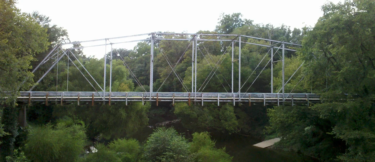

Deep River Camelback Truss Bridge
The bridge has lived twice. In 1901 it went up over the Cape Fear River at Lillington, one span of a longer crossing. When part of that bridge collapsed in December 1930, the rest was taken down to make room for a new structure. Two years later, in 1932, one of the salvaged spans was carried thirty miles northwest and reassembled over the Deep River between the hamlets of Gulf, in Chatham County, and Cumnock, in Lee County. It replaced a wooden covered bridge that had burned about 1929. Today it sits on stone and concrete piers in a quiet rural park, open only to pedestrians, while cars use the newer concrete bridge a hundred yards east.
The Shape Itself
A camelback truss is not a fashion statement. It is a Pratt truss with a top chord shaped into a low arch - five slopes instead of a flat run - that lets the bridge carry a heavier deck for less steel. Engineers built them between roughly 1880 and 1935, when American railroads and rural road agencies needed sturdy medium-span crossings on a budget. The math is honest: every diagonal works in tension under load, every vertical in compression, and the broken-line top chord lets the engineer concentrate steel where the moment is highest. The deck is a plank floor topped with a macadam road surface. Underneath, the metal looks like a child's drawing of a bridge until you start counting rivets.
Coal, Iron, Copper
The river the bridge crosses runs through what was once industrial country. Through much of the nineteenth century, this stretch of the Deep River was the site of coal pits, iron foundries, and copper mining operations - some of the few hard-rock workings in the Carolina Piedmont. Bridges have served this crossing since at least 1833. A nineteenth-century fieldstone pier still holds up the present bridge on the north end, probably the surviving pier of an earlier structure called Evans Bridge after Peter Evans, whose plantation Egypt lay on the south bank. The plantation name was a piece of Old South theatre. The work that built it was not.
One of Four
By 1979 the North Carolina Department of Transportation had identified thirty-five metal truss bridges - eight of them camelbacks - that deserved formal recognition as important examples of early-twentieth-century engineering. Truss Bridge No. 155, as the NCDOT calls it, is one of only four camelback trusses still standing anywhere in North Carolina. The new concrete crossing opened in 1992. Ownership of the old bridge passed to the Deep River Park Association, which preserves it in place as part of a Rails-to-Trails route along the river corridor. The deck is closed to vehicles. It is open to feet.
A Park, Not a Highway
Deep River Park surrounds the bridge with picnic tables, a boat ramp for kayaks and canoes, and the kind of quiet that southern Piedmont woodlands deliver when nobody is logging them. Geocachers come for the hidden caches near the abutments. Cyclists ride the Rails-Trails route through the woods. The mining ruins are mostly gone, swallowed by hardwood second growth, but the river itself still drops over old fall lines that once powered the foundries. The bridge stands across the water with the new bridge visible just downstream, an honest contrast: a hundred and twenty-five years of riveted steel versus a few decades of poured concrete, both still doing their job.
From the Air
The Deep River Camelback Truss Bridge sits at 35.570N, 79.241W on the Chatham-Lee county line in Deep River Park, accessed via Cumnock Road from US-421. Field elevation around 350 ft MSL. The river runs roughly southwest-to-northeast here, and the bridge is small enough that lower altitudes are needed - 1,500 to 2,500 ft AGL gives the best view of the truss profile against the water. Nearest airports: Siler City Municipal (KSCR) about 12 nm northwest, Raleigh Executive Jetport (KTTA) about 18 nm southeast, Greensboro-Piedmont Triad (KGSO) about 35 nm northwest, Raleigh-Durham (KRDU) about 35 nm east.
Nearby Stories
- Battle of Lindley's Mill 7.1 km away
- North Carolina Aviation Museum 10 km away
- Battle of Averasborough 10 km away
- Yates Mill 15 km away
- High Point, North Carolina 21 km away
- Purefoy-Dunn Plantation 22 km away
- Carolina Sandhills 23 km away
- Battle of Colson's Mill 32 km away