Carteret Islands
The highest point on the Carteret Islands is about a meter and a half above the sea. Stand anywhere on Han, the main island, and you are never more than a short walk from saltwater closing over the garden beds. The islanders call themselves the Tuluun, speak a language related to the Halia of nearby Buka, and have lived on this horseshoe of sand and coral for generations - long enough that their grandmothers' grandmothers would have heard the same surf, watched the same palms bend in the same winds. Now the wind and the sea are bringing something else. The taro gardens are going brackish. The well water tastes of the ocean. The shoreline where children used to play is underwater at high tide. Ursula Rakova, who has spent years leading her community's slow, painful search for new land, tells interviewers that she wants the world to know one thing first: the Tuluun are not victims. They are survivors.
A Horseshoe in the Pacific
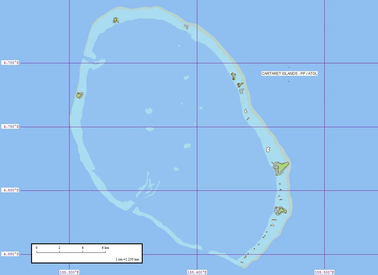
The Carteret atoll lies 86 kilometers northeast of Bougainville, a scatter of islets - Han, Jangain, Yesila, Yolasa, and Piul - arranged in a horseshoe about 30 kilometers long. The total land area is roughly 0.6 square kilometers, smaller than many university campuses, and the highest point is 1.5 meters above sea level. The main settlement is at Weteili on Han. The reef sits near the edge of the Ontong Java Plateau, one of the largest volcanic features on Earth, though what you see on the surface is only coconut palms leaning over white sand and a lagoon the color of glass. British navigator Philip Carteret sighted the atoll in his sloop on 24 June 1767 and lent it the name that stuck in European charts. The people who already lived there had other names for home.
The People Who Call Themselves Tuluun
Oral tradition says the islands were first settled by Polynesians, likely related to the people of Takuu and Nukumanu, who lived here until the early 18th century when the Halia of Hanahan Bay arrived from Buka in a flotilla of canoes. What followed was a conquest, remembered differently by both sides: the Halia tradition frames it as retaliation for an earlier massacre, while the Mortlock Islanders remember a surprise attack on their relatives. Out of that violent meeting came the community that lives on the atoll today - Halia-speaking, matrilineal, organized around two groups called Nakaripa and Naboen, with chiefs who arrange cross-moiety marriages because legitimate authority requires the consent of the opposite side. The Tuluun have lived here, fishing the lagoon, tending taro and coconut, for centuries. European contact came in earnest around 1880 with the copra trade. The population has swung between growth and hardship ever since.
When the Sea Stopped Staying Put
Climate change did not arrive at the Carterets as a single event. It came as a series of small, cumulative losses that could, at first, be attributed to a bad season or a strong storm. Gardens that had grown swamp taro for generations began to die at the roots from salt. The freshwater lens beneath the islands - that thin lens of rainwater that floats on denser saltwater and makes island life possible - started to go brackish. Storm surges came in harder and more often, washing away kitchens, eating at the seawall the community built, taking trees that had held the sand together. Coconut palms that lose their grip in a storm rarely grow back. The island has a way of un-making itself when the conditions that made it are withdrawn. District manager Paul Tobasi and many others have documented the accelerating shift. In 2005, news reports announced the islands would be uninhabitable by 2015 - a projection that proved incorrect, but the underlying trajectory remains.
The Hardest Decision
In November 2003, the Papua New Guinea government authorized a full evacuation, ten families at a time. Funding lagged. Plans stalled. In October 2007, the government committed two million kina (about US$736,000) through an organization called Tulele Peisa, based in Buka and led by Ursula Rakova. Five Tuluun men moved to Bougainville in early 2009 and began building houses and planting crops so their families could follow. The plan called for 1,700 more people over five years. Reality moved slower. By 2021, ten families had relocated to Tinputz on Bougainville. In 2017, the Finnish Embassy in Canberra, involved in aid work on the atoll, reported that despite relocation, there were more people than ever living there, the population roughly doubled. Leaving is harder than any spreadsheet captures. The documentary Sun Come Up, nominated for an Academy Award in 2011, follows a group of young Tuluun as they travel to Bougainville to ask for land - carrying shells as currency, wary of weapons and alcohol they have never known, worrying, even as they succeed, that once they live in Tinputz they will become Tinputz people, and what was Tuluun will live only in memory.
A Message in a Rising Tide
Ursula Rakova puts it plainly in interviews: if her community does not move, they will be washed away, and the rest of the world will eventually have to ask whether enough was done. The Carteret Islanders did not produce the emissions that are taking their islands. They are carrying the cost anyway, along with the small Pacific nations and low-lying communities that will follow them. The Tuluun are frequently called the world's first climate change refugees, though they prefer the word survivors. Either way, they are showing the rest of us something it is easier not to see: what it looks like when a culture has to choose between land and future, and what is left when those two things can no longer be the same place.
From the Air
Located at 4.76 degrees S, 155.39 degrees E, 86 km northeast of Bougainville Island in the Autonomous Region of Bougainville, Papua New Guinea. From altitude, the atoll appears as a faint horseshoe of white islets around a pale blue lagoon, sitting on the edge of the vast Ontong Java Plateau. Best viewed at 4,000 to 6,000 feet; the islets are only 1.5 meters above sea level and easy to miss against the open Pacific. Nearest airport is Buka Airport (AYBK) on Buka Island, about 90 km to the southwest. Tropical convective weather dominates; visibility is best in the early morning before afternoon cumulus builds.
Nearby Stories
- Buka Island 18 km away
- Kilu Cave 56 km away
- Battle of the Green Islands 58 km away
- Battle of Porton Plantation 70 km away
- Takuu Atoll 139 km away
- Japanese Seaplane Carrier Nisshin 172 km away
- Duke of York Islands 310 km away
- Shumshu 6152 km away