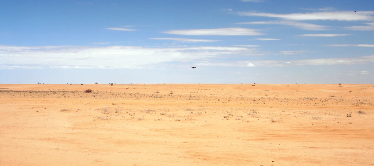

Chalbi Desert
Ten thousand years ago, you could have drowned here. The Chalbi was a lake then, a shallow inland sea east of Lake Turkana, fed by rains that no longer fall. The water retreated over millennia and left behind its ghost: a crust of dried mud and salt stretching to the horizon, so flat and so bright that on a hot afternoon the ground dissolves into mirage and the sky pools where water used to be. The Gabbra people, who herd camels across this country, named it with brutal economy. In their language, Chalbi means "bare, salty area." It is one of the smaller deserts of Africa and one of the least forgiving, a place defined less by sand than by the absence the lake left when it died.
The Lake That Left
The Chalbi runs about 110 kilometres long and 10 to 20 kilometres wide, wedged between the green slopes of Mount Marsabit and the jade waters of Lake Turkana. Its floor is the bed of that ancient lake, a shallow body of water that existed roughly 10,000 to 11,000 years ago when the African climate was wetter. What remains is a mosaic of cracked lakebed, rocky pavement, and old lava flows, the volcanic hills offering the only relief in an otherwise level expanse. The ground itself tells the story of evaporation: layered mud and salt, baked iron-hard under the sun. The salt here is real enough that pastoralists scrape it from the pans and carry it home as a natural lick for their animals, harvesting the mineral residue of a lake that vanished before the pyramids were built.
Rain in a Rain Shadow
Chalbi is a rain-shadow desert, kept dry by the mountains that wring the moisture from passing weather. But when rain does come, it arrives as violence. Heavy downpours sheet off the hardened surface, unable to soak in, and pool in the desert's low depressions. In years of exceptional rainfall a temporary lake reappears, a brief resurrection that can linger for several months before the sun reclaims it. The transformation is total. The same crust that splits and sticks underfoot turns to a soft, treacherous mud, swallowing tires and hooves alike. Sandstorms are a regular feature, walls of grit that roll across the flats and erase the horizon. To cross the Chalbi is to gamble on which desert you will meet: the cracked white pan, the flooded mirror, or the blinding storm.
Life at the Margins
Nothing about the Chalbi suggests abundance, yet life clings to its edges. Oryx pick across the flats, their pale coats matched to the glare. Reticulated giraffe, Grevy's zebra, and the Somali ostrich move through the surrounding grasslands, and even African elephants pass through this hard country. The animals follow the same logic the Gabbra do: they go where the water is. At the desert's margins, springs surface and grasses grow, small green islands in the salt. The oasis at Kalacha is the most celebrated, a stand of doum palms fed by a spring where Gabbra herders bring their camels by the hundreds to drink. Settlements like Maikona, Kalacha, and North Horr ring the desert, trading centres that exist because somewhere nearby, water finds its way to the surface.
The Gabbra and the Long Walk
The Chalbi belongs, in every sense that matters, to the Gabbra. They are camel pastoralists, a people who have made a life in one of the driest inhabited corners of Kenya by reading the land the way others read a map. Their herds of camels, goats, and cattle convert thornscrub and salt-flecked grass into milk and meat. Their routes between water points are knowledge passed down rather than written, a living atlas of where the springs run and when the rains might come. For decades the wider county of Marsabit was treated as Kenya's forgotten edge, marginal and remote. In recent years the Chalbi has begun to draw travelers chasing its stark beauty, but for the Gabbra it was never empty or strange. It is simply home, and the long walk across it is just the shape of an ordinary day.
From the Air
The Chalbi Desert lies around 3.03°N, 37.35°E in Marsabit County, northern Kenya, between Mount Marsabit to the southeast and Lake Turkana to the west. The nearest airfield is Marsabit Airport (ICAO HKMB / IATA RBT), about 4,390 ft elevation, with charter strips including Segel toward the desert itself; Loyangalani Airport sits to the west near Lake Turkana. From altitude the desert is unmistakable: a brilliant white-to-tan salt plain set against the darker volcanic terrain and the green dome of Mount Marsabit, with the blue of Lake Turkana on the western edge. Watch for blowing dust and sandstorms that sharply cut visibility; clearest air comes in the dry months.
Nearby Stories
- Marsabit 53 km away
- Nataruk 87 km away
- Central Island 98 km away
- Suguta Valley 118 km away
- Koobi Fora 155 km away
- Kanapoi 162 km away
- Gedeo Cultural Landscape 212 km away
- Wagalla Massacre 262 km away