The Ciliwung: A River That Built and Broke a Capital
Its name may come from a temperamental king. In Sundanese, "ci" simply means river, but "liwung" - the whirlpool, the distressed, the twisting one - might trace back to Prabu Haliwungan, a ruler of the Pajajaran kingdom whose volatile moods became legend. Whether or not the etymology holds, it fits. The Ciliwung is a river of moods: serene in its volcanic headwaters above Bogor, muscular as it cuts through alluvial fans and ancient lava deposits, and increasingly desperate as it enters Jakarta, where four million people press against its banks and its floods reshape neighborhoods year after year.
From Volcano to Sea
The Ciliwung begins at Mandalawangi in the Bogor Regency, high on slopes that reach 3,002 meters where active volcanoes - Mount Salak, Mount Kendeng, Mount Halimun - feed its tributaries. The river's 476-square-kilometer catchment drains through terrain that changes character dramatically over its 119-kilometer course. In the uppermost 17 kilometers, the slope is steep at 0.08 - a mountain stream tumbling over tuffaceous breccia and old lahar deposits. The middle reach flattens to 0.01 across 25 kilometers of Quaternary alluvial fans and volcanic rock. Then comes the downstream stretch: 55 kilometers at a near-flat slope of 0.0018, where the river spreads across alluvial and beach ridge deposits on its way to Jakarta Bay. Mean annual rainfall reaches 3,125 millimeters. Mean discharge at the Ratujaya observation station is 16 cubic meters per second. Those numbers sound modest until the monsoon arrives and the Ciliwung remembers its name.
Kingdoms on the Current
People have lived along the upper Ciliwung since at least the 4th century. The kingdom of Tarumanegara, founded near present-day Bogor with King Purnawarman at its head, left inscriptions at Ciaruteun that survive to this day. A thousand years later, the Hindu kingdom of Sunda established itself along the same banks, its king Sri Baduga Maharaja earning the epithet Prabu Haliwungan - the name that may have given the river its identity. The Ciliwung served as a transportation artery for the Sunda kingdom, connecting its interior to the port at Sunda Kelapa. When Islamic sultanates threatened that port, King Surawisesa signed a 1522 treaty with the Portuguese: pepper in exchange for a fort to protect the harbor. The Portuguese never built it. A commander named Fatahillah, serving the Sultanate of Demak, found the stone treaty marker and cast it into the Ciliwung. It would not resurface for nearly four centuries, rediscovered in 1918.
Colonial Waterway
The Dutch arrived in 1619 and built their fort on the east bank of the Ciliwung's estuary, founding Batavia - the city that would become Jakarta. The river's natural mouth, known as the Kali Besar or "Big River," became the commercial heart of the Dutch East Indies. Maps from the 17th century show how the colonizers reshaped the waterway, channeling the Ciliwung's mouth into canals that flowed through the walled city and fed the moat surrounding it. Batavia was, in effect, an Amsterdam built on a tropical river. The transformation was thorough enough that the original estuary eventually disappeared, reorganized into the canal system that still defines old Jakarta's geography. What had been a free-flowing river mouth became infrastructure - controlled, contained, and increasingly unable to handle the water the highlands kept sending downstream.
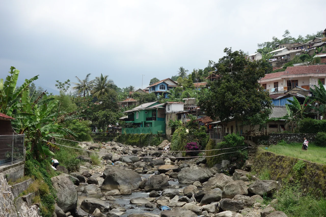
A River in Crisis
Modern Jakarta's relationship with the Ciliwung is one of mutual punishment. Informal settlements crowd the banks, reducing the river's surface area and choking canals with waste. Upstream, the forests around the Puncak area that once absorbed monsoon rains have been converted to settlements, worsening floods with each passing year. A 2014 audit found seventeen separate companies polluting the river's waters. The government has responded with ambitious plans: a 2012 announcement laid out a 20-year cleanup beginning with a $10 million restoration project. A 2.9-kilometer tunnel connecting the Ciliwung to the Cisadane River was planned to relieve flood pressure. Restoration work along 19 kilometers from Manggarai to South Jakarta aims to widen the channel from 25 meters to as much as 50, nearly tripling water flow capacity. More than 4,000 workers now clean Jakarta's waterways regularly. Whether engineering and labor can undo centuries of transformation remains the Ciliwung's open question.
Two Cultures, One River
The Ciliwung bisects two worlds. In its southern reaches through West Java, Sundanese culture dominates: the sensual Jaipongan dance, the bamboo resonance of angklung and calung, the metallic shimmer of gamelan degung. In northern Jakarta, Betawi culture takes over with the Yapong dance, the hybrid sound of gambang kromong, and the comic theater of Lenong performed in the local dialect. Kroncong music, that Portuguese-influenced genre carried to Indonesia centuries ago, still echoes near Tugu in north Jakarta. The river connects these cultures the way it always has - not by blending them, but by flowing through both, carrying the sediment of each downstream.
From the Air
The Ciliwung is visible from the air as a winding watercourse running roughly north from the volcanic highlands near Bogor (approximately -6.694 lat, 106.969 lng) to Jakarta Bay. Its upper reaches pass near Mount Salak (ICAO: none nearby - use Atang Senjaya/WIHB at Bogor or Halim Perdanakusuma/WIHH in Jakarta). The river threads through dense urban fabric in Jakarta, where its canalized sections are visible as straight channels amid the city grid. Soekarno-Hatta International Airport (WIII) lies roughly 25 km west of the river's mouth. Best observed at moderate altitude to trace the full course from highland to coast.
Nearby Stories
- Battle of Tjiater Pass 6.1 km away
- Citarum River 21 km away
- Where Incense Meets Incantation 24 km away
- Kawah Putih 42 km away
- The Crossing at Silebu 48 km away
- The Scholar's Mosque 89 km away
- The Islands That Vanished from Sight 321 km away
- SIEV X 351 km away