Coxcomb Mountains
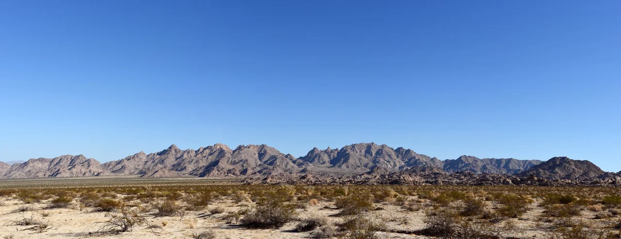
Joshua Tree National Park is large enough to contain ranges that most of its visitors will never see. The Coxcomb Mountains occupy the park's eastern extremity — a corner of wilderness that the park's road system does not reach, where the Mojave Desert's elevation finally drops away into the lower, hotter Colorado Desert, and where the mountains themselves are described by the park service as the most rugged in the entire park.
The Roughest Corner
The Coxcomb Mountains rise to 4,482 feet at Spectre Peak, their highest point. The name Spectre suits terrain that is difficult to access and rarely visited — a place that exists at the edge of the park's mapped trails and organized facilities. The mountains are built from ancient rock that the desert has fractured into forms more severe than the rounded granite boulder fields that define the park's western landscapes.
The range lies entirely within Joshua Tree National Park, but the park's infrastructure — roads, campgrounds, ranger stations, the facilities that most visitors use — is concentrated in the western and central portions. The Coxcombs are at the far end of a park that already covers 1,235 square miles. Getting to them requires intention and preparation. Few people do.
Where Two Deserts Meet
The Coxcomb Mountains sit in an ecotone — a transition zone between two distinct desert ecosystems. To the north and west, at higher elevations, the Mojave Desert brings Joshua trees, scrub oaks, and the cooler temperatures that allow larger plants to establish. To the south and east, the terrain drops into the Colorado Desert, a subdivision of the Sonoran Desert that is lower, hotter, and dominated by different plants — ocotillo, cholla cactus, ironwood, and palo verde.
The Coxcombs occupy the boundary of this transition. On their slopes, the two communities intermingle and compete, with elevation and aspect determining which plants succeed. This ecotone character makes the mountains ecologically interesting — a place where two different desert worlds meet — even as the ruggedness makes them difficult to explore.
The Wildest Reach
Park service descriptions of the Coxcomb Mountains consistently emphasize what they lack: maintained trails, reliable water, easy access, other people. The wilderness designation that covers this portion of the park preserves the terrain from development, which is not a difficult task when the terrain discourages human presence on its own terms.
For pilots crossing the region, the Coxcombs mark the eastern edge of the national park's protected airspace and the transition from the park's terrain to the open desert of the lower Colorado basin. The mountains' distinctive profile — more fractured and jagged than the boulder fields to the west — makes them identifiable from altitude. Spectre Peak is the highest point in the eastern park, visible against the flat desert plains that extend toward the Colorado River.
From the Air
The Coxcomb Mountains occupy the eastern portion of Joshua Tree National Park, centered around 33.90°N, 115.60°W. Spectre Peak at 4,482 feet is the highest point in the eastern park. The terrain transitions visibly from rough mountain to flat Colorado Desert floor east of the range. Restricted airspace over Joshua Tree National Park — check NOTAMs. Nearest airports: Thermal/Jacqueline Cochran Regional (TRM) ~35 miles south, Blythe Airport (BLH) ~50 miles east.
Nearby Stories
- Desert Queen Mine 5.2 km away
- Sidney Garfield 8.9 km away
- Coachella Valley Water District 17 km away
- Bristol Lake 27 km away
- Bagdad-Chase Mine 33 km away
- Poston War Relocation Center 52 km away
- London Bridge (Lake Havasu City) 60 km away
- Laguna Diversion Dam 108 km away