Bristol Lake
Bristol Lake is dry, most of the time — a playa, in the geological term for a flat basin that holds water episodically and evaporates it almost immediately. The lake bed is white with salt, arranged in a pattern that reflects the underlying geology: a bullseye of mineral rings, halite at the center, then mud, then gypsum, then sand at the margins. Each ring marks a different chemistry, a different depth to which ancient water once stood. Walk from the edge toward the center and you walk backward through the history of evaporation.
The Salt Business
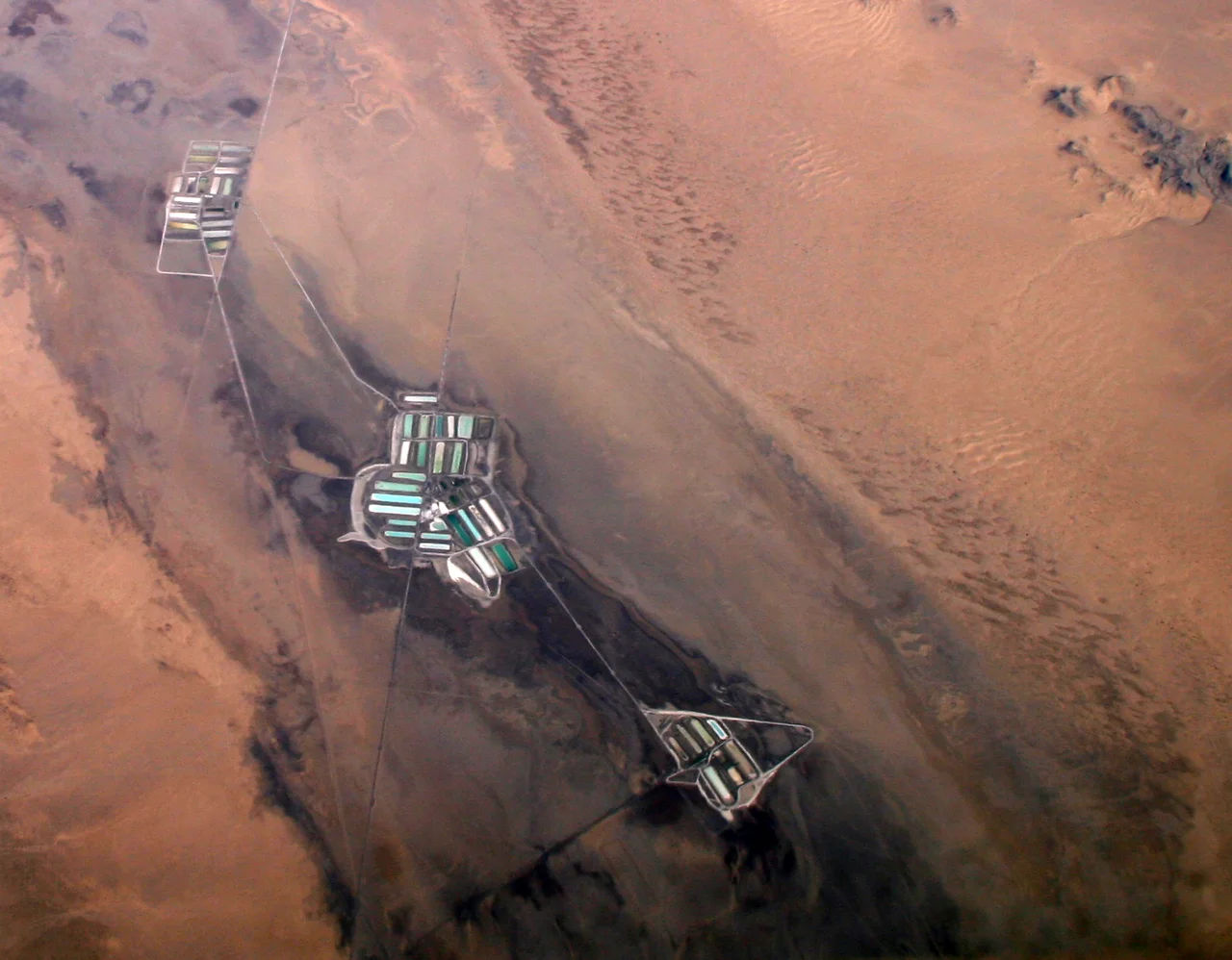
Salt evaporation operations have extracted minerals from Bristol Lake for well over a century. The industrial apparatus — evaporation ponds, processing equipment, access roads — occupies part of the lake bed, a working industrial site in the middle of a landscape that otherwise sees almost no development. The operation takes advantage of what the desert's fundamental conditions — extreme heat, low humidity, abundant sunshine — produce naturally: concentrated minerals left behind when water vanishes.
The lake is the northernmost in a chain of playas that includes Cadiz Lake and Danby Lake, each occupying a separate basin in the eastern Mojave lowlands. Together they form a playa system that captures whatever runoff makes it this far from the surrounding mountains — which is very little, and very rarely.
The Mineral Bullseye
The concentric mineral pattern that makes Bristol Lake distinctive from the air is a textbook example of evaporite geology. When a saline lake evaporates, minerals precipitate in sequence according to their solubility — the least soluble precipitate first and settle in the outer rings, while the most soluble concentrate toward the center and precipitate last. At Bristol Lake, this means sand and gypsum at the margins, then mud, then halite at the center.
The pattern is preserved because the lake doesn't fill deeply or frequently enough to disturb the mineral layers already deposited. Each evaporation cycle adds to the existing pattern, reinforcing the rings rather than mixing them. Scientists studying ancient climate use these mineral layers as proxies for past rainfall patterns — the thickness and composition of each layer recording how wet or dry a given period was.
Magma Hints Below
The brines that seep into Bristol Lake from beneath contain calcium chloride — an unusual geochemical signature that suggests something remarkable: a possible magma chamber lurking at depth. Calcium-chloride brines typically form through water-rock interactions at high temperatures, which in this setting implies that the crust beneath the playa is being heated from below.
If the interpretation is correct, Bristol Lake sits above a system that connects surface geology to deep crustal processes. The volcanic features visible elsewhere in the eastern Mojave — Amboy Crater's cinder cone, the lava fields that dot the landscape — suggest the region has not finished with its volcanic history. The brines at Bristol Lake may be one signal of what is still happening far beneath the salt flat.
The Playa's Character
From above, Bristol Lake is a white oval in a tan landscape — conspicuous, geometrically simple, almost abstract in its flatness. At ground level it is less inviting: the salt crust can be treacherous, yielding underfoot into muddy sediment, and the surface reflects heat with an efficiency that can be genuinely dangerous in summer.
The industrial salt operation breaks the playa's natural uniformity with ponds and berms that are visible from the air. The surrounding terrain — alluvial fans, desert pavement, scattered creosote and saltbush — fades into the Clipper Mountains to the north and the Bristol Mountains to the south. The lake has no outlet. What comes in, stays, until the sun takes it.
From the Air
Located at 34.462°N, 115.674°W in eastern San Bernardino County. The white playa and its concentric mineral rings are clearly visible from the air, with industrial salt ponds breaking the natural surface. The lake is approximately 23 kilometers east to west. Nearest airport: Twentynine Palms Airport (TNP), approximately 50 miles southwest.
Nearby Stories
- Landers 2.7 km away
- Granite Mountains (Eastern San Bernardino County) 7.6 km away
- Wonder Valley, California 18 km away
- Lavic Lake Volcanic Field 21 km away
- Camp Cady 26 km away
- London Bridge (Lake Havasu City) 89 km away
- Poston War Relocation Center 90 km away
- Boulder City and Hoover Dam 138 km away