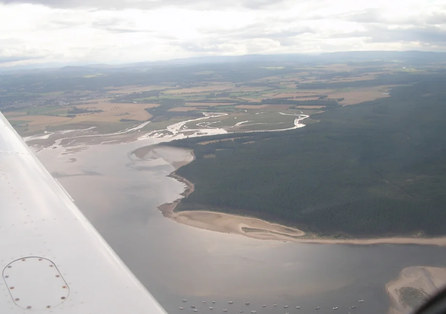

Culbin Sands, Forest and Findhorn Bay
Stand in the Culbin Forest today and you stand on what was, until the 1920s, the largest dune system in Britain. The forest is younger than the people who planted it: from 1922 onward the Forestry Commission set pine into shifting sand across more than 2,500 hectares, working for over four decades to anchor what had been one of the most restless landscapes in Scotland. Now Culbin runs in a long strip along the Moray Firth between Nairn and Findhorn Bay, designated a Site of Special Scientific Interest and managed by Forestry and Land Scotland. The forest meets a beach owned by the RSPB. The beach meets a tidal basin called Findhorn Bay that is not actually a bay. And somewhere underneath, the story goes, lies a buried village.
The Buried Village of Culbin
A community once existed northeast of the present forest, though no-one is sure exactly where. Folklore says the village was buried in sandstorms in 1694, swallowed in a single catastrophic season. The contemporary news records do not actually mention any such event, and modern historians have grown skeptical of the dramatic version. What records do mention, preserved at the Local Heritage Centre in Elgin, is something quieter and ultimately more damning: the village had deforested the Culbin lands, the land between the village and the mainland destabilized, and the sea slowly corroded what was left until the settlement was lost. The same pattern affected Findhorn village further east - the original site extended further north into the sea and was eventually given up. The lesson the surviving locals drew from all this was practical. When the marram grass that anchored the dunes started being cut for thatching, the dunes began to walk again, swallowing homesteads. Stabilization, when it finally came, took decades.
The Forest That Grew Over the Dunes
Culbin Forest is not a pristine wilderness. It is an engineering project that turned into an ecosystem. Tall pines dominate, but there are sandy openings where younger trees have been planted, grassland patches that suit butterflies, and ponds that function as oases for the local animals. Hill 99 - a wooden viewing tower built to blend into the canopy - lets you see what you walked through. Crested tits breed here, an uncommon Highland specialty. The forest is also the most important British site for the Kentish glory moth, a striking species whose larvae feed on young birch saplings under three meters tall. The moths follow the timber felling around the forest, exploiting the patches of regeneration that forestry work creates. The adults can be seen in April and May. It is one of those quiet conservation stories where the work of managing the forest accidentally produces ideal habitat for something rare.
The Beach, the Bar, and the Geese
The RSPB owns the beach that fronts the forest. Eurasian oystercatchers, curlews, and redshanks work the wet sand. Driftwood collects in lines from winter storms. Three sand spits enclose a salt marsh called The Gut, and the largest spit - The Bar - is the longest of its kind in Scotland. Westward toward Nairn the beach hosts a wintering population of pale-bellied brant geese, one of only two such populations in Scotland; these birds belong to the Svalbard population, having flown south from the Arctic. In 1888 and 1889, by some accident of wind and weather, the dunes hosted breeding pairs of Pallas's sandgrouse - a Central Asian bird whose appearance in Scotland was a once-only event. It has never bred here since.
Findhorn Bay's Tidal Theatre
The bay is not really a bay. It is a large tidal basin enclosed by the villages of Kinloss and Findhorn to the east and Culbin Forest to the west, drained by the River Findhorn and the Muckle Burn. Most of the basin is shallow - two meters on average - with a deeper channel reaching ten meters where it opens to the Moray Firth. The combination of safety and shelter makes it ideal for amateur sailors and windsurfers. Opposite Findhorn village, a mixed colony of grey and common seals hauls out on the beach. Common eiders work the offshore waters. In winter, the bay holds a roost of at least 10,000 pink-footed geese - a number that makes a noticeable contribution to the global population and that produces predictable tensions between fowlers who hunt them and animal lovers who do not.
From the Air
Culbin Sands and Findhorn Bay stretch along the Moray Firth between Nairn (west) and Findhorn village (east), centered near 57.63N, 3.73W. The forest is a distinctive dark green strip 5 to 7 miles long; Findhorn Bay shows as a roughly circular tidal basin 2.5 miles across with a narrow outlet to the Firth. Inverness Airport (EGPE) lies 15 nm west; RAF Kinloss (former, now Kinloss Barracks) is immediately south of the bay. Best viewing 2,500 to 4,500 feet AGL. Low tide reveals dramatic sand patterns in the bay; high tide hides them.
Nearby Stories
- Black Isle 2.8 km away
- Strathspey Railway (preserved) 5.7 km away
- Tarbat Ness Lighthouse 6.2 km away
- Gordon Castle 7.4 km away
- Bonar Bridge 9.7 km away
- Loch Ness Monster 14 km away
- Kildrummy Castle 17 km away
- Battle of Tannach 65 km away