The Lotus That Broke: Cyclone Seroja's Path Across Two Nations
The name means lotus in Indonesian -- a flower associated with purity, resilience, and rebirth. Cyclone Seroja offered none of those things. Born as a quiet tropical low off the coast of Timor on April 3, 2021, it drifted with deceptive slowness, dumping catastrophic rainfall on communities that had little warning and even less infrastructure to absorb it. By the time the storm died, at least 272 people were dead across three countries, more than 70,000 structures lay damaged or destroyed in Indonesia's East Nusa Tenggara province alone, and a small Australian town had been virtually flattened. Seroja became the third-deadliest tropical cyclone on record in the Australian region, behind only Cyclone Mahina in 1899 and the Flores cyclone in 1973.
Two Storms, One Catastrophe
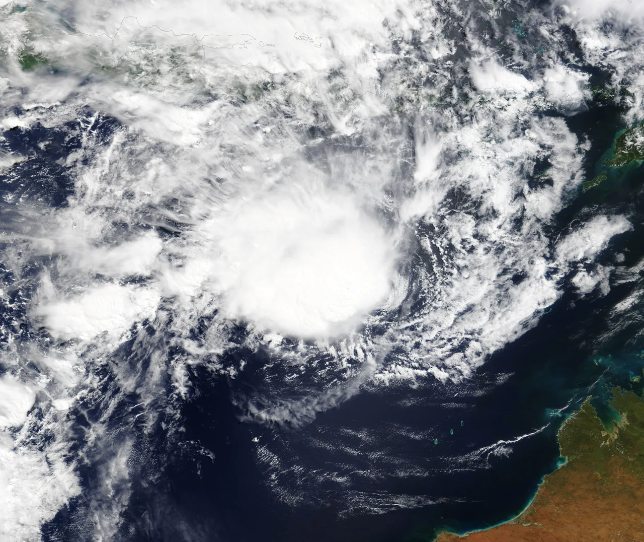
Seroja's meteorological story is unusual. As it drifted west-southwest from Timor, another tropical cyclone, Odette, was spinning to the northwest. The two storms began to interact through the Fujiwhara effect, a rare phenomenon in which nearby cyclones orbit each other rather than tracking independently. The interaction initially weakened Seroja, disrupting its structure and complicating forecasts. Then the balance shifted. Seroja began to absorb Odette, drawing in the smaller storm's moisture and energy until, by April 10, Odette ceased to exist as a separate system. Fed by its rival's remains and pushed southeast toward Australia, Seroja rapidly intensified. Within a day it had become a Category 3 severe tropical cyclone, with a ragged eye emerging from its dense cloud shield and wind gusts reaching 170 km/h. This kind of storm-eating-storm behavior is well documented in meteorology but rarely produces such devastating consequences on two continents.
Drowning in the Dry Season's Shadow
Before Seroja ever reached Australia, it had already wreaked havoc across Indonesia and East Timor. The storm moved slowly near Timor, its spiral rain bands pouring water onto steep terrain for days. In East Flores, a massive rockslide buried the village of Nelelamadike on Adonara Island, killing 55 people, 15 of them children. More than 600 residents of that single village were left homeless. Rivers burst their banks in Ende district. In Kupang, 734 houses sustained damage and a bridge connecting the city to Malaka Regency was destroyed, severing a critical transport link. A passenger ship sank in Kupang's port. Across East Nusa Tenggara province, the cyclone damaged or destroyed more than 20,000 houses and displaced over 11,000 people. In East Timor, flooding was described as the worst in 50 years, affecting 13 municipalities and destroying more than 4,200 houses. The country's central pharmacy, where COVID-19 vaccine stocks were stored, was damaged -- a blow compounding an already dire public health situation.
A Harvest Swept Away
For the farming communities of East Nusa Tenggara, one of Indonesia's poorest provinces, Seroja's most lasting damage was not to buildings but to food supplies. Residents reported more than 10,000 hectares of crops destroyed by floodwaters. In Malaka Regency, a major food-producing area, more than 4,000 hectares were lost, and the Benanain Dam's spillway collapsed, cutting off the main water source for local agriculture. Hundreds of livestock drowned. Seaweed farmers in Kupang Regency alone lost an estimated 7 billion rupiah in destroyed cultivation facilities. The Indonesian National Board for Disaster Management estimated preliminary losses across the province at 3.4 trillion rupiah -- roughly $236 million. These numbers describe an economic catastrophe in a region where many families already survived on one meal a day during lean months. The threat of food crisis rippled outward from the storm's path long after the winds subsided.
Landfall at the Edge of Memory
At around 8 p.m. on April 11, Seroja made landfall near the coastal town of Kalbarri in Western Australia, the first cyclone to strike this part of the coast since Cyclone Elaine in 1999. The region was unprepared. Homes were not built to cyclone standards. Residents had no living memory of winds this fierce. Within hours, 70 percent of structures in Kalbarri were damaged and 40 percent were completely destroyed. Northampton's shire president described the aftermath as though a bomb had gone off. Carnarvon's 124-year-old One Mile Jetty -- a beloved landmark -- collapsed and floated out to sea. More than 25,000 homes lost power. Some residents barricaded themselves in bathrooms and closets as roofs were torn away above them. Premier Mark McGowan called it "like nothing we have seen before in decades." The cyclone was declared an insurance catastrophe, and damage estimates reached 200 million Australian dollars. Recovery in the small affected towns was expected to take years.
The Name Retired
In the aftermath, Indonesia mobilized a massive relief effort. Navy hospital ships steamed toward the affected coast. Helicopters dropped food into remote villages while sniffer dogs searched for the missing. Provinces across the archipelago sent aid: West Sumatra contributed 1.5 tons of rendang, Central Java donated hundreds of millions of rupiah, and ordinary Indonesians raised nearly a billion rupiah within days. But criticism was sharp. Environmental groups and citizens attacked the slow government response. The hashtag #PrayforNTT went viral. The head of East Nusa Tenggara's disaster mitigation agency was fired, as was his counterpart in Kupang. The Prosperous Justice Party criticized President Joko Widodo for attending a celebrity wedding instead of addressing the disaster. East Timor's prime minister called the flooding one of the most devastating events to strike the country in four decades. Because of the destruction Seroja caused, its name was permanently retired from the tropical cyclone naming list, replaced by Rambutan. The lotus was struck from the record.
From the Air
Seroja's formation area lies near 11.1S, 121.3E, south of Timor island in the waters between Indonesia and Australia. From cruising altitude, the Timor Sea and Savu Sea are visible between the Lesser Sunda Islands chain. Nearest major airport to the formation zone is El Tari International Airport (WATT) in Kupang, West Timor. The Australian landfall occurred near Kalbarri, Western Australia, with the nearest commercial airport being Geraldton Airport (YGEL). The cyclone's track ran roughly southwest then southeast across the Indian Ocean. Weather in the region is tropical with wet season November-April; cyclone season runs roughly November through April.
Nearby Stories
- Ordinary Hunger: Life on Savu Island 58 km away
- Sumba's Hidden Canopy 124 km away
- Indonesia's Southern Frontier: Rote Island 124 km away
- Ashmore and Cartier Islands 147 km away
- Sumba: The Sandalwood Island 190 km away
- Kupang 206 km away
- Ichthys Gas Field 313 km away
- Port Hedland 1019 km away