Ordinary Hunger: Life on Savu Island
The Savunese have a word for the lean weeks before the corn harvest: ordinary hunger. It is not a crisis. It is a season, as predictable as the dry winds that blow north from Australia and drain the island's streams to dust. Families eat cassava, sweet potato, forest yams, and whatever sugar they can tap from the lontar palms that dot the grasslands. One meal a day is common. Children grow thin. Then the rains return, the corn comes in, and ordinary hunger ends -- until next year. Savu sits midway between Sumba and Rote in Indonesia's East Nusa Tenggara province, a coral-fringed island of roughly 95,000 people where survival has always meant reading the weather with extraordinary precision and accepting what it refuses to give.
Rising from the Seafloor
Savu exists because two tectonic plates are in slow collision. The Indo-Australian Plate pushes northward beneath the Eurasian Plate, and the friction has built a submarine ridge of volcanic rock along the collision zone. The Savu Islands -- Rai Hawu, Rai Jua, and the uninhabited Rai Dana -- sit atop this ridge, rising at roughly one millimeter per year. The volcanoes that built them are extinct; the active ones burn on Flores, to the north. But the tectonic tension remains. In August 1977, a magnitude 8.3 earthquake struck 280 kilometers west-southwest of Rai Jua, sending a tsunami across Savu's coastal plain at Seba that reached as high as the airport. No one on Savu or Rai Jua was reported missing, but on the neighboring islands of Sumba and Sumbawa, 180 people died. The islands are geologically young, still being squeezed upward by forces that occasionally remind their inhabitants how provisional solid ground can be.
When the Rains Betray
Savu's climate is tropical savanna -- hot, wind-scoured, and profoundly seasonal. Between 82 and 94 percent of the island's annual rainfall arrives during the west monsoon, from roughly November to March. The rest of the year is bone dry. Mean annual rainfall is just 1,019 millimeters, modest even by savanna standards, and El Nino years can devastate. Farmers plant corn in late November or December, hoping for enough rain to carry the crop to a February harvest. If the rains falter, they replant. Most keep seed reserves for a second attempt; almost none can afford a third. When drought pushes the harvest back, ordinary hunger stretches into what the Savunese call extraordinary hunger. Livestock die or are sold to buy emergency food. People eat green papaya and tamarind seeds. Drinking water grows scarce and is fouled by animals crowding the remaining wells. Women and girls spend hours carrying water. Gastrointestinal disease spikes. The agricultural system is not broken -- the Savunese have managed this arid landscape for centuries through traditional clan agreements on land use and water distribution. But the margin for error is razor-thin.
Noses Pressed Together
Savu society is layered in ways that colonial administrators and visiting scientists never fully mapped. The island's animistic tradition, Djingi Tiu, persists alongside the Protestantism that Dutch missionaries introduced centuries ago. When Savunese meet, they press their noses together simultaneously -- a greeting similar to the Maori hongi of New Zealand, used in formal encounters and major ceremonies alongside the Western handshake. Traditional clan structures still govern land allocation, garden management, and the careful ecology of mixed planting that the Savunese use to hedge against unpredictable rains. Their gardens mimic tropical forest, with diverse layers of trees and shade plants that hold moisture and protect soil. Cotton is the primary crop on the smaller island of Rai Jua, where women weave traditional textiles from locally grown fiber. In 2008, the three islands were organized into the Sabu Raijua Regency, a formal administrative structure overlaid on social patterns that predate European contact by centuries.
The Dutch, the Captain, and the Fortress
Europeans first encountered Savu through the Dutch East India Company in 1648, and early references to the island mostly concern Savunese soldiers, mercenaries, and enslaved people pressed into colonial service. In 1674, the crew of a Dutch sloop was killed in East Savu after their ship ran aground. The Dutch retaliated by allying with the raja of Seba and sending troops -- but they could not breach the fortress of Hurati in B'olou Village, which was protected by three concentric defensive walls. Unable to take it by force, the Dutch accepted payment in enslaved people, gold, and beads, and declared the matter settled. A century later, in 1770, Captain James Cook stopped at Savu for three days during his first Pacific voyage. Botanists Joseph Banks and Daniel Solander, the first scientists to sail on a European exploration, collected specimens and produced detailed records of the island. Much of their information, however, came secondhand from Mr. Lange, the German representative of the Dutch East India Company stationed on Savu -- a filter that shaped what Europe would believe about the island for generations.
A Sea Worth Protecting
The waters surrounding Savu are among the most biologically rich in Indonesia. In 2009, the Indonesian government established the Sawu Sea Marine National Park, encompassing 3.5 million hectares of ocean across multiple regencies. Within its boundaries lie more than 63,000 hectares of coral reef supporting 500 species of coral, along with mangroves, sea grass beds, and estuaries. Five of the world's six sea turtle species swim these waters. Thirty species of marine mammals have been documented here, including endangered sperm whales and blue whales. For the Savunese, the sea has always been both livelihood and boundary. Japanese interests introduced seaweed farming in the early 1990s, adding a new cash crop to an economy built on corn, rice, fishing, and livestock. From the air, Savu appears as a low, palm-dotted island rimmed by reef and sandy beach, surrounded by deep blue water that conceals one of the planet's great marine ecosystems -- and the tectonic seam that brought the island into existence.
From the Air
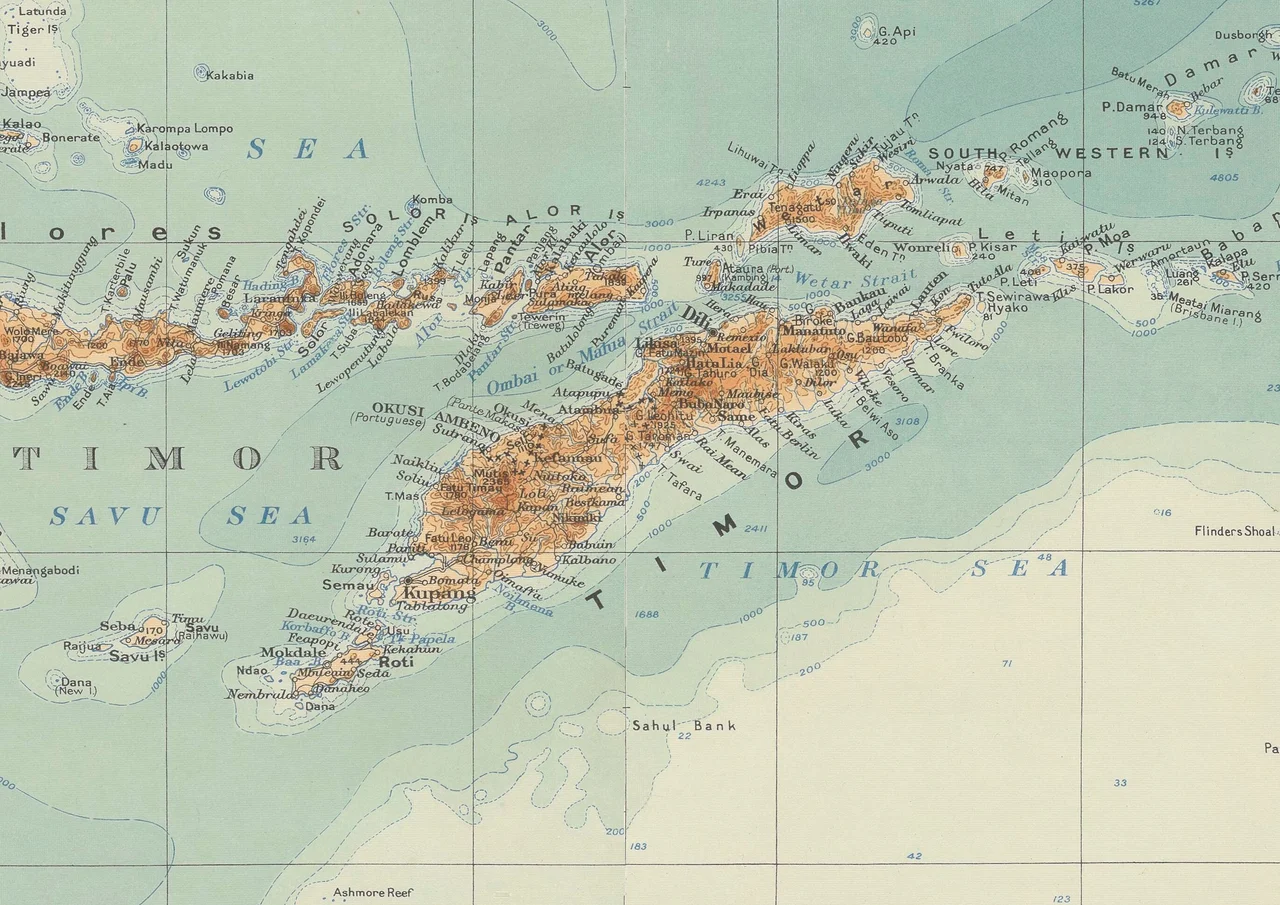
Savu is located at approximately 10.54S, 121.85E, midway between Sumba and Rote in the Lesser Sunda Islands chain. The island is visible from cruising altitude as a low, palm-covered landmass fringed by coral reefs and sandy beaches. Nearest major airport is El Tari International Airport (WATT) in Kupang, West Timor, approximately 200 km to the east. Savu has a small airstrip served by Susi Air. The Savu Sea lies to the north and the Timor Sea to the south. Rai Jua is visible as a smaller island to the west. Weather is tropical savanna with a pronounced dry season April-October; best visibility during dry months.
Nearby Stories
- The Lotus That Broke: Cyclone Seroja's Path Across Two Nations 70 km away
- Indonesia's Southern Frontier: Rote Island 85 km away
- Sumba's Hidden Canopy 122 km away
- Kupang 135 km away
- Lesser Sunda Islands 140 km away
- The Lakes Where Souls Go to Rest 160 km away
- Sumba: The Sandalwood Island 163 km away
- Port Hedland 1104 km away