Lesser Sunda Islands
Between Bali and Lombok -- two islands separated by only 35 kilometers of water -- the natural world changes more dramatically than across entire continents. The Lombok Strait runs deep, and it ran deep even during ice ages when lower sea levels welded Bali to the Asian mainland. Alfred Russel Wallace noticed this in the 1850s, describing a boundary so sharp that Asian barbets and woodpeckers on Bali gave way to Australasian cockatoos and honeyeaters on Lombok. The line that bears his name passes right through the Lesser Sunda Islands, also known as Nusa Tenggara -- the 'Southeast Islands' in Old Javanese. This volcanic archipelago, curving east from Bali through Lombok, Sumbawa, Flores, Sumba, and Timor, sits at the collision zone of two tectonic plates, two biological realms, and centuries of competing colonial ambitions. More than 17 million people live here now. So does the world's largest lizard.
Born from Collision
The Lesser Sundas exist because the Australian and Eurasian plates have been grinding into each other for roughly 15 million years. The collision produced the Sunda Arc, a chain of volcanic islands formed by subduction along the Sunda Trench in the Java Sea. The northern chain -- Bali, Lombok, Sumbawa, Flores, Wetar -- is volcanic in origin, studded with peaks both active and extinct. Mount Rinjani on Lombok still erupts; Ilikedeka on Flores has gone quiet. The southern islands, including Sumba and Timor, are non-volcanic, built from uplifted coral and sedimentary rock. The geology is among the most complex on the planet, and theories about the islands' formation shifted significantly during the late twentieth century. Scientists are still piecing together the sequence. What is certain is that these islands sit at a restless boundary -- earthquakes, volcanic eruptions, and landslips are not interruptions to life here but part of its rhythm.
Wallace's Invisible Wall
The Wallace Line is one of the most important concepts in biogeography, and the Lesser Sundas are where it becomes visible. During glacial periods, lower sea levels connected Bali to Java, Sumatra, and the Asian mainland -- a vast landmass called Sundaland. Elephants, tigers, and other large Asian mammals roamed freely across it. But the Lombok Strait's deep waters remained an impassable barrier, even at the lowest sea levels. East of that line lies Wallacea, a transitional zone where Asian and Australasian species mingle in proportions that shift island by island. Asian species still predominate in the Lesser Sundas -- Weber's Line, marking the shift to majority Australasian fauna, runs east of the group. Bali once hosted Asian elephants and the now-extinct Bali tiger. Lombok, just across the strait, never had either. The deep oceanic trenches between the islands limited the movement of flora and fauna, producing an unusual number of localized species -- seventeen endemic birds among the 273 found on the northern islands alone.
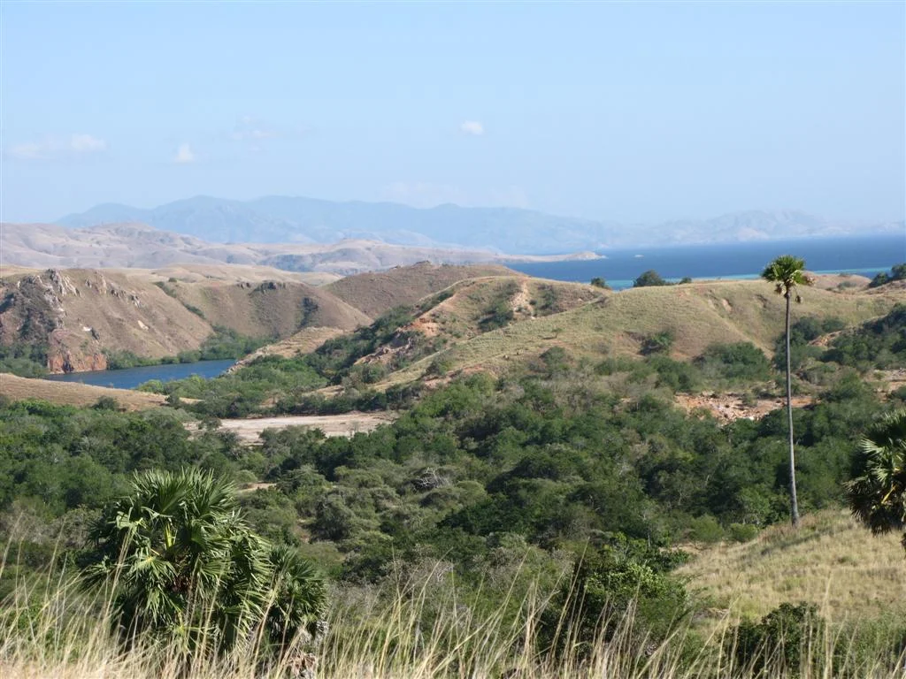
Kingdom of the Dragon
The most famous resident of the Lesser Sundas needs no introduction, though its dimensions bear repeating: three meters long, ninety kilograms, carnivorous. The Komodo dragon survives on just five islands -- Komodo, Rinca, Gili Motang, Gili Dasami, and the northwestern coast of Flores. It is the world's largest lizard, a relic of a time when megafauna were more common across Australasia. The dragon's habitat is the Lesser Sundas deciduous forest, a dry landscape of savanna grasses and Borassus palms very different from the lush rainforests most people associate with Indonesia. These islands have the driest climate in the archipelago, and tropical dry broadleaf forests dominate where tropical moist forests would grow elsewhere. Komodo, Rinca, and Padar are now protected as Komodo National Park, but beyond the park boundaries, more than half the original vegetation across the Lesser Sundas has been cleared for rice, settlement, and the fires that follow. Only Sumbawa retains a large area of intact natural forest.
Islands of Isolation
Small islands breed specialization and vulnerability in roughly equal measure. The Lesser Sundas' endemic mammals include the endangered Flores shrew, the vulnerable Komodo rat, and the Lombok flying fox -- species that evolved in isolation on islands where a single cyclone or forest fire can eliminate a significant portion of habitat. The ecology is fragile in ways that larger landmasses can absorb. Catchment areas are small and erosion is high. A greater proportion of each island is coastline, exposing more territory to storm damage. Development pressures are increasing, though their effects are not always predictable. The human communities, too, developed in relative isolation, retaining distinct cultural identities across remarkably short distances. Societies on neighboring islands sometimes speak mutually unintelligible languages. Economic migration increasingly draws young people away from smaller islands toward provincial capitals like Kupang and Mataram, hollowing out communities that have persisted for centuries.
Divided by Decree
Politically, the Lesser Sundas trace an equally complicated arc. From 1945, the Indonesian government administered the islands as a single province called Sunda Kecil -- 'Lesser Sundas' -- later renamed Nusa Tenggara. In 1958, this was split into three provinces: Bali, West Nusa Tenggara, and East Nusa Tenggara. The eastern half of Timor is a separate nation entirely -- East Timor, or Timor-Leste, which won independence from Indonesia in 2002 after a brutal occupation that began with the 1975 invasion. The administrative divisions overlay a cultural mosaic that no boundary quite captures. Hindu Bali shares an island chain with predominantly Christian East Nusa Tenggara and predominantly Muslim West Nusa Tenggara. The old Javanese etymology of 'Nusa Tenggara' -- 'Southeast Islands' -- is accurate enough geographically, but it understates the diversity packed into this chain of land between two oceans and two continents.
From the Air
The Lesser Sunda Islands stretch from approximately 8°S, 115°E (Bali) to 10°S, 127°E (Timor) in eastern Indonesia. From altitude, the island chain is clearly visible as a string of mountainous landmasses curving eastward from Java, separated by deep blue straits. Key visual landmarks include Mount Rinjani (3,726m) on Lombok, the distinctive shape of Komodo Island, and the large island of Timor at the eastern end. Major airports along the chain: Ngurah Rai/Bali (WADD), Lombok International (WADL), Sultan Muhammad Salahuddin/Bima (WADB), Komodo/Labuan Bajo (WATO), El Tari/Kupang (WATT). Recommended altitude: 15,000-25,000 feet to see the full arc of the island chain and appreciate the geological structure. The Wallace Line passes through the Lombok Strait between Bali and Lombok.
Nearby Stories
- Indonesia's Southern Frontier: Rote Island 65 km away
- Ordinary Hunger: Life on Savu Island 133 km away
- The Night the Mountain Fell into the Sea 139 km away
- The Husband Who Will Not Be Quiet 149 km away
- Solor: The Island That Empires Fought Over and Forgot 182 km away
- Montara Oil Spill 270 km away
- Mungalalu Truscott Airbase 507 km away
- The Banda Sea: Where Continents Collide 605 km away