Solor: The Island That Empires Fought Over and Forgot
In 1598, the Portuguese needed ninety warships to suppress a single island. Not a continent, not a kingdom - an island forty kilometers long and six wide, studded with five volcanoes and home to a people who had been hunting whales since before Lisbon knew the route around Africa. Solor sits off the eastern tip of Flores in Indonesia's Lesser Sunda chain, a sliver of volcanic rock in waters so remote that colonial powers fought bitterly to possess it and then, repeatedly, decided it was not worth keeping.
Sandalwood and the Spice of Empire
What drew Europeans to this improbable place was sandalwood. Since at least the 1500s, Solor had served as a safe harbor along the sandalwood trade routes that connected the fragrant forests of Timor with markets in China and India. Portuguese Dominican friars arrived first, building a stone fortress and converting thousands - by 1590, the Portuguese and Christian population numbered roughly 25,000 on this narrow island. But conversion did not mean submission. The Solorese resisted both the Portuguese crown and the cross, and the 1598 uprising required that armada of ninety ships to suppress. The conflict ran deeper than religion: traders and priests fought each other almost as fiercely as they fought the islanders. When the tension became unbearable, the merchants abandoned Solor entirely and relocated across the strait to Larantuka on Flores, leaving the priests to manage an island they could barely hold.
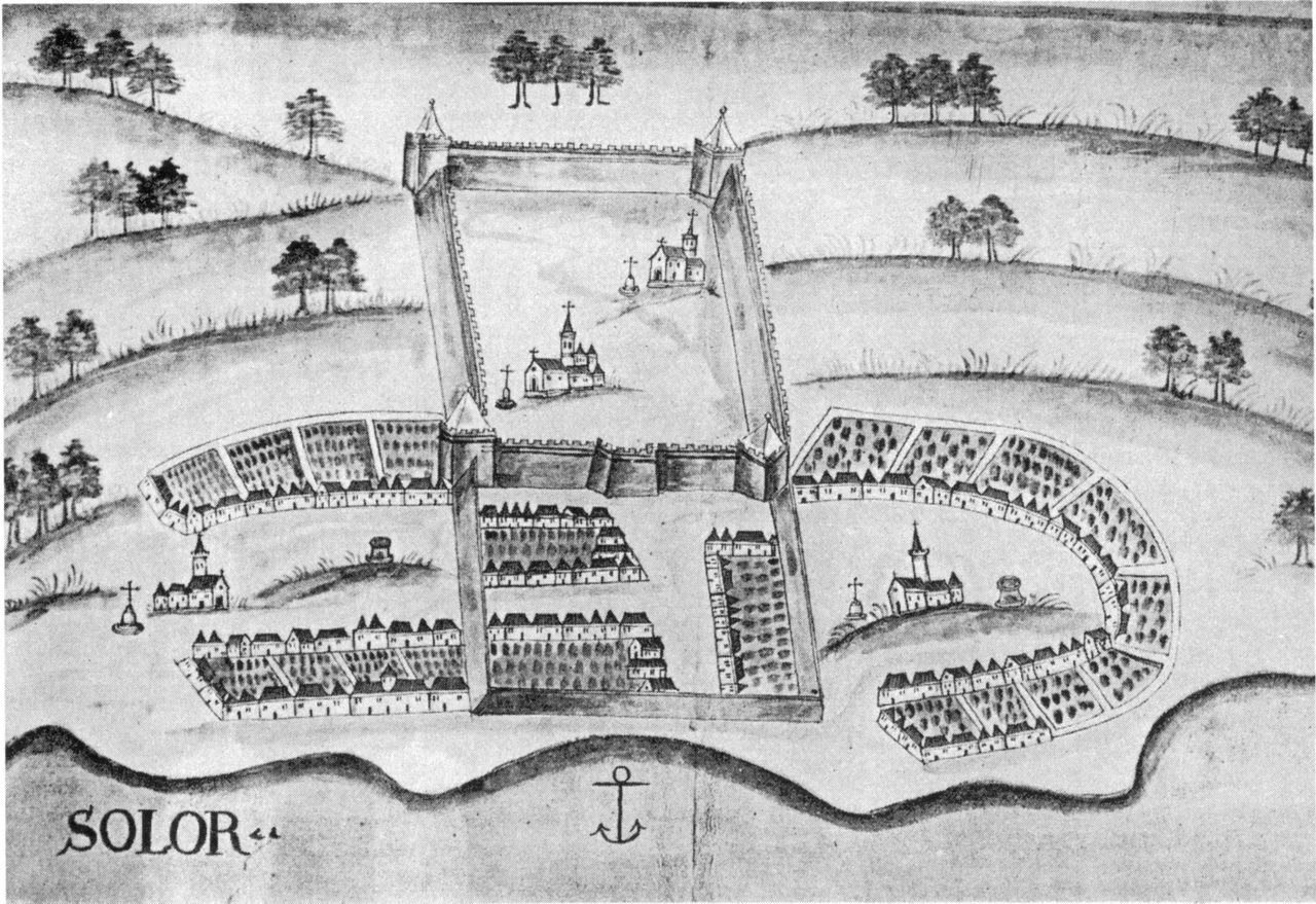
A Fort That Changed Hands Like Currency
The Dutch arrived in 1613, and the priests surrendered at the first assault. They too were sent to Larantuka. What followed was a decades-long farce of colonial musical chairs. The Dutch garrisoned the Portuguese fort but could not turn a profit. Two Dutch commanders defected to the Portuguese side, and the Netherlands abandoned Solor. The Portuguese returned. In 1636, the Dutch attacked again, seizing the fort. They lost it, retook it in 1646, and promptly ran into trouble: one commander was suspended for marrying a local woman, and his successor challenged the Portuguese commander to a duel and was killed. By 1648, the Dutch gave up once more, and the Dominican priests crept back to their fortress. The ruins of that much-contested stronghold - built, besieged, abandoned, and reoccupied across two centuries - remain visible on the island today.
Sold Without Permission
The final colonial transaction was as absurd as what preceded it. In 1851, the Portuguese governor in the region simply sold Solor and other Lesser Sunda territories to the Netherlands for florins - without bothering to ask Lisbon. When the capital found out, they had Governor Lopes arrested. He died on the voyage back to Europe, never standing trial. The negotiations dragged on for years, but the sale was eventually confirmed by the Treaty of Lisbon in 1859. Even then, the Dutch barely maintained a presence. They stationed a small garrison, withdrew it in 1869 for cost reasons, and kept only a paper claim. Japanese forces occupied the island from 1942 to 1945, and after independence Solor became part of the Republic of Indonesia, administered by the East Flores Regency.
Whalers on a Volcanic Shore
Through all the colonial comings and goings, the Solorese carried on with what they had done for centuries: hunting whales. The people of Lamakera and other coastal villages practice traditional whaling that predates European contact, passing down techniques and rituals across generations. They speak languages from the Lamaholot and Adonara families, tongues shaped by this archipelago's isolation and maritime culture. Today some 36,000 people live on Solor, spread across three administrative districts and dozens of villages with names like Lewohedo, Wulublolong, and Karawatung. Five volcanoes rise from the island's spine, making the terrain as dramatic as its history. Life here remains shaped by the sea - by fishing, by the tides, by the same winds that once filled the sails of sandalwood traders and colonial warships alike.
From the Air
Solor lies at approximately 8.48°S, 122.98°E, a narrow volcanic island visible east of Flores across a slim strait. At cruising altitude, the island's elongated shape - 40 km long but only 6 km wide - is unmistakable, with five volcanic peaks along its ridge. The strait between Solor and Flores makes a useful visual navigation reference. The nearest significant airfield is Frans Seda Airport (WATL) at Maumere on Flores, approximately 100 km to the west. Larantuka on the eastern tip of Flores is visible across the water.
Nearby Stories
- The Night the Mountain Fell into the Sea 14 km away
- Five Minutes After the Shaking Stopped 50 km away
- The Month the World Didn't Know 97 km away
- Kupang 154 km away
- Lesser Sunda Islands 172 km away
- Ordinary Hunger: Life on Savu Island 202 km away
- The Bluff That Worked and the Storm That Didn't Care 240 km away
- Wakatobi: Four Islands, One Name 306 km away