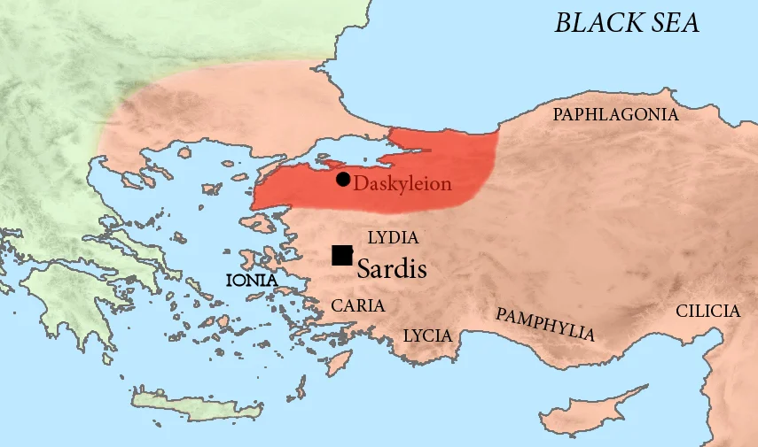

Dascylium
The name Dascylium is said to derive from Dascylus, the father of Gyges — Gyges who would become king of Lydia, one of the ancient world's wealthiest rulers. Whether that naming tradition is history or myth is hard to say, but it establishes the site's pedigree early: this was already a significant place before the Phrygians settled here before 750 BC, before the Lydians absorbed it, and long before the Persians made it the administrative capital of their westernmost Asian satrapy. The site at modern Ergili, about 30 kilometers inland from the coast of the Propontis near Bandırma, was rediscovered in 1952 and has been under excavation since. What the digging has produced is a layered record of Bronze Age habitation, Phrygian and Lydian occupation, Persian imperial administration, Greek cultural overlay, early Christian church life, and ongoing revelation — including a terracotta mask of Dionysus and a stone relief depicting Greek-Persian battles, both found in the 21st century.
Capital of a Persian Satrapy
For roughly two centuries, from the mid-6th century BC until Alexander's conquest in 334 BC, Dascylium served as the seat of the satrapy of Hellespontine Phrygia — one of the major Persian administrative provinces governing the western edge of the Achaemenid Empire. The satrapy's territory encompassed a large swathe of northwestern Anatolia, including the Troad, Mysia, and Bithynia. Persian satraps governed from here, maintaining the empire's presence on the edge of the Greek world, collecting tribute, and managing the complex politics of a region where Persian power met Greek city-states and Thracian kingdoms. The satrapal court at Dascylium would have been a significant place: Persian administrative practice typically included elaborate residential compounds, reception halls, gardens, and the full apparatus of provincial imperial government. Archaeological work at the site has been confirming this gradually. Arsites, the satrap of Hellespontine Phrygia in 334 BC, was the last Persian governor here before Alexander's arrival ended Persian rule in the region — Arsites committed suicide following the Persian defeat at the Granicus.
Alexander Passes Through
In May 334 BC, after his victory at the Battle of the Granicus — fought, according to Arrian, on Alexander's route from Abydos on the coast toward Dascylium — Alexander the Great arrived at Dascylium and took control of the satrapal capital. The battle at the Granicus was the first major engagement of Alexander's Asian campaign, the moment when the Achaemenid Empire's ability to stop the Macedonian advance was tested and found wanting. Alexander replaced the Persian satrap with Calas, a Macedonian general, and the province changed hands. Calas was later replaced by Arrhidaeus in the Treaty of Triparadisus that divided Alexander's empire among his successors after his death. Dascylium was a member of the Delian League — the Athenian-led alliance that had extracted tribute from coastal and inland Anatolian cities in the 5th century BC — which suggests that even before Alexander, the city had moved between Persian and Greek spheres of influence as the balance of power in the Aegean shifted.
What the Archaeologists Found
The site lay unexcavated until 1952, when it was rediscovered and the modern excavation program began. From 1988 to 2010, the work was directed by the archaeologist Tomris Bakır, who established the stratigraphic record of the site's long occupation. The Bronze Age layer confirms habitation going back thousands of years before the Persian period. In 2020, a team working on the acropolis unearthed a terracotta mask representing the god Dionysus, dated to the 4th century BC — the period of Persian satrapal rule, when Greek religious imagery was circulating widely through the region's mixed cultural world. In August 2021, a team led by Kaan Iren announced the discovery of an ancient stone relief depicting the Greek-Persian wars. As Iren described it: there are Greek soldiers fighting and Persians on horseback fighting them, with Greek soldiers shown beneath the hooves of Persian horses. The scene, Iren said, is propaganda — the visual language of a ruling power asserting military dominance. That such a relief was made at Dascylium is itself a reminder of how the Persians and Greeks, so often cast as opposites, shared the same visual vocabulary of war and power.
Christian Diocese, Buried City
Long after the Persian satraps and Alexander's generals, Dascylium continued to exist as a functioning settlement, passing through Hellenistic, Roman, and Byzantine periods. By the mid-7th century AD, it appears in the Notitia Episcopatuum — a list of Christian dioceses — as a bishopric subordinate to the metropolitan see of Nicomedia, capital of the Roman province of Bithynia. The first bishop of Dascylium whose name appears in any surviving document is Ioannes, who attended both the Third Council of Constantinople in 680 and the Trullan Council of 692. Other bishops followed: a priest named Basilius represented an unnamed bishop at the Second Council of Nicaea in 787; Georgius attended the Council of Constantinople in 869; Germanus appeared at the Photian Council of Constantinople in 879. The city's presence in these church records means it remained an administrative and religious center deep into the Byzantine period. Then the records stop. The settlement faded, the buildings silted over, and the site slept under the fields near Ergili for centuries — until the spade work of the 20th and 21st centuries began to bring it back.
From the Air
Dascylium is located near modern Ergili at 40.132°N, 28.052°E, approximately 30 km inland from the southern shore of the Propontis (Sea of Marmara) near Bandırma. At 3,000–5,000 feet MSL, the site is visible as agricultural terrain east of Bandırma, with Kuş Gölü (Bird Lake, also known as Manyas Lake) prominent to the southeast as a navigation landmark — the lake and its wildlife sanctuary are clearly identifiable from altitude. The nearest airport is LTBG (Bandırma Airport), approximately 25 km to the northwest, making this one of the closer ancient sites to that field. The landscape here is low-lying agricultural plain near the lake margins, with little surface indication of the satrapal capital buried below.
Nearby Stories
- SS Memel / Ivan Sechenov 3.5 km away
- Kapıdağ Peninsula 8.9 km away
- Battle of the Granicus 17 km away
- Balıkesir 29 km away
- Edremit 48 km away
- Green Mosque of Bursa 51 km away
- 1509 Constantinople Earthquake 56 km away
- Antalya Museum 387 km away