Diamond Interchange: How a Simple Idea Reshapes Towns Like Julich
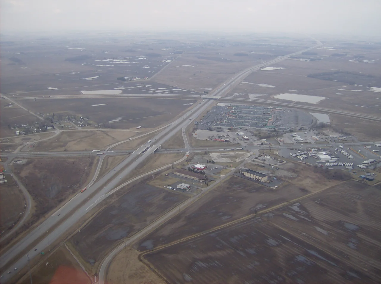
Trace the German autobahn east from Aachen on a sunny morning and somewhere near the small university town of Julich you will pass over an oddly geometric thing in the fields below: two roundabouts on either side of a bridge, connected by short ramps, the whole arrangement vaguely shaped like a bone. It was once a half-cloverleaf, looping ramps and merging lanes, but engineers ripped it out and replaced it with this leaner, simpler descendant. What you are looking at is one variation in a sprawling family of road junctions, all built on the same idea: the diamond interchange.
The Shape of a Crossing
A diamond interchange is the most economical way to let a controlled-access highway cross a smaller road. The freeway runs straight; the minor road passes over or under it on a bridge. Four short ramps angle off each side, meeting the smaller road at two ordinary intersections. From the air the off-ramps and on-ramps trace the four sides of a rough diamond, which is where the name comes from. There is no cloverleaf swirl, no interweaving, no flying flyovers, just two intersections and a bridge. Stand on the overpass and you can watch the whole geometry work in front of you in a way that most modern interchanges are too tangled to allow.
Why It Won
The diamond won out across most of the rural United States and a fair share of Europe for an unromantic reason: it takes less land and less concrete than almost anything else that does the same job. Where traffic is light, a stop sign at the foot of each off-ramp is enough; where traffic is heavier, traffic lights and turn lanes get bolted on. The classic form has obvious limits. Left turns block opposing traffic. Two signalized intersections in close sequence can choke a busy minor road. So engineers have spent the last forty years inventing variations: tight diamond, single-point urban, three-level diamond, split diamond, and the elegant trick of the diverging diamond, where the cross-street traffic briefly drives on the wrong side of the bridge so that no left turn has to cross oncoming traffic at all.
Roundabouts on Either Side
European engineers tend to reach for roundabouts where Americans reach for traffic lights, and the diamond family bent to fit. The dumbbell interchange replaces the two intersections with roundabouts, which gave Britain and Ireland their preferred form. The dogbone is a tighter version, with stretched teardrop roundabouts instead of full circles, named for what it looks like from a passing aircraft. The example near Julich, where the A44 autobahn crosses the L253, is a turbo dumbbell, a hybrid that adds spiraling lanes inside each roundabout to keep traffic from weaving across one another. It was retrofitted in place of an older half-cloverleaf and is a textbook example of how German road engineers have been quietly replacing the freeway designs of the 1960s and 70s with leaner, more compact descendants.
Local Variations, Local Tastes
The family tree branches in unexpected directions. Carmel, Indiana built a string of dogbone interchanges along Keystone Parkway to keep its parkway aesthetic intact. San Marcos, Texas pioneered the continuous-flow diamond, where displaced left turns merge into U-turn lanes borrowed from frontage roads. Perth, Western Australia tried a tennis ball interchange that lets right-turning cars cut through the roundabout rather than go around. The N7 in Groningen uses a hybrid with one roundabout and one teardrop. Every regional traffic culture has tinkered with the basic diamond template. Drive an old American interstate exit and a Dutch motorway junction back to back and you will see the same simple geometry expressed in two very different design languages.
Geometry You Can Read From the Air
From a passenger window the diamond and its cousins read like punctuation marks on the landscape. Two parallel ramps, a bridge, two roundabouts; a kite shape; a stretched bone; a single round signalized intersection at the heart of a soaring overpass. These shapes are usually the most visible human design feature for kilometers around, more legible than buildings, plotted with the precision of an engineer's drafting board. The interchange near Julich sits in flat farmland between the Roer River and the Rhine, the kind of country where the autobahn and its connectors are the only verticals. Look down, recognize the shape, and you are reading a particular dialect of a global highway grammar that began with the simplest idea of all: take two roads, cross them with a bridge, and let four short ramps do the rest.
From the Air
The interchange that anchors this article (50.91N, 6.32E) is the A44/L253 turbo dumbbell at Julich, North Rhine-Westphalia, Germany, about 30km west of Cologne and 30km northeast of Aachen. Nearest airports: Maastricht-Aachen (EHBK) 35km west, Cologne-Bonn (EDDK) 40km east, Dusseldorf (EDDL) 55km north. From the air the interchange is most legible at altitudes of 5,000-15,000 feet AGL: look for two distinct roundabouts on either side of an autobahn overpass, connected by short ramps. The surrounding landscape is flat agricultural land cut by the Roer River; the open-pit lignite mines of the Rhineland are clearly visible to the east.
Nearby Stories
- Novaesium 4.6 km away
- RAF Bruggen 5.5 km away
- Battle of Lauffeld 6.7 km away
- Toyota Gazoo Racing Europe 13 km away
- Wire of Death 16 km away
- Belgium 81 km away
- Marcinelle Mining Disaster 124 km away
- Zwingenberg Castle 215 km away