Novaesium
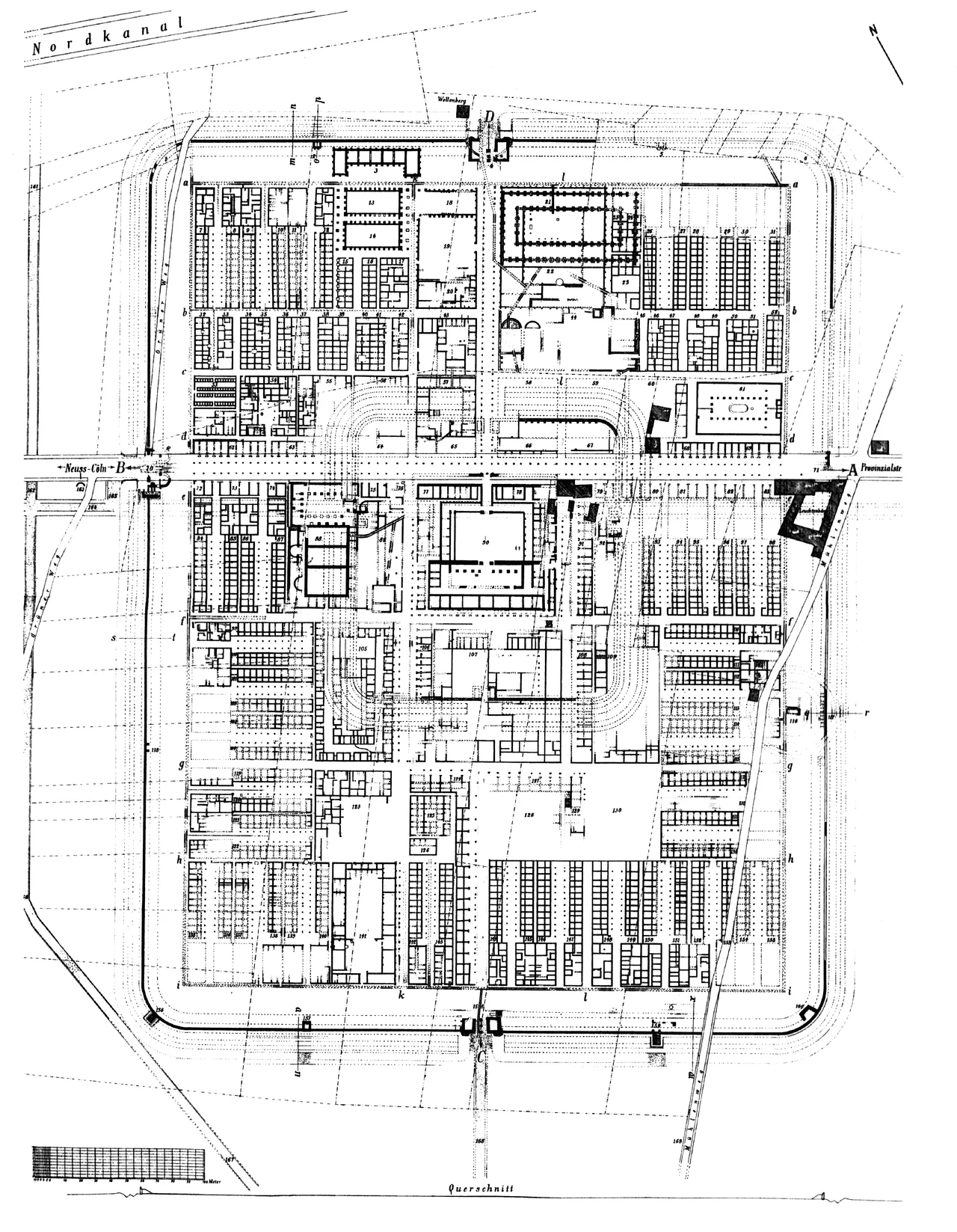
Constantin Koenen was twenty-three years old when he started arguing with the older archaeologists. They were certain the lost Roman legionary fortress lay under the old town center of Neuss. Koenen, an amateur with no academic post, thought it was somewhere else - to the south, on open ground out by the confluence of the Erft with the Rhine. In 1886 he talked the Bonn Provincial Museum into letting him dig a test pit. The pit hit something. Over the next thirteen years Koenen and his team moved roughly fifty thousand cubic meters of soil, by shovel and wheelbarrow, and revealed the first complete ground plan of a Roman legionary fortress ever known anywhere in the world.
The Playing Card
What emerged from the dirt was a perfect rectangle with rounded corners - the shape archaeologists still call a Roman "playing card" fortress. Twenty-five hectares. A substantial stone gate on each of the four sides. Turrets at regular intervals along the walls. Inside, the foundations of sixty-two infantry barrack blocks arranged around a central administrative core: a colonnaded headquarters, the governor's residence, officers' houses, cavalry barracks, workshops, granaries, a bath-house, an infirmary. Everything a legion of about five thousand soldiers needed to live, train, fight, and recover. When Koenen published the full results in 1904, the volume was a sensation across European archaeology. For the first time, a Roman legionary fortress was not just a textual reference. It was a measurable, mapped reality. The plan became the template for understanding every other castra excavated since.
Sixteen BCE to the Year of Four Emperors
The fortress Koenen mapped was not the first Roman presence at Novaesium. Augustus had pushed the legions to the Rhine around 16 BCE, and for the next sixty years a succession of temporary earth-and-timber camps occupied the marshy ground along the river - tents for the legionaries, wooden palisades that rotted and were rebuilt. The big stone fortress went up around AD 43, when the emperor Claudius decided the Rhine would be the permanent border of the empire and that the legions guarding it deserved permanent quarters. Tacitus names Novaesium in ten different passages of the Histories, mostly during the chaos of 69 CE, the Year of the Four Emperors. The Legio XVI Gallica based at Novaesium marched on Rome in support of Vitellius, returned, failed to contain the Batavian Revolt the following year, and was disbanded. The Legio VI Victrix replaced them and stayed until the end of the first century, when the fortress was abandoned and the legion shifted north to Xanten.
Camp H and the Long Decline
After the legion left around AD 100, Novaesium was not erased - it shrank. The central area of the old fortress was rebuilt as a smaller auxiliary camp known to archaeologists as Camp H, about three hectares, with walls 1.8 meters thick and ditches up to twenty-one meters wide. The garrison appears to have been a cavalry unit - a gravestone of a rider from the ala Afrorum veterana, dated around AD 100, hints at one possibility. Camp H stood for nearly two centuries before Frankish raiders sacked it in 256, and again in 275 during the collapse of the breakaway Gallic Empire. Even then, the site refused to die. Fourth-century finds suggest some form of Roman presence continued for another fifty years. Around 388, the chronicler Sulpicius Alexander (preserved in Gregory of Tours) records a Roman general named Quintinus crossing the Rhine near Neuss, finding empty villages, and getting his legions cut to pieces in the woods by Frankish ambushers. The classical world ended in places like this, one disaster at a time.
Buried Under Bungalows
Here is the tragedy of Novaesium for modern archaeology: the city of Neuss built houses on top of it. Through the 1950s and into the 1980s, as the Gnadental district expanded south, rescue excavations raced ahead of construction crews, snatching what they could before the foundations were poured. The Rhineland State Museum led most of the work; from 1957, the German Research Foundation funded it. Significant findings came out of the ground - amphorae from the earliest occupation, the layouts of camps that had been only guessed at before. But most of the 25-hectare fortress now lies under suburban Neuss, accessible only when a sewer line breaks or a building permit allows a small dig. The chronology of the multiple overlapping camps remains, even in 2024, unresolved.
World Heritage, At Last
In 2021, UNESCO inscribed the Frontiers of the Roman Empire - Lower Germanic Limes as a World Heritage site, a string of 102 locations from south of Bonn to the Dutch North Sea coast. Novaesium is one of them. In 2022, the University of Bonn launched an 18-year research program on the four great legionary bases of the Lower Rhine - Bonn, Neuss, Xanten, and Nijmegen - finally bringing modern methods to bear on what Koenen began with a shovel. Many of the original finds live at the Clemens Sels Museum in Neuss. The site itself? Houses, gardens, a police training center built on the parade ground. You walk past it without knowing. The legion is gone. The ground remembers.
From the Air
Located at approximately 51.184 N, 6.722 E in the Gnadental district of southern Neuss, near the confluence of the Erft with the Rhine. The 25-hectare fortress footprint is now suburban housing - look for the dense modern neighborhood pattern between the Rhine and the Erftmouth. Nearest airport: Dusseldorf International (EDDL), 18 km northeast. From altitude, the broad U-shape of the Erft entering the Rhine just south of Neuss city center marks the general area where the legion was once garrisoned.
Nearby Stories
- Lindenstraße 0.4 km away
- German Football Museum 5.4 km away
- Diamond Interchange: How a Simple Idea Reshapes Towns Like Julich 7 km away
- Gladbeck 12 km away
- Hagen Open-air Museum 12 km away
- Homburg Castle 13 km away
- RAF Bruggen 15 km away
- Weeze 16 km away