Weeze
The day the British left Weeze, almost half the town's economy walked out with them. RAF Laarbruch had operated on the edge of this small Lower Rhine municipality since 1954, and when the base closed in 1999, 400 jobs disappeared overnight and roughly 5,000 base personnel and their families packed up for England. For a town of 10,500, this was an existential blow. The mayor's office faced a runway, a fuel depot, a control tower, miles of taxiways, and no obvious plan for what to do with any of it. The answer they landed on, after a few years of arguing about it, was deceptively simple: keep the runway, sell the empty seats. Today Airport Weeze handles roughly two million passengers a year, most of them Dutch and German tourists chasing cheap fares on Ryanair, and the town's population has crept back above where it was when the British still flew.
A Document From 855
Weeze first appears in a document from King Lothar II in the year 855, when the Carolingian monarch granted Count Ansfried an estate east of the River Niers. The name Weeze itself was not officially recorded until 1226, when Earl Henry III of Alpen gave the Cistercian monastery at Kamp some farmland in the area. People had lived here for considerably longer. Stone Age and Bronze Age artifacts have been found across the municipality, including a burial ground in the Kalbeck area that once contained around a thousand tumuli. A Roman road from Cologne to Nijmegen ran through what is now Weeze, and a hoard of Roman silver coins came out of the soil. The Franks left burials in the town center from around the 8th century. Weeze has been a small but persistent presence on this stretch of the Niers for at least 1,200 years.
Three Castles in a Cycling Distance
The Niers winds through Weeze past three castles worth a slow cycling day. Wissen Castle, south of town on the B9, is a moated complex whose roots reach back to the 14th century, though most of what stands today is neo-Gothic from the von Loe family's extensive rebuilding between 1969 and 1973. Its neo-Gothic chapel from 1876 is the work of Cologne architect Vincenz Statz. North of town, hidden in dense woodland, is Kalbeck Castle, first documented as a moated stronghold in 1326 and burned down enough times that Baron Friedrich von Vittinghoff-Schell rebuilt it in 1909 in the style of 18th-century Westphalian water castles. The gardens host classical concerts in summer. East of Weeze stand the ruins of Hertefeld Castle, a 14th-century manor that grew into a Baroque palace and was almost entirely destroyed in 1945. The surviving walls have been stabilized so that they can host outdoor theater. The estate is still owned by the Eulenburg-Hertefeld family.
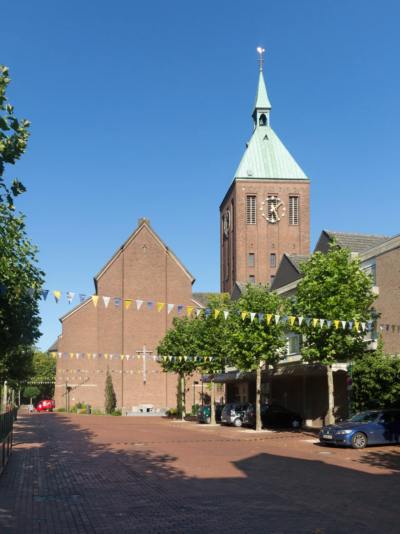
The Saint Who Bound a Dragon
Weeze's coat of arms, granted by the Prussian Ministry of State on 28 April 1928, tells most of the town's story in a single image. On the left half stands Saint Cyriacus, the town's patron saint, holding a book and a palm. On the upper right is a black dragon's head against a golden field, a reference to the legend that Cyriacus enchained a dragon. The lower right shows five red roses on a green twig, the Geldrian roses that mark the town's old affiliation with the Duchy of Geldern. The Catholic Church of St. Cyriakus, restored after wartime damage, still anchors the town center. The 1945 destruction was almost total: roughly 80 percent of Weeze was flattened during the final months of the war. The rebuild took the 1950s and 1960s and produced the modest town square that now hosts the annual Kirmes carnival fair, Christmas markets, and street parties.
From RAF Hangars to Ryanair Gates
RAF Laarbruch was a Cold War workhorse, base for British Tornadoes and Harriers covering the Inner German Border. When NATO decommissioned the base in 1999, Weeze had to invent itself again. Airport Weeze, also known as Niederrhein, began commercial operations in May 2003 in a terminal converted from a 1933 steel building. Low-cost airlines moved in fast. About 11 million travelers a year now pass through, the majority Dutch coming for cheap flights to the Mediterranean and back. The airport employs around 350 locals, and the municipal council in 2014 was targeting a future population of 12,000, up from 10,500. The early years were not smooth. On 3 January 2006, a German administrative court suspended the airport's operating license over noise complaints, though flights continued while the case wound through the courts. The town that rebuilt itself after 80 percent destruction in 1945, and then after losing 40 percent of its population in 1999, has now done it twice.
Bridle Paths, Old Oaks, and a Children's Zoo
For everyone who doesn't arrive by jet, Weeze is a quiet Niers-valley town surrounded by woodland and protected nature. The Herrensitz cycling route loops past castles and across the Dutch border to Gennep, where the Niers meets the Meuse. The Weeze animal park, next to the Hertefeld ruins, draws families with an educational trail and a children's zoo. Protected natural sites include trees with names of their own: the Kroneiche in Vorselaer, an oak with a trunk circumference measured in meters; the Truppeiche and the Zigeunereiche near the Protestant cemetery; two enormous chestnuts at Heishof in Kalbeck; and twenty pollarded oaks at Bussenhof. About 72 percent of Weezenaars identify as Roman Catholic, 17 percent Protestant. They speak German and, with so many Dutch neighbors and visitors, a fair amount of Dutch as well. The town is twinned with Watton in Norfolk, England, a quiet acknowledgment of the British years that everyone here remembers.
From the Air
Weeze lies at 51.63 degrees north, 6.20 degrees east, in the German Lower Rhine region close to the Dutch border. The town sits on the River Niers between Goch to the north and Kevelaer to the south. Weeze Airport (EDLV) is the dominant local landmark from altitude, on the site of former RAF Laarbruch with a single 2,440 m runway running roughly southwest to northeast. The Dutch border lies just a few km west, and the Reichswald forest stretches to the southwest. Other nearby airports include Niederrhein controlled airspace, Dusseldorf (EDDL) 70 km southeast, and Eindhoven (EHEH) 60 km west across the border.
Nearby Stories
- Battle of Tolhuis 2.5 km away
- Kaiserpfalz Kaiserswerth 4.8 km away
- Assault on Nijmegen 7.5 km away
- Wire of Death 8.5 km away
- Sint-Oedenrode 12 km away
- Winterswijk 13 km away
- Landschaftspark Duisburg-Nord 14 km away
- RAF Bruggen 14 km away