,_7-Eleven_stores_in_Taiwan_Shops_in_Donghe,_Taiwan.JPG)
Eastern Taiwan
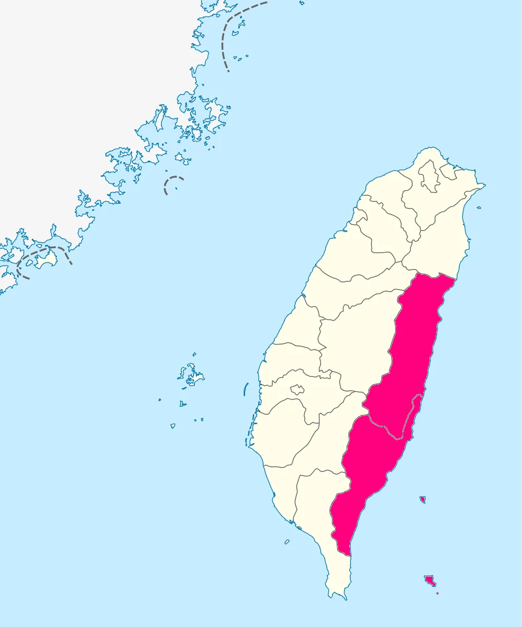
The mountain range doesn't taper gently toward the coast on this side of Taiwan. It ends. The Central Mountain Range, which runs the length of the island's spine, meets the Pacific in a series of cliffs and headlands that drop hundreds of metres to the water—or, in the sections where rivers have carved valleys through, opens into lush corridors of farmland flanked by ridgelines on both sides. This is Eastern Taiwan: the three counties of Yilan, Hualien, and Taitung, strung north to south along a coast that faces the open Pacific and turns its back on the populated west. It is a part of the island that resists the casual visit. Getting here requires crossing the mountains—or going around them—and leaving feels the same way. That difficulty has preserved something. The east coast is where you find the most significant indigenous communities in Taiwan, the most dramatic scenery, and a pace of life that the west side largely exchanged for density and development decades ago.
Three Counties, One Coast
Eastern Taiwan divides into three administrative units arranged from north to south. Yilan County occupies the northeastern corner of the island, a roughly triangular basin drained by the Lanyang River, backed by mountains and open to the sea. Its coastal views rank among the finest in the region, and townships like Toucheng have built reputations as surf destinations and art communities, with old sugar factory buildings repurposed into creative spaces and cafes. Yilan's largest aboriginal population lives in the county's more mountainous areas, and hiking trails thread through terrain that few visitors reach. Hualien County is the largest county in Taiwan by area and the one most visitors associate with the east coast experience—home to Taroko Gorge, the East Rift Valley, and Hualien City, which serves as the regional hub and the base for anyone exploring the surrounding landscape. Taitung County forms the southern third, broader and more varied, with the Rift Valley continuing south and a coastline that draws surfers to Chenggong and whale watchers to the waters offshore.
Indigenous Taiwan
The east coast is home to a disproportionate concentration of Taiwan's sixteen officially recognized indigenous peoples. Hualien County's East Rift Valley is one of the core homelands of the Amis, the largest indigenous group in Taiwan, while the Bunun maintain villages in the mountain townships of both Hualien and Taitung. Taitung City itself has a population that is strongly Aboriginal, Hoklo, and Hakka—an ethnic and cultural mix that gives the city a character distinct from anywhere on the west coast. The presence of indigenous communities here is not residual or nostalgic. It is everyday: in the languages spoken in markets, in the architecture of community centers and ceremonial grounds, in the harvest festivals that mark the Amis agricultural year, and in the music that emerges from these communities—particularly the Bunun's remarkable polyphonic choral singing, known internationally and still practiced in villages throughout the mountains. Writing about eastern Taiwan without centering this indigenous presence would be a fundamental misreading of the region.
Getting In, Getting Through
Eastern Taiwan's relative isolation is a function of topography. The Central Mountain Range creates a substantial barrier between east and west, and crossing it has historically required either tunnels, passes, or long detours around the northern or southern tips of the island. The most convenient public-transport connections are through Yilan County in the north—where the Hsuehshan Tunnel links Taipei to Yilan in under an hour by road—and through the southern crossing by railway into Pingtung County. Between those two endpoints, the east coast stretches some 370 kilometres, with the Hualien–Taitung railway connecting the main towns along the corridor. By car, the experience is more flexible but not always faster—the roads wind, and the landscape demands attention. The length of the coast and the scarcity of east–west crossings means that most visitors who arrive plan to stay for more than a day. The region does not yield its character on a brief pass-through.
Hualien and the Northern Edge
Hualien City anchors the northern part of the region's prime destinations. As the county seat and the largest urban centre on the east coast, it is where flights land, where buses and trains connect, and where visitors base themselves before heading south into the Rift Valley or north into Taroko Gorge. The gorge—carved by the Liwu River through a marble and schist canyon—is among the most visited natural landmarks in Taiwan, and the highway that threads through it remains one of the more dramatic stretches of road in Asia. Hualien itself is a city with a creative community, a food culture that draws on the region's agriculture and indigenous traditions, and a beachfront that looks out at the Pacific across a dark-sand shoreline. The city was severely affected by the April 2024 earthquake that struck the region—a reminder that eastern Taiwan sits on one of the most seismically active tectonic boundaries on Earth.
Taitung and the Southern Pace
Taitung City occupies the southern end of the east coast experience. It is, by the assessment of many who have spent time there, one of Taiwan's most pleasant cities—not for monuments or museums but for atmosphere. The city was developed during the Japanese colonial period as a base for Pacific expansion, and that history left an infrastructure of civic buildings and planned streets that the postwar decades did not entirely erase. Today Taitung is relaxed in a way that cities on the west coast are generally not, with a strong indigenous, Hoklo, and Hakka mix in its population and a cultural calendar that includes events rooted in each of those traditions. Offshore, Green Island and Orchid Island are accessible by ferry or small plane, each with its own distinct character. Chenggong to the north is the surfing and whale-watching hub. The coast between Taitung and Hualien, served by the Huatung Coastal Highway, is alternately dramatic and serene—sea cliffs giving way to fishing villages, the Pacific always somewhere to the east.
From the Air
Eastern Taiwan's center point is approximately 23.64°N, 121.39°E, with the region extending from Yilan in the north (roughly 24.7°N) to Taitung in the south (roughly 22.7°N). From altitude, the east coast is defined by the abrupt eastern face of the Central Mountain Range and the narrow coastal plain or rift valley that separates the mountains from the Pacific. Hualien Airport (RCYU) at approximately 24.02°N, 121.62°E is the primary gateway; Taitung Airport (RCFN) at approximately 22.75°N, 121.10°E serves the southern section. Flying south along the east coast at 5,000–8,000 feet on a clear day reveals the full geographic logic of the region: mountains on the right, ocean on the left, the East Rift Valley corridor visible as a distinct agricultural strip between the Central Range and the lower Coastal Range. The Hualien River, Xiuguluan River, and Beinan River appear as silver lines cutting east through the Coastal Range to the Pacific. Watch for afternoon convective activity building over the Central Range in summer; the east coast itself is often clear when the west coast is overcast.
Nearby Stories
- Paper Dome 4 km away
- Liyu Lake 5.2 km away
- Hai'an Range 11 km away
- Xitou Nature Education Area 15 km away
- Namasia District 25 km away
- Twin Forts of Romblon 1201 km away
- Sinking of MV Sewol 1209 km away
- Sibuyan Island 1250 km away