Eilendorf (Aachen)
The name used to be Erlendorf, meaning village of the alders, because alders need wet ground and the soil here held water. Then Aachen mouths got hold of it. The local dialect rounded the consonants, slurred the syllables, smoothed out the consonant cluster that had named the place - and Erlendorf gradually became Eilendorf. The town's actual trees, the alders that gave it the name, are mostly gone. The wetness is mostly drained. But the linguistic fossil persists, repeated by 15,000 inhabitants who live in an Aachen borough that still keeps two crossed mining hammers on its coat of arms.
Smithsonite and the Cornelius Horn
Eilendorf grew up around a smithsonite mine - smithsonite being a zinc carbonate ore that the medieval Rhineland prized for making brass. There was a dolomite quarry as well, and a needle manufactory. None of these survive in operation. But the coat of arms, divided vertically, keeps the memory alive: on the left, two mining hammers crossed on a blue field, and a stylized viola flower; on the right, the Cornelius horn on a red field, inherited from the nearby Kornelimünster Abbey, whose Abbot Florenz made the first recorded gift mentioning Eilendorf in 1238. The town existed long before that document. It just had not yet been written down.
The Foreign Armies Came Through
Sitting on the road between Aachen and Cologne, Eilendorf collected centuries of trouble that had nothing to do with anyone living there. From 1577 to 1583 foreign troops involved in the Cologne War billeted themselves on local farms, taking what they wanted. From 1630 to 1640 the Thirty Years' War rolled through. In 1678 the armies of Louis XIV of France arrived on what the chroniclers called a war of conquest. The French Revolution finally dissolved the Kornelimünster Abbey itself in 1794, and by 1802 all church properties had become state property. The little farming village survived all of it. By 1797 it was bundled politically with Forst, Weiern, and Hoefen; on 1 April 1886 it broke off to elect its own mayor; on 27 April 1900 it merged with Nirm to form a single community; on 1 January 1972 it disappeared into Aachen as one of seven boroughs.
View from the Wolfsberg
The highest ground in Eilendorf is a hill called the Wolfsberg, or Gottes Segen - God Bless. It rises to 230 meters above sea level, which sounds modest until you stand on it and look. From the top, the whole basin of Aachen unfolds: the cathedral spire to the west, the Lousberg shouldering up behind it, the dense green wall of the Aachen Forest beyond that. On clear days the line of the Eifel mountains appears to the south, blue and low against the horizon. In winter the slopes turn into a sledding hill. In summer people lie on the grass with their shirts off. Through the lower ground toward the Eifel, the villages of Nirm and Oberdorf sit on slopes fifty meters apart in elevation - small terrain, but enough to give Eilendorf its own weather and its own light.
Two Churches, One Parish
St. Severin Church traces back to the founding of Kornelimünster Abbey. Abbot Hyazinth Alfons - Count von Suys, who held the office from 1713 to 1745 - laid the foundation stone for a new place of worship on the site of an earlier, probably Romanesque church. The Cologne master builder Heinrich Wiethase designed the present three-nave structure in 1864, and a tall bell tower went up between 1904 and 1908. The foundation stone Abbot Hyazinth had laid is still visible inside the tower. St. Apollonia, on Heck Street up in the upper village, is much newer - designed by the Aachen architect Peter Salm and built between 1959 and 1961, with a mechanical Weimbs organ added in 1988. For most of the 20th century the two churches ran separate parishes. On 1 January 2010 they merged, joined by St. Barbara in nearby Rothe Erde, into a single parish administered as St. Severin of Eilendorf and Rothe Erde.
Pannhaus, Pranger, and the Slow Erasure
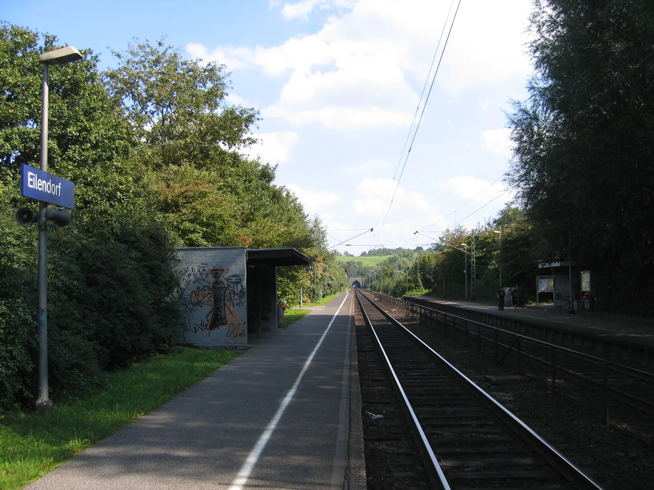
The oldest surviving structure in Eilendorf is the Pannhaus Brewery, a building once associated with the abbey. A cornerstone added at some later date used to serve as the village pranger - the pillory where wrongdoers were put on public display. Half a century ago there were still farms and open fields between Aachen and Eilendorf. Now the industrial zones of Rothe Erde and Eilendorf South have grown into one another, and the seam is invisible. The Haarbach stream still runs northeast under the train lines toward Eschweiler, the Eilendorf platform still puts commuters in Aachen-Hauptbahnhof in seven minutes, and the green space that remains is mostly given over to cattle and hay rather than to crops. The mining hammers on the coat of arms refer to an industry that closed a long time ago. The viola in the same blazon refers, just as faithfully, to a flower.
From the Air
Coordinates: 50.7796°N, 6.1534°E. Eilendorf sits about 6 km east of central Aachen, on the rail line toward Stolberg and Cologne. The Wolfsberg hill at 230 m offers a clear visual reference - it is the high point on the eastern edge of the Aachen basin. The borough blends into Aachen-Mitte to the west and into Stolberg's Atsch district to the east. Recommended viewing altitude: 2,500-4,000 ft AGL, particularly approaching from the north over the Wurm valley. Nearest airports: Maastricht Aachen (EHBK) 40 km NW; Cologne-Bonn (EDDK) 65 km E.
Nearby Stories
- Heinsberg-Lindern Railway 7.8 km away
- Baptismal font at St Bartholomew's Church, Liège 7.8 km away
- Federal Office for the Protection of the Constitution 16 km away
- Limburg (Belgium) 17 km away
- F.L.Y. 17 km away
- Marcinelle Mining Disaster 84 km away
- Fort Jeanne d'Arc 148 km away
- Marmoutier Abbey 202 km away