El Nido, Palawan
The name comes from the nests. High on the marble and limestone cliffs that rise sheer from Bacuit Bay, swiftlets build their edible nests in crevices that no casual climber can reach. Spanish colonizers called the place El Nido -- "The Nest" -- and for centuries, the gathering of those nests was one of the few reasons outsiders came here at all. Now the reasons are everywhere: lagoons walled by karst towers, coral reefs dense with hundreds of fish species, and beaches that Conde Nast Traveler has placed among the twenty most beautiful in the world. What was once a remote fishing town at the far end of a difficult road has become the Philippines' most celebrated island destination.
Cliffs, Currents, and First Peoples
El Nido occupies the northern tip of Palawan, where limestone karst formations jut from turquoise water like the ruins of some drowned cathedral. The original settlers were the Tagbanwa and Cuyunon peoples, whose presence predates any written record. Over the centuries, Tagalogs, Hiligaynon, Bicolanos, Ilocanos, Chinese, and Spanish all arrived, creating the cultural mosaic that defines the town today. Intermarriage between these groups is common, and the linguistic landscape reflects the blending -- Filipino is the main language, but English, Hiligaynon, Visayan languages, Bicolano, and the indigenous Cuyonon are all spoken. The municipality was carved from Taytay in 1916 during the American colonial period, giving El Nido its own governance over eighteen barangays, eighty-five percent of whose residents still live in rural areas.
The Nest Gatherers and the New Economy
Before tourism transformed El Nido, the local economy ran on coconut, rice, cashew, banana, mango, and fish. Edible bird's nest gathering -- the activity that gave the town its name -- remains an economic pursuit, though it is seasonal and increasingly overshadowed by the visitor economy. CNNgo has called El Nido the best beach and island destination in the Philippines, citing its "extraordinary natural splendor and ecosystem." That recognition has brought rapid growth: the 2007 census recorded 30,249 residents across 6,311 households, with an annual growth rate of 3.58 percent -- well above the national average. The tension between development and preservation is the town's defining challenge, and the reason its protected area status matters so much.
Nine Hundred Square Kilometers of Sanctuary
In 1984, the Philippine government designated a 360-square-kilometer area around El Nido as a turtle sanctuary. By 1991, Bacuit Bay and its islands had been proclaimed a marine reserve. The protections kept expanding -- in 1992, the Department of Environment and Natural Resources extended coverage further, and in 1998, the entire terrestrial and marine ecosystem of El Nido and portions of neighboring Taytay were declared a protected area. The resulting El Nido-Taytay Managed Resource Protected Area spans 903.21 square kilometers, making it the largest marine sanctuary in the Philippines. Within those boundaries live an estimated 813 species of fish and 45 genera of hard coral. The provincial government has organized citizen patrols -- "Bantay Gubat" for forest protection and "Bantay Dagat" for marine preservation -- turning conservation from a government mandate into a community practice.
Getting to the Edge of the Map
El Nido's remoteness was once its primary characteristic. Lio Airport, the town's sole airfield, handles small aircraft connecting to other Philippine destinations. By road, daily buses and jeepneys make the long run from Puerto Princesa, Palawan's capital, along a highway that passes through Taytay on a rehabilitated 60-kilometer stretch that has done more than almost anything else to boost tourism in the area. By sea, ferries from Manila serve the main port at Buena Suerte, while smaller wharves in rural barangays handle local traffic. Tricycles shuttle visitors around the town proper. The infrastructure is growing, but El Nido remains a place that rewards the effort of getting there -- a destination that feels earned, where the limestone towers rise from water so clear it seems almost fictional.
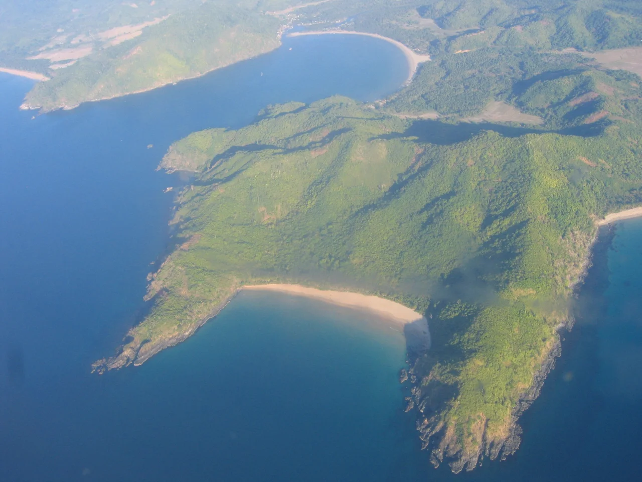
From the Air
El Nido sits at approximately 11.18N, 119.39E on the northern tip of Palawan island. From the air, the dramatic limestone karst formations of Bacuit Bay are unmistakable -- towering rock pillars rising from turquoise lagoons. El Nido Airport/Lio Airport (RPME) is the closest airfield, handling small turboprop traffic. Puerto Princesa Airport (RPVP) lies approximately 230 km to the south. Best viewing altitude is 2,000-5,000 ft to appreciate the contrast between the karst cliffs and the lagoons. The coastline faces the South China Sea to the west.
Nearby Stories
- Fort Santa Isabel 19 km away
- Coron, Palawan 73 km away
- Calauit Safari Park 113 km away
- Fort Cuyo 123 km away
- Cuyo, Palawan 129 km away
- Puerto Princesa 129 km away
- Iwahig Prison and Penal Farm 159 km away
- 2019 Reed Bank Incident 218 km away