Ennedi Est (province)
Amdjarass has a population of just over 20,000 by the 2009 census, yet its airport has the longest runway in Chad - 3,050 meters of hardened asphalt in the middle of the Sahara. In December 2024, Reuters reported that dozens of UAE flights had been landing there, and a United Nations panel accused the Emirates of using the strip to funnel weapons to the Rapid Support Forces fighting across the border in Sudan. The UAE denied it, calling the cargo humanitarian aid. Fifty kilometers away, the Ouré Cassoni refugee camp held 67,682 people as of May 2025 - almost all women and children of the Zaghawa ethnicity, fleeing the war that airport may be supplying.
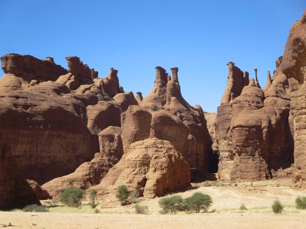
An Arch in the Desert
The geography of Ennedi Est is spectacular and mostly unvisited. The province occupies Chad's far northeastern corner, bordering Libya's Kufra District to the north, Sudan's North Darfur to the east. Most of it is Sahara: the Erdi Plateau and the Mourdi Depression in the north, the eastern reaches of the Ennedi Plateau in the center. The Ennedi, a UNESCO World Heritage Site, is a sandstone bulwark riddled with towers, bridges, and arches. Julia Arch rises here, its span of stone improbably suspended over a sea of dunes. At the guelta of Bachikélé - one of those rare pools where water survives the dry season - grows Rauvolfia afra, a tropical tree that should not exist this far north. It is a living fossil from a wetter age, rooted at a desert spring.
Lines Drawn on Sand
The northern strip of Ennedi Est lies within the Aouzou Strip, a band of desert that Libya and Chad fought over for decades before the International Court of Justice awarded it to Chad in 1994. The province itself was only established in its current form on September 4, 2012, when Chad divided the old Ennedi Region in two. Before that it had been Ennedi Est Department within successive parent units, going back to the Borkou-Ennedi-Tibesti Prefecture of the colonial era. The succession of boundaries and parent units reads like a geology of administration, sedimenting and shifting, while the people on the ground - Dazaga, Toubou, and Zaghawa - have lived across these lines for much longer than any of them have existed.
The Camp at Kariari
Near Kariari Dam, with its storage capacity of 12 million cubic meters, sits the Ouré Cassoni refugee camp. The UNHCR's May 2025 figures counted 67,682 people in 16,797 households - a population triple that of the province's capital. Over 99 percent are Zaghawa; 92 percent are women and children. They came across the border from Sudan's Darfur, where the war between the Sudanese army and the Rapid Support Forces has displaced millions and killed an estimated hundreds of thousands. The United Arab Emirates is building a water treatment plant at Kariari to supply Amdjarass and its surroundings. The airport's 3,050-meter runway, named for Chad's late president Idriss Déby Itno, can accept the largest cargo jets. In the desert, humanitarian and strategic interests converge at the same asphalt.
A Semi-Arid Year
The climate here is brutal and variable. January mornings can drop to 6°C. May afternoons climb past 41°C. Summer is warm and stable around 31°C; winter is cool around 10°C. Somewhere between January's chill and May's heat, the window for travel opens and closes. The province's landscape is ancient - monsoons carve and repair it, sandstone arches catch the wind, and much of the Sahara's blowing sand originates in the Tibesti-Ennedi triangle upwind, from the slow erosion of this same rock. From the air, Ennedi Est reads as a mosaic of yellow and pink sandstones, black basalt inselbergs, wadis that run briefly in rare rains and dry again within hours. A single paved road, the long runway at Amdjarass, and the scattered white tents of the camp are the only obvious signs of the twenty-first century.
From the Air
Coordinates 17.65°N, 23.15°E, in far northeastern Chad. Amdjarass International Airport (FTTE, formerly Am-Djarass) has a 3,050-meter runway. Recommended viewing altitude 15,000-25,000 feet to see the Ennedi Plateau's sandstone formations and the sweep of Sahara toward the Libyan and Sudanese borders.
Nearby Stories
- Ennedi Plateau 45 km away
- North Darfur 206 km away
- Nubian Sandstone Aquifer System 276 km away
- Al Zorg 291 km away
- Lake Ptolemy 359 km away
- Zakouma National Park 791 km away
- Great Man-Made River 842 km away
- Manovo-Gounda St. Floris National Park 1025 km away