Nubian Sandstone Aquifer System
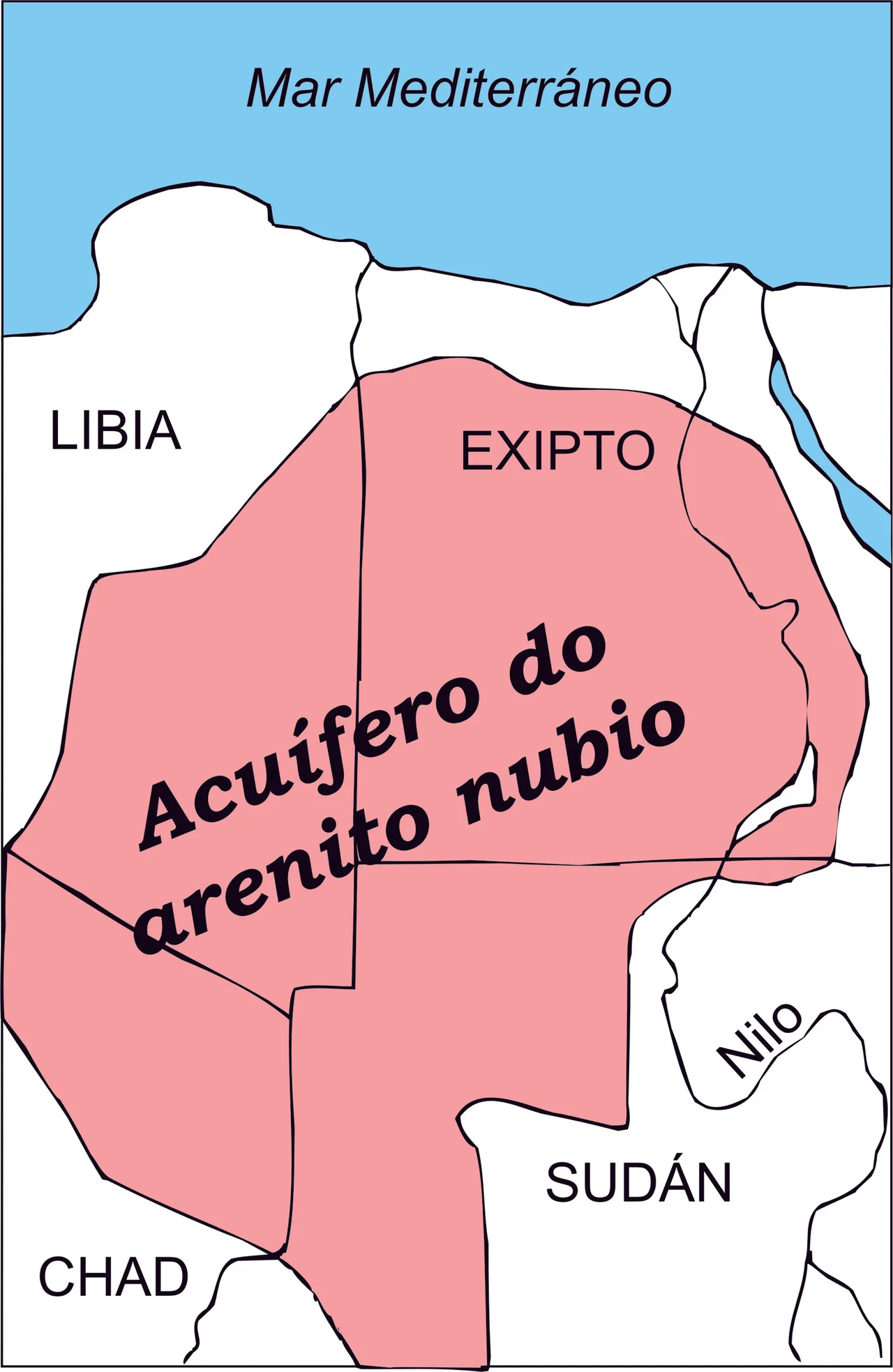
Beneath one of the driest places on Earth sits enough water to cover all of France in a pool more than 280 meters deep. The Nubian Sandstone Aquifer System holds an estimated 150,000 cubic kilometers of groundwater -- more fresh water than most of the world's surface lakes combined. It is buried beneath roughly two million square kilometers of the eastern Sahara, underlying most of Egypt, southeastern Libya, northeastern Chad, and northwestern Sudan. The water was not deposited there by anything still happening today. Some of it arrived as rainfall 38,000 years ago, when the Mediterranean climate reached deeper south than it does now. Other portions date back 361,000 years and trace to storms blown in from the tropical Atlantic. The rain has long since stopped. The water remains.
A Water Bank Without a Rain
A fossil aquifer is exactly what it sounds like -- water banked underground from climatic eras that no longer exist. The Nubian Sandstone Aquifer's two recharge events were separated by hundreds of thousands of years, and together they produced one of the planet's singular groundwater reservoirs. Rain falling today in the Sahara barely contributes. Some minimal recharge still occurs from the few wet zones along the aquifer's southern margin, but the vast majority of what sits underground was put there during ancient wet periods and has been slowly migrating through the sandstone ever since. This makes every liter withdrawn from the NSAS effectively non-renewable on any human timescale -- when it is gone, it is gone.
The Geology Beneath the Dunes
The aquifer sits within Nubian Sandstone, a formation of hard ferruginous sandstone interleaved with shale and clay, 140 to 230 meters thick. The water stored in its pores ranges from fresh to slightly brackish, with salinity between 240 and 1,300 parts per million. Sodium dominates the cations over calcium and magnesium; chloride dominates the anions over sulfate and bicarbonate. The chemistry reflects the long residence time -- water that has sat in contact with gypsum-rich shales for tens of thousands of years picks up its chemical signature from that contact. The sandstone's ferruginous composition gives the stone its characteristic rust-red color where it outcrops; drive across certain stretches of southern Egypt or northwestern Sudan and you are crossing the exposed upper layers of a reservoir system that extends kilometer-deep beneath you.
Lake Ptolemy's Descendants
Researchers have linked the aquifer directly to Lake Ptolemy, the vast Holocene lake that once covered northern Darfur. Simulations indicate that at Lake Ptolemy's highest stands, the aquifer's water table rose high enough to meet the lake's surface. An estimated 3 cubic kilometers of water per year flowed from the lake down into the aquifer during its existence -- a slow recharge that continued for thousands of years as the lake drew on Holocene monsoons. When the monsoon retreated and the lake dried, that transfer ended. The aquifer had already absorbed what it could. Some portion of what the desert now holds in its hidden pools was, ten thousand years ago, surface water with hippos wading in its reeds.
The Great Man-Made River
In the 1980s, Libya's Muammar Gaddafi launched what he called the Great Man-Made River -- an engineering project of almost unimaginable scale that would pump water from the Nubian Sandstone Aquifer in the Libyan desert through a network of underground pipes stretching over 2,800 kilometers to the coastal cities of Tripoli, Benghazi, and Sirte. Construction proceeded in phases through the 1990s and 2000s. The system now extracts approximately 2.4 cubic kilometers of fresh water per year -- more water from a single source than any other irrigation or municipal supply project on Earth. Libyan agriculture and urban life depend on it. But because the water is fossil and non-renewable on human timescales, the project effectively spends a finite inheritance. Calculations of how long the extraction can continue vary from decades to centuries, depending on assumptions. Nobody disputes that there is an end date, only when it arrives.
Four Countries, One Resource
Since 2006, the International Atomic Energy Agency has coordinated the IAEA-UNDP-GEF Nubian Project -- an effort to understand the aquifer's behavior and establish frameworks for its equitable management across the four NSAS countries. Partners include the United Nations Development Programme, the Global Environment Facility, UNESCO, and government representatives from Sudan, Chad, Libya, and Egypt. The project's goal is rational and coordinated management of the resource, protecting biodiversity and land quality while enabling socioeconomic development. In practice, the four countries have interests that do not always align. Egypt has drilled aggressively into the aquifer for the Toshka land reclamation project near Abu Simbel since 2001. Libya runs the Great Man-Made River. Sudan's northwestern reaches remain relatively undeveloped. Chad's extraction is modest. What binds them is a shared reservoir whose fate will be determined not by any one country's restraint but by their collective behavior -- and whose limits are concealed by the fact that the water is invisible until the pump stops producing.
From the Air
The Nubian Sandstone Aquifer System underlies approximately 20 degrees north, 25 degrees east at its geographic center in the eastern Sahara, spanning most of Egypt, southeastern Libya, northwestern Sudan, and northeastern Chad. Best viewed at 30,000 to 40,000 feet across long transects of the eastern Sahara -- the aquifer itself is invisible, but its extraction points are visible at major irrigation projects like Libya's Great Man-Made River terminals and Egypt's Toshka Lakes near Abu Simbel. Nearest major airports to the center: Kufra (HLKF) in Libya, Abu Simbel (HEBL) in Egypt, Dongola (HSDN) in Sudan. Extreme desert conditions, intense heat, and sparse infrastructure define the airspace.
Nearby Stories
- Lake Ptolemy 41 km away
- North Darfur 220 km away
- Ennedi Est (province) 274 km away
- Ennedi Plateau 369 km away
- Cave of Swimmers 376 km away
- Gilf Kebir National Park 394 km away
- Selima Oasis 411 km away
- Great Man-Made River 659 km away