Lake Ptolemy
Picture a sheet of fresh water the size of Lake Erie spread across what is now some of the driest land on Earth. That was Lake Ptolemy, and for roughly seven thousand years it actually existed. Hippopotamuses wallowed in its reed beds. Nile crocodiles slid between its tributary deltas. Giraffes and elephants moved along its southern shore while Neolithic pastoralists herded cattle across grasslands that are now pure Saharan dune. The ancient geographer Ptolemy, writing from Alexandria in the second century, described swamps full of turtles somewhere in this part of Africa -- the chelonide marshes. Nobody could find them. The lake had already started to die.
A Sahara That Was Not a Desert
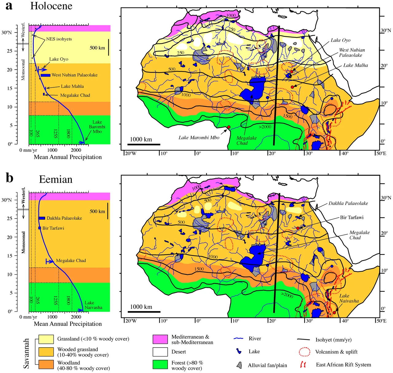
The lake formed because Earth's axis had tilted just enough, and perihelion had slid just far enough into July, to supercharge the African monsoon. Rain that now falls in the tropics once reached deep into what is now Darfur and northern Chad. Runoff from the Ennedi highlands poured north through wadis into a basin carved by older, drier winds. Around 9,180 years ago, radiocarbon dating confirms, a freshwater lake had already taken shape. At its highest stands, Lake Ptolemy may have covered 30,750 square kilometers and reached 83 meters deep -- comparable in size to Great Bear Lake in Canada, larger than Lake Erie. Estimates vary wildly because shorelines are hard to read in a landscape where dunes march over evidence each season, but even the most conservative numbers describe a vast inland sea in a place that today receives essentially no rain.
The Ecosystem Beneath the Sand
Life came in behind the water. Acacia and tamarisk rooted along the banks. Typha reeds fringed the southern margins where tributaries fanned out into wetland deltas. Ten to eighteen species of fish swam the open water, including the Nile perch Lates niloticus, which suggests the lake may once have connected to the Nile drainage itself. Freshwater mussels tell researchers the water was clean near the inflows, though brackish in the evaporative basins. Ostracods, stromatolites, and diatoms left their microscopic architectures in the lakebed. Around the shore roamed cane rats, hartebeest, elephants, and giraffes. Humans noticed all of this. Neolithic pastoralists settled the southern shore, leaving artifacts scattered across the ancient beaches, some of them bearing what researchers believe are religious or spiritual markings.
Slow Drying
Then the monsoon began to retreat. Between about 8,100 and 7,500 years ago, the lake dropped sharply. Land animals walked in where boats would once have floated. The water rose again, fell again, rose once more -- highstands dated to 6,800 years ago show the system still had strength. But the long trend was clear. Wadis that had fed the lake stopped running one by one. By about 3,300 years ago the last tributaries on the southern side were carrying water, and by 2,400 years ago the northern flows had stopped too. The lake split into scattered pools, then into isolated playas, then into nothing but memory and minerals. Today the oases of Oyo, Bidi, and Nukheila sit directly on what was once the deepest water. As the shoreline pulled back, the human settlements followed, chasing water deeper into the basin until there was no basin left.
Water That Did Not Disappear
Lake Ptolemy did not simply evaporate. About three cubic kilometers of its water slipped downward each year into the Nubian Sandstone, the enormous fossil aquifer that stretches beneath Sudan, Egypt, Chad, and Libya. In simulations of the ancient system, the aquifer's water table rose high enough to meet the lake's surface, the two bodies breathing together across porous stone. The lake may have been one of the single largest contributors to an underground reservoir now estimated to hold 150,000 cubic kilometers of fresh water -- the world's largest fossil aquifer system. The sea that vanished from view simply went elsewhere. Libya pulls a fraction of it back up through the Great Man-Made River today, irrigating farms a thousand kilometers from where the rain originally fell.
The Turtle Swamp Remembered
For centuries the lake was known only through Ptolemy's tantalizing reference to marshes no European traveler could locate. A Frenchman's map in 1858 hinted at its existence. Real understanding arrived in 1980 through satellite imagery, which revealed the ghost of the shoreline etched in chalks and yardangs where wind had scoured the old lakebed. Further deposits were recognized in 1985 and 1986. The northeasterly trade winds that once blew across open water now sculpt barchan dunes across its drained southwestern floor. What remains is a landscape that reads like a crime scene of climate change -- tufa pinnacles where tributary deltas used to be, diatomite beds thick enough to shimmer white in the sun, fossilized hippopotamus bones lying on sand. Flying over northern Darfur, you cross an archipelago of dune fields the early mapmakers called the Ptolemy lake archipelago, the highest ground of an ancient lake that no longer has any water to be high above.
From the Air
Located at 19.50 degrees north, 26.00 degrees east in northern Darfur, Sudan. Best viewed at 25,000 to 35,000 feet, where the subtle topographic basin and dune patterns of the former lakebed become visible. Landscape is pure desert -- yardangs, dune fields, and the oases of Oyo, Bidi, and Nukheila marking the deepest ancient water. Nearest airfields are El Fasher (HSFS) roughly 250 km south and Dongola (HSDN) far to the east along the Nile. Clear, stable, extremely arid flying conditions year-round with rare dust storms.
Nearby Stories
- Nubian Sandstone Aquifer System 48 km away
- North Darfur 162 km away
- Ennedi Est (province) 283 km away
- Selima Oasis 359 km away
- Ennedi Plateau 364 km away
- Northern State (Sudan) 365 km away
- Tombos (Nubia) 422 km away
- Cave of Swimmers 439 km away