.jpg)
Erdek
Five kilometers east of Erdek's harbor, in a marshy field off the Bandırma road, the ground holds the buried bones of one of the ancient world's great cities. The columns of its Temple of Hadrian — taller than any others in the Greco-Roman world — were still standing in 1444. Erdek itself, the living town on the western shore of the Kapıdağ Peninsula, has a more modest recent history: a beach resort within a day's drive of Istanbul, a ferry port for the Marmara Islands, a navy base occupying the eastern approach. But the peninsula it anchors has been continuously inhabited and contested for roughly three millennia, and the quiet seafront promenade, the fish restaurants around the harbor, and the summer crowds at the beach northwest of town all sit on a landscape dense with accumulated time.
A Peninsula That Was Once an Island
The Kapıdağ Peninsula juts into the Sea of Marmara from the Anatolian shore, connected to the mainland by the Belkıs Tombolo — a strip of sediment and sand about 1,700 meters wide. Until roughly 2,000 years ago, according to local tradition, the peninsula was an island. Earth tremors lifted the bedrock, the intervening channel silted, and what had been open water gradually became a sandbar, then an isthmus. The ancient city of Cyzicus stood on the peninsula's southern shore, commanding the sea lanes between the Aegean and the Black Sea. Some ancient accounts credit Alexander the Great with building the first road across the newly formed tombolo after his conquest of the region in 334 BC.
Cyzicus was ruined by a series of earthquakes beginning around 443 AD, and its population gradually transferred to nearby Artake over subsequent centuries. The ruins remained — so massive that they were quarried for centuries by Byzantines and Ottomans alike. The city that succeeded it, Erdek, grew up a few kilometers to the west, its harbor offering ferry connections and its beaches attracting summer visitors.
Greeks, Deportations, and Turkish Independence
In the 1880s Erdek was a town of roughly its current size, and its population was predominantly Greek. These were Greek Orthodox communities with roots stretching back through the Byzantine and Ottoman periods to the ancient Greek colonization of the region in the 8th century BC. In 1923, following the Turkish War of Independence and the Convention Concerning the Exchange of Greek and Turkish Populations, the Greek community of Erdek and the Kapıdağ Peninsula was deported — families who had lived in the region for generations, displaced by the population exchange between Greece and the new Turkish republic.
The dilapidated stone walls of a Greek village survive on the road through the mountains to Ballıpınar, an empty reminder of that community's sudden absence. After 1923, Erdek and the peninsula transitioned into a domestic Turkish beach resort — a transformation that gave the town its present character as a seasonal destination for visitors from Istanbul and Bursa.
The Town Today
Erdek's center revolves around its harbor and the ferry port 300 meters to the south. The Gestaş car ferry sails twice daily to Paşalimani Island and makes a circuit of Avşa, Ekinlik, and Marmara Island. Regular services connect to the Marmara Islands, taking about an hour and forty-five minutes, and to Tekirdağ on the far mainland coast in about four hours. The ferry connections make Erdek a node in the Marmara island network rather than simply a coastal town.
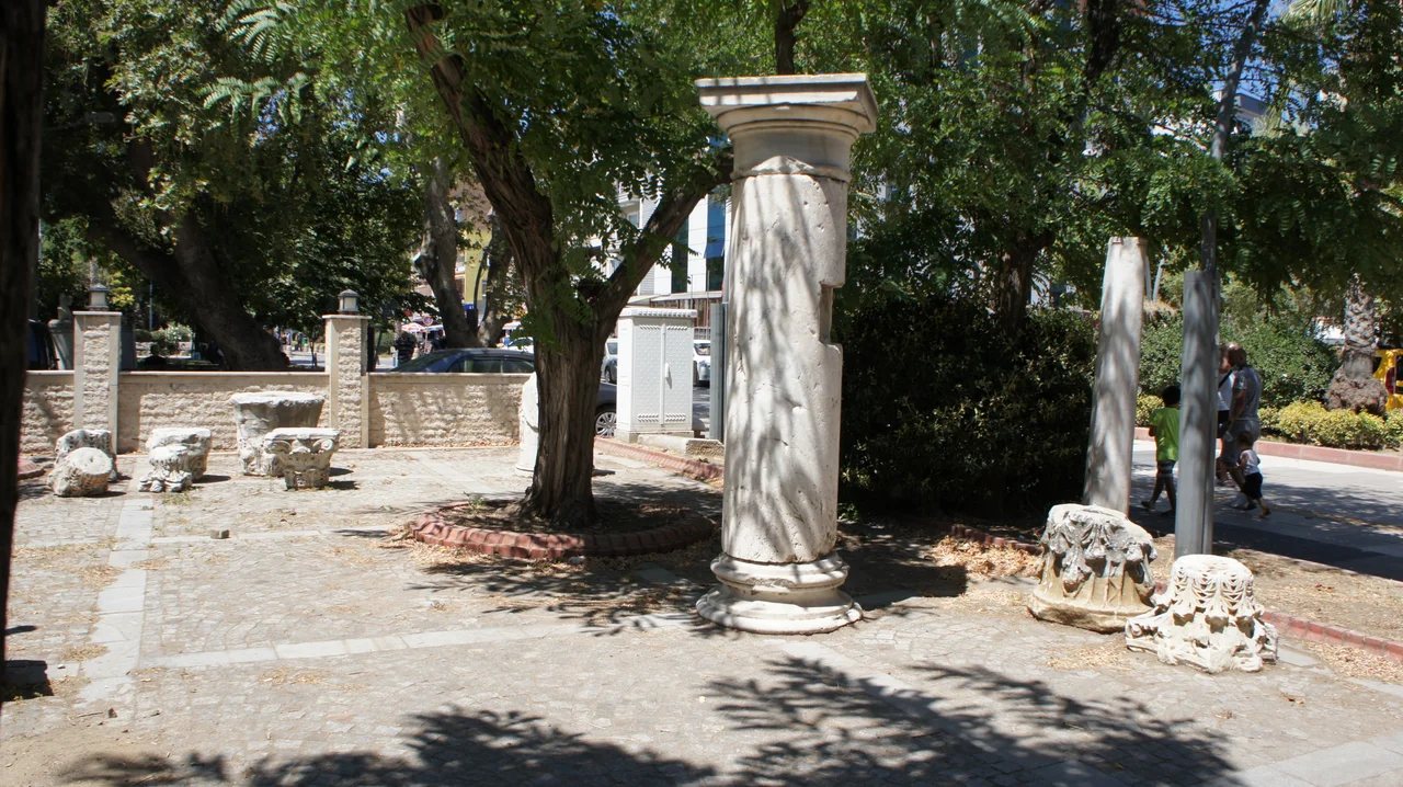
By the harbor, a small open-air museum — free to access around the clock — displays ancient stone monuments from the Cyzicus ruins. The stones have been defaced by graffiti over the years, which gives the place a melancholy quality: relics of one of the ancient world's great cities, sitting in a park by the ferry port, unprotected from passersby. Just offshore, a wooded islet at the harbor's edge holds Byzantine ruins and hot springs; it has variously served as a monastery, a quarantine station, and a spa, and is now also an open-air museum. The main beach stretches northwest of town, with hotels, campsites, and restaurants strung along the shore.
The Ruins at the Edge of Town
The site of ancient Cyzicus lies roughly 5 km east of Erdek, at a place called Bal-Kız, and the distance is significant: it shows how large the ancient city actually was. The amphitheater ruins are at the northern edge of the site, the Temple of Hadrian's foundations to the south — a span that speaks to a city with a substantial footprint. Minibuses running the highway toward Bandırma pass the site, and it is possible to reach it without a car, though exploring the full extent of the ruins requires your own transport.
What remains visible above ground is fragmentary: sections of 4th-century walls, the substructures of the temple, remnants of a Roman aqueduct. The amphitheater — intersected by a stream, its diameter once nearly 500 feet — is largely reclaimed by vegetation. Protected by Turkey's Ministry of Culture, the site has not been extensively excavated, and most of what Cyzicus was remains underground. But the scale of what does show through — the span of the ruins, the visible foundations — is enough to suggest that the field east of Erdek was once something extraordinary.
From the Air
Erdek lies at approximately 40.40°N, 27.79°E, on the western coast of the Kapıdağ Peninsula in Balıkesir Province, northwestern Turkey, along the Sea of Marmara. At 3,000–5,000 feet, the peninsula is easily identifiable as a narrow land mass connected to the Anatolian mainland by the Belkıs Tombolo to the east. Erdek's harbor and the resort beach northwest of town are visible from altitude. The ruins of ancient Cyzicus lie roughly 5 km east of the town, in a flat plain near the base of the peninsula. The nearest airport is LTBG (Bandırma Airport), approximately 22 km to the northeast. Ferry routes to the Marmara Islands are visible as wake lines on calm days.
Nearby Stories
- Battle of the Hellespont (321 BC) 9.7 km away
- SS Memel / Ivan Sechenov 10 km away
- HMAS AE2 13 km away
- Ganos 17 km away
- 1509 Constantinople Earthquake 38 km away
- Green Mosque of Bursa 54 km away
- Northern Aegean 63 km away
- Antalya Museum 403 km away