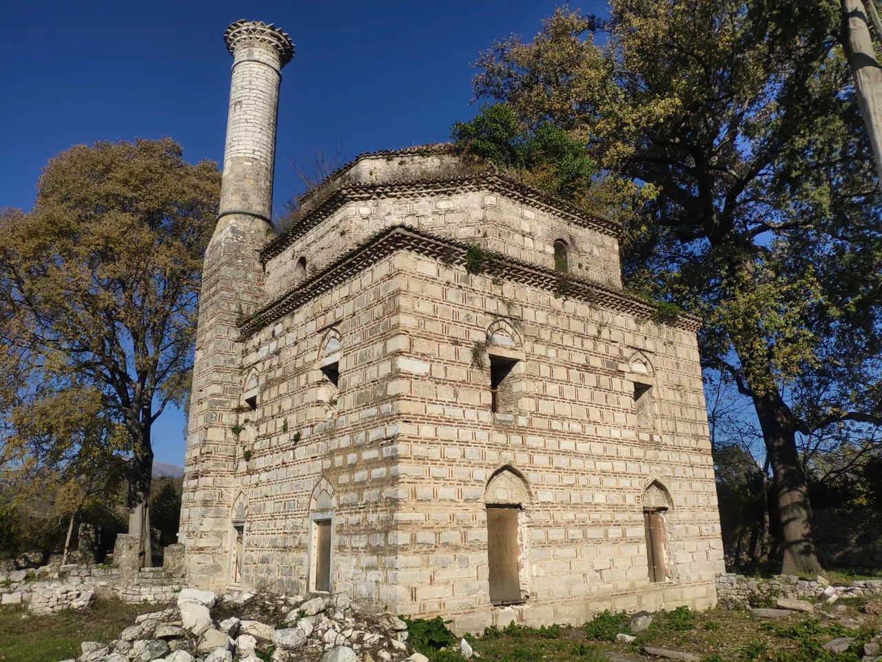

Faik Pasha Mosque
There is a story about the man who built this mosque. Faik Pasha was the Ottoman vizier who took Arta in 1449, and he built his mosque in the outlying district known as Top-Alti — a Turkish phrase meaning 'within cannon range of the castle,' which tells you something about the way Ottoman administrators thought about urban space. After the mosque was finished, Faik Pasha appointed an imam to lead prayers. The imam died. Unable to find a worthy replacement, according to oral tradition recorded in the 18th century, Faik Pasha did something unusual: he resigned his military commission and became the imam himself, serving in the role for about forty years until his death in 1499. Whether the story is true or embellished, it is the kind of detail that makes a person out of a name on a building.
A Church Beneath a Mosque
The Faik Pasha Mosque was almost certainly built on the site of an earlier Byzantine church dedicated to Saint John the Baptist. This layering is common across the former Ottoman world, and the interior of the mosque still shows it: the mihrab, the prayer niche indicating the direction of Mecca, occupies the center of the southern wall, while the remains of an iconostasis — the screen that separated the nave from the altar in Orthodox churches — are visible on the eastern wall. Two religions left their structural logic in the same room. Building materials for the porch, which has since collapsed, came from the nearby Monastery of Panagia Pantanassa, founded in the mid-13th century by Michael II Doukas, the Despot of Epirus. The mosque was assembled partly from the bones of what preceded it.
When It Was Built
The date of construction is genuinely uncertain — two scholarly hypotheses exist and neither has been definitively resolved. One tradition, backed by the Metropolitan of Arta Seraphim of Byzantium, places the mosque's foundation during the reign of Sultan Mehmed II the Conqueror, sometime around 1455. The other, and perhaps more plausible, hypothesis dates it to 1492 or 1493, during the reign of Bayezid II. The Ottoman historian Aşıkpaşazade referred around 1478 to the mosque as being still in draft form, which argues against the earlier date. The founding charter (wakf) of Faik Pasha's complex — including the mosque, an imaret (a soup kitchen serving the poor and travelers), a madrasa (a religious school), and baths — dates from 1493. The complex was an institution, not just a building: it drew income from agricultural lands in surrounding villages and from properties as far away as Thessaloniki.
The Landscape Around It
Early 19th-century travelers who passed through this part of Epirus left useful descriptions of the mosque's setting. The French physician François Pouqueville noted Persian reeds, olive trees, lemon trees, and orange trees growing around the site — a lush pocket of cultivation on the Arachthos riverbank. In 1805, the British geographer William Martin Leake described it as rich in hazel trees. The area was known as Marati, derived from the name of an Ottoman Muslim village (Karye-i Imaret) recorded by the traveler Evliya Çelebi. The mosque stood about 1.5 kilometers north of the Bridge of Arta, close to the river, in a district the Ottomans defined by its relationship to the castle's guns — within range, but not inside the walls.
A Siege and an Entrenchment
During the Greek War of Independence in 1821, the mosque acquired another chapter of history. In November of that year, Greek fighters including Karaiskakis and Markos Botsaris — two of the most celebrated commanders of the revolution — used the mosque as an entrenchment camp with a few hundred men, holding off assaults by the Ottoman garrison on November 12, 1821. The solid walls of a 15th-century Islamic complex became a defensive position in a Greek uprising against Ottoman rule, a reversal that says something about the way buildings outlast the politics that built them. The mosque ceased functioning as a place of worship in the 1820s, around the time those events unfolded.
What Remains
The mosque today is a roofless ruin under active archaeological study. The square prayer hall — 11.5 meters per side — still stands to significant height, its dome gone but its walls intact enough to read. The cylindrical brick minaret at the northwest corner survives up to the balcony level, probably rebuilt in the 19th century. A few dozen meters to the northwest, the remains of the baths — the only other surviving element of the original complex — lie partially excavated. Restoration studies were approved by Greece's Central Archaeological Council in 2019, and the work was put out to tender in 2022. The site is quiet now, shaded and surrounded by vegetation, the Arachthos nearby. Aktion National Airport (LGPZ) is approximately 40 kilometers to the southwest. The mosque sits close to the riverbank north of the city, a location best understood from the air as part of the string of monuments — castle, bridge, church, mosque — that define the historic geography of Arta.
From the Air
The Faik Pasha Mosque sits at approximately 39.1658°N, 20.9728°E, on the right bank of the Arachthos river, about 1.5 km north of the Bridge of Arta. Nearest major airport is LGPZ (Aktion National Airport), approximately 40 km to the southwest across the Gulf of Ambracia. The site is best viewed at 1,500–2,500 feet; the mosque's distinctive square footprint and surviving minaret stub are visible among riverbank vegetation in clear conditions. The Bridge of Arta and the castle hill are nearby visual references.
Nearby Stories
- Battle of Karpenisi 13 km away
- Castle of Santa Maura 17 km away
- Prousou Monastery 21 km away
- Paxos 22 km away
- Dodona 22 km away
- Meteora: The Monasteries Built on Impossible Pillars 42 km away
- Achilleion (Corfu) 47 km away
- SM UC-38 67 km away