Fiery Cross Reef
In 1860, the British tea clipper Fiery Cross struck a submerged reef in the South China Sea and sank. The wreck gave the atoll its name, and for more than a century that was all there was to the place: a hazard on nautical charts, a warning to navigators threading the treacherous waters of the Spratly Islands. Today, the reef bears a 677-acre artificial island bristling with hangars, radar arrays, and a runway long enough to land strategic bombers. Few places on Earth have undergone a more dramatic transformation from maritime footnote to geopolitical flashpoint.
From Shipwreck to Sovereignty Claim
Lieutenant J. W. Reed surveyed the atoll in 1867 and found the remains of the Fiery Cross along with another vessel, the Meerschaum. The reef lingered in obscurity until 1934, when China's Land and Water Maps Inspection Committee translated the English name as Shizi Huo Jiao, literally "Fire Cross Reef." In 1947, the government renamed it Yongshu Reef. Local fishermen had their own name: Tuwu. These layers of naming hint at the deeper contest. China, Taiwan, the Philippines, and Vietnam all claim sovereignty over the reef, each citing different historical threads to justify possession of what nature made barely habitable.
The Science Station Gambit
China's path to occupying Fiery Cross Reef began with an unlikely tool: oceanography. In 1987, Beijing submitted the name "Yongshu Jiao" to UNESCO as a candidate site for a Global Sea Level Observing System monitoring station. The scientists reviewing the proposal had no idea where Yongshu Jiao actually was, nor any awareness of the territorial disputes surrounding it. By April 1987, China had chosen the reef for a weather station, citing its size and relative isolation from other contested features. Vietnam objected immediately. When Vietnamese ships carrying construction materials approached the reef in January 1988, the confrontation escalated into the Johnson South Reef Skirmish that March, a brief but bloody naval engagement that left over 60 Vietnamese sailors dead.
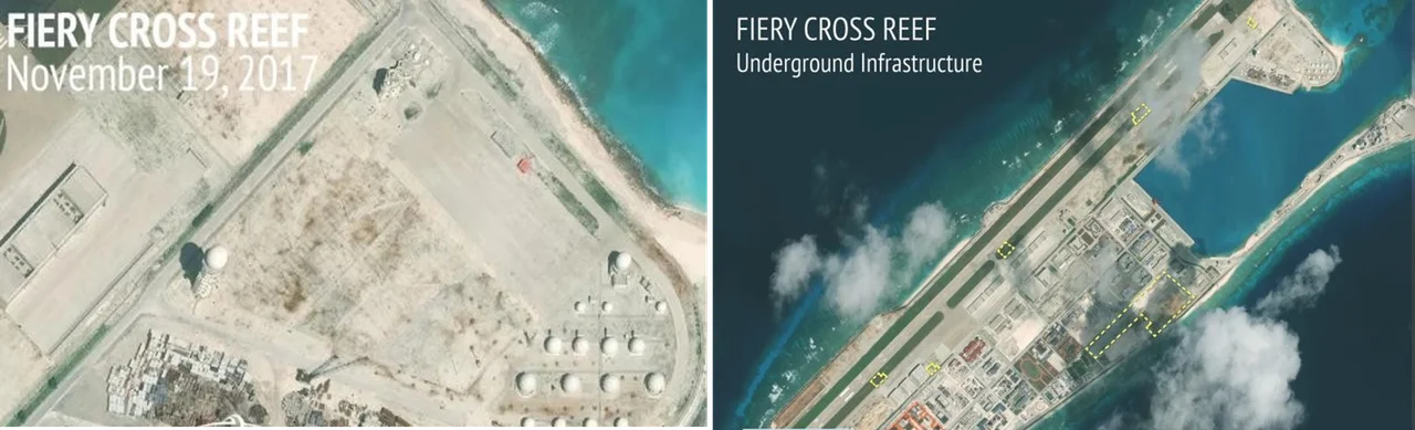
Sand into a Fortress
The reef's real metamorphosis began in 2014, when China commenced massive land reclamation. Dredgers pumped sand from the seabed onto the coral, building up an artificial island acre by acre. By January 2016, a 3,125-meter runway stretched across the new landmass, and two civilian aircraft, one from China Southern Airlines and the other from Hainan Airlines, completed test landings. A Chinese military jet followed in April 2016. The Center for Strategic and International Studies called Fiery Cross "the most advanced of China's bases" in the disputed South China Sea, noting twelve hardened shelters with retractable roofs for mobile missile launchers, hangars for up to 24 combat aircraft and four larger planes, and early warning radar installations. By late 2016, photographs revealed anti-aircraft weapons and a close-in weapon system for missile defense.
A Rock by Any Other Name
On July 12, 2016, the Permanent Court of Arbitration weighed in. The tribunal concluded that Fiery Cross Reef does contain naturally formed areas of land above water at low tide, meeting one definition of a territorial feature under the United Nations Convention on the Law of the Sea. But it classified the high-tide features as "rocks that cannot sustain human habitation or economic life of their own," entitled only to a 12-nautical-mile territorial sea rather than a full exclusive economic zone. The ruling drew a sharp legal line: no matter how much concrete and steel China stacked on the reef, the surrounding waters would not become Chinese territory under international law. China rejected the ruling entirely.
The View from Above
From the air, Fiery Cross Reef is unmistakable. The turquoise shallows of the original atoll frame a geometric island of gray concrete and white sand, the long runway bisecting it like a scar. The transformation from submerged coral to military base happened so quickly that satellite imagery archives read like time-lapse photography. Where seabirds once rested on exposed rock at low tide, radar domes now rotate, and aircraft shelters stand in neat rows. The reef's story captures the central paradox of the South China Sea disputes: features too small to sustain a village have become stages for rivalries between nations, their significance measured not in acres of dry land but in the thousands of square miles of ocean they are meant to control.
From the Air
Fiery Cross Reef sits at approximately 9.62°N, 112.97°E in the western Spratly Islands. From cruising altitude, the artificial island is visible as a stark geometric shape against turquoise shallows. The 3,125-meter runway is oriented roughly northeast-southwest. No civilian ICAO code is assigned. The nearest major airports are in Vietnam (VVTS/Tan Son Nhat, Ho Chi Minh City, ~600 nm northwest) and the Philippines (RPVM/Mactan-Cebu, ~550 nm east). Expect potential military activity and restricted airspace in the vicinity.
Nearby Stories
- Spratly Islands 52 km away
- Philippines and the Spratly Islands 82 km away
- Spratly Island 98 km away
- Taiping Island 158 km away
- Raid on Griessie 246 km away
- HMS Pelorus (1808) 251 km away
- South-East Asian Theatre of World War II 274 km away
- Ile des Cendres 387 km away