Philippines and the Spratly Islands
In May 1956, Tomas Cloma sailed into the South China Sea with his brothers and a crew of forty. A fishing vessel owner and director of the Philippine Maritime Institute, Cloma had no army behind him, no government mandate, and no legal precedent for what he was about to do. Finding the scattered islands unoccupied, he planted a flag, declared a new municipality called Kalayaan, meaning "freedom," and sent a notice to the world. The Philippine government initially distanced itself from Cloma's claim. Decades later, it would adopt his vision almost entirely.
A Map from 1734
The Philippines traces its historical connection to the Spratly Islands back further than Cloma's adventure. In 1734, the Spanish colonial government published the Velarde map, which detailed the territories under full sovereign control of Spanish Philippines. The map included Scarborough Shoal, called Panacot in the indigenous language, and referenced the Kalayaan or Spratly Islands. Whether a colonial-era map constitutes a valid sovereignty claim under modern international law remains hotly debated. But the Philippines cites it as evidence that awareness of and authority over these waters predates the claims of rival nations by centuries.
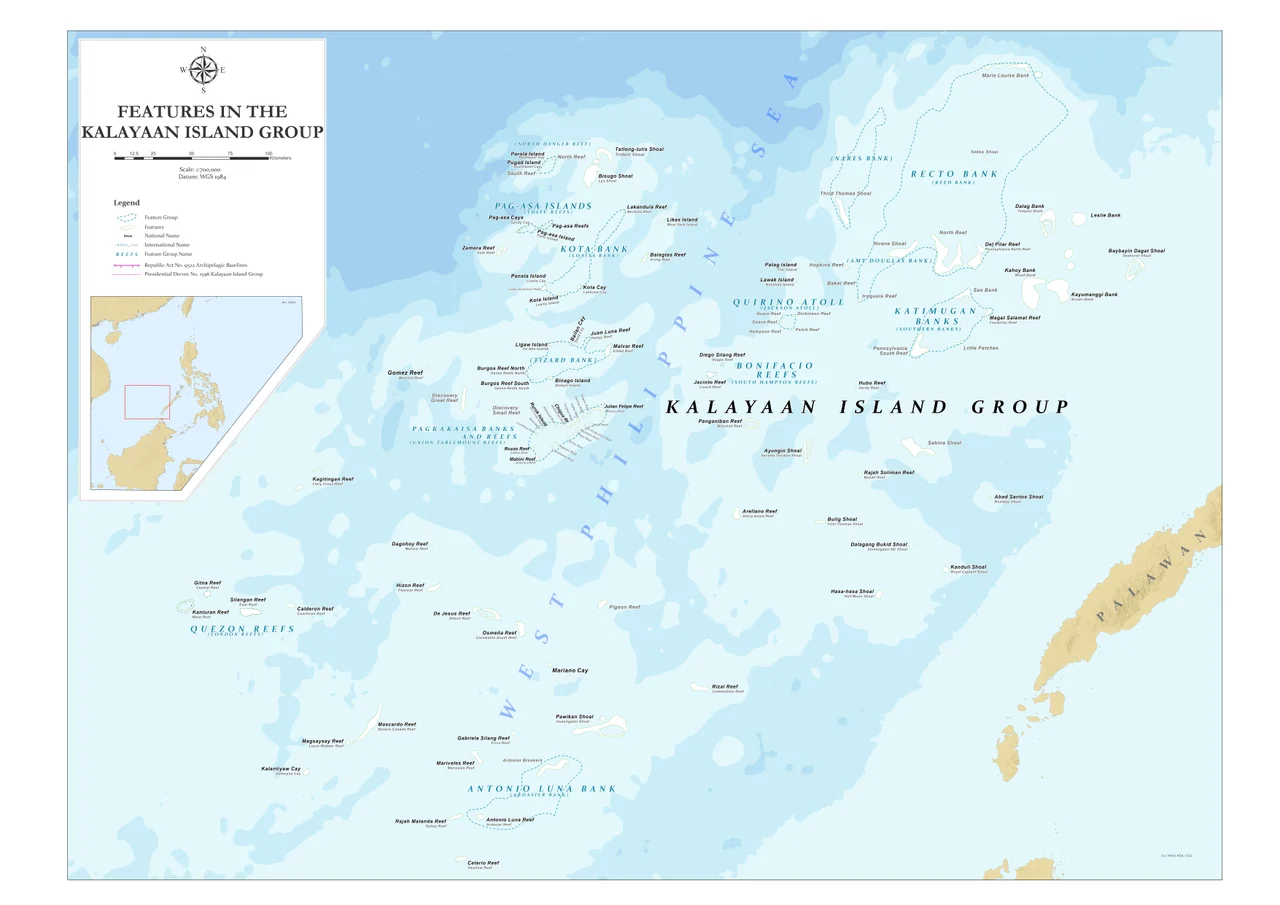
Eleven Outposts in a Vast Sea
Today the Philippines occupies and controls eleven features in the Spratlys: eight islands and three reefs. By comparison, Vietnam holds six islands, seventeen reefs, and three banks. China controls seven reefs it has transformed into artificial islands. Taiwan administers the largest naturally occurring island, Taiping. Malaysia holds five reefs, and Brunei claims a single feature. The Filipino garrisons on these outposts range from small Marine detachments on concrete platforms to the more developed settlement on Thitu Island, also known as Pag-asa, the only Philippine-occupied island with a civilian population, a school, and an airstrip. Pag-asa serves as the administrative center of the Municipality of Kalayaan, making it the only municipality in the Philippines with just a single barangay.
The Hague Ruling
In January 2013, the Philippines took a step no other Spratly claimant had attempted: it initiated formal arbitration proceedings against China's nine-dash line claim under the United Nations Convention on the Law of the Sea. The case was heard by a tribunal constituted under Annex VII of UNCLOS, with the Permanent Court of Arbitration serving as registry. On July 12, 2016, the tribunal ruled overwhelmingly in the Philippines' favor, declaring that China had no legal basis for historic rights claims within the nine-dash line. It also found that several features China occupied were low-tide elevations incapable of generating territorial entitlements. China rejected the ruling, calling it a "sham," and has refused to comply. The decision nevertheless reshaped the diplomatic landscape, giving smaller claimant states a legal framework to challenge China's expansive assertions.
Fishermen and Confrontations
Beyond the legal arguments, the dispute plays out daily on the water. Chinese fishing vessels operate throughout the South China Sea, some entering what the Philippines considers its internal waters in the Sulu Sea. The Philippines generally tolerates Chinese fishing in contested areas near the Spratlys, but arrests vessels caught engaging in illegal practices such as poaching endangered species or using cyanide. These encounters can escalate quickly. Philippine Navy and Coast Guard patrols have intercepted Chinese boats carrying giant clams, sea turtles, and coral taken from Philippine-claimed reefs. Each arrest becomes a diplomatic incident, each released fisherman a concession weighed against the risk of confrontation with a far larger military power.
A Question Still Open
The Philippines' position in the Spratly Islands sits at the intersection of international law, military reality, and the daily lives of Filipino fishermen and soldiers stationed on remote outposts. From Tomas Cloma's impulsive flag-planting to the landmark 2016 arbitration ruling, Manila has pursued its claims through legal channels rather than military force, a strategy shaped partly by principle and partly by the enormous disparity in naval power between the Philippines and China. Whether law or power ultimately determines who controls the Spratly Islands remains the defining question of the South China Sea. The fishermen who depend on these waters for their livelihoods are still waiting for an answer.
From the Air
The Philippine-claimed Spratly features are centered around approximately 9.71°N, 114.29°E, scattered across the South China Sea roughly 500 km west of Palawan. Thitu Island (Pag-asa) has an unpaved airstrip (Rancudo Airfield) at approximately 11.05°N, 114.28°E. The nearest major Philippine airport is Puerto Princesa (RPVP), about 270 nautical miles to the east. Expect potential military patrols and restricted zones throughout the area.
Nearby Stories
- Taiping Island 40 km away
- Mischief Reef 65 km away
- Fiery Cross Reef 104 km away
- HMS Pelorus (1808) 161 km away
- Tango Maru 217 km away
- Spratly Island 238 km away
- Kashmir Princess 241 km away
- 2019 Reed Bank Incident 268 km away