.jpg)
Mischief Reef
At high tide, there was nothing here. Mischief Reef, named after a clipper ship that sailed the South China Sea in the 1850s, was a low-tide elevation, a ring of coral barely breaking the surface around a shallow lagoon. It generated no territorial rights under international law. It supported no permanent population. It appeared on nautical charts primarily as a hazard to navigation, part of the aptly named Dangerous Ground in the eastern Spratly Islands. Then, beginning in 1995, structures appeared on stilts above the water. By 2016, a 1,379-acre artificial island encircled the lagoon, complete with a 2,644-meter runway, harbor facilities, and weapons systems. What international law said could not be claimed had been, quite literally, built.
Stilts, Buoys, and Concrete
China's method for establishing presence on disputed reefs followed a pattern the Philippines came to know well. First came buoys. Then concrete markers. Temporary wooden or bamboo shelters followed, and permanent structures went up last. The Philippines learned to destroy buoys and markers before they could escalate, but at Mischief Reef the strategy failed. In 1994 and 1995, China built initial structures on stilts, describing them as shelter for fishermen when the Philippine government protested. In 1999, more structures appeared, prompting another round of diplomatic objections from Manila. The reef sits 239 kilometers west of Palawan Island, well within the Philippines' exclusive economic zone and traditional fishing grounds, and 1,109 kilometers south of China's Hainan Island. Geography favored the Philippine claim. Geopolitics did not.
The Hague Rules, Beijing Builds
On July 12, 2016, the Permanent Court of Arbitration in The Hague delivered a landmark ruling. The tribunal concluded that China's nine-dash line, the sweeping claim to most of the South China Sea, had no basis in international law. Mischief Reef, the court found, was a low-tide elevation that could not generate entitlement to a territorial sea, exclusive economic zone, or continental shelf. The reef belonged to the Philippine continental shelf. The ruling was clear and legally binding. China rejected it. By the time the decision was announced, land reclamation was already well advanced. A China Southern Airlines passenger jet had conducted a civilian test flight to the new runway the day after the ruling. By late 2016, photographs showed anti-aircraft weapons and missile-defense systems installed on the artificial island.
A Village on a Reef
In December 2012, before the massive reclamation began, China established the Mischief Village Committee as part of Nansha District, Sansha City, Hainan Province. Fifty-three fishermen who guarded the reef became the first registered villagers, their homes and committee offices located on a fishing boat called the Qiongfuhua No. 01, anchored in the lagoon. The plan had originally called for a cement platform to be built in Sanya, transported to the reef, and fixed to the atoll through pre-embedded pile foundations, creating a structure with hundreds of rooms, toilets, air conditioning, and bathrooms. That plan was overtaken by the far more ambitious land reclamation that followed. By June 2015, after reclamation was complete, an office building for the Mischief Community Residents Committee stood on the artificial island, along with bungalows for the villagers. The southernmost settlement administered by the People's Republic of China now sits on what international law defines as Philippine territory.
Dangerous Ground
The name suits the place. Dangerous Ground is the nautical term for the maze of reefs, shoals, and atolls in the eastern Spratly Islands where ships have come to grief for centuries. The political waters are equally treacherous. Mischief Reef is claimed by the Philippines, China, Taiwan, and Vietnam. It sits in an area believed to be rich in unexplored oil and gas fields. In early 2021, satellite imagery confirmed new construction on the reef, including a radome and possible antenna mount. The transformation from submerged coral to fortified outpost took barely two decades. From the air, the reef is now unmistakable: a massive artificial landmass in waters that once offered nothing but open sea, a physical assertion of sovereignty that no court ruling has reversed.
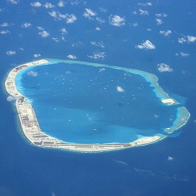
From the Air
Coordinates: 9.92°N, 115.53°E, in the Spratly Islands of the South China Sea. From altitude, the artificial island is clearly visible as a large white-and-gray landmass with a prominent runway (approximately 2,700 meters), harbor facilities, and structures encircling a turquoise lagoon. The island stands in stark contrast to the surrounding deep blue ocean. Nearest Philippine airport is Puerto Princesa (RPPS) on Palawan, approximately 240 km to the east. Caution: the area is heavily militarized and subject to Chinese air defense identification requirements.
Nearby Stories
- Whitsun Reef Incident 35 km away
- Second Thomas Shoal 40 km away
- Taiping Island 68 km away
- Sabina Shoal 68 km away
- Japanese Cruiser Atago 133 km away
- Emilio S. Liwanag 163 km away
- 2019 Reed Bank Incident 178 km away
- Fiery Cross Reef 219 km away