The Bridge Built for a Lake That Never Came
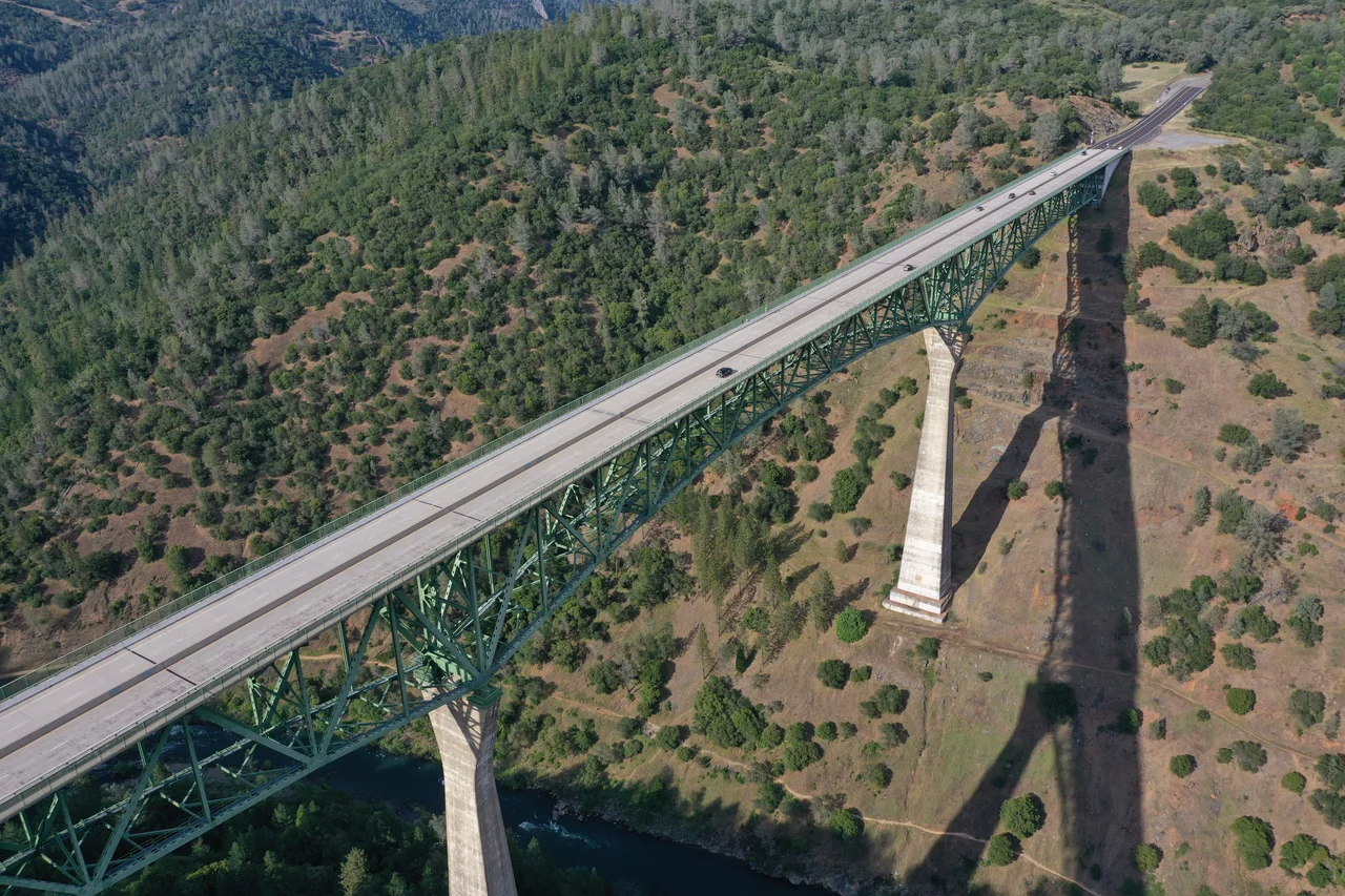
Somewhere in the Sierra Nevada foothills, a four-lane bridge crosses a canyon so deep that the river below looks like a pencil line drawn on stone. The Foresthill Bridge hangs 730 feet above the North Fork of the American River, making it the tallest bridge in California and the fourth tallest in the United States. But the remarkable thing about this bridge is not its height. It is why it was built. In the late 1960s, the Bureau of Reclamation planned to dam the American River canyon and flood it into a massive reservoir. The bridge was supposed to cross above the surface of that lake, replacing a lower road that would vanish under hundreds of feet of water. The dam was never finished. The lake never formed. And the Foresthill Bridge has spent more than fifty years spanning a canyon of open air and whitewater instead of the placid reservoir it was designed to overlook.
Steel from Across the Pacific
The bridge's main span was fabricated in 1971 by Kawasaki Heavy Industries in Japan, then shipped across the Pacific and assembled on site by Willamette Western Contractors. Two 403-foot concrete piers anchor the structure, supporting a Warren deck truss superstructure with a central span of 862 feet. The total length stretches 2,428 feet from abutment to abutment. When it opened to traffic on Labor Day 1973, it was the second-highest bridge in the world. The Bureau of Reclamation paid $13 million for it -- a figure that, even adjusted for inflation, represented a fraction of the cost when a seismic retrofit between 2011 and 2015 ran to $74.4 million. That retrofit reinforced more than the steel. It reinforced the bridge's permanence in a landscape whose plans had long since changed.
The Dam That Shook Apart
The Auburn Dam was supposed to be enormous -- more than 600 feet of concrete rising from the canyon floor, backing up a reservoir that would stretch for miles into the foothills. Construction began in 1975, two years after the bridge opened. Then, on August 1 of that year, a magnitude 5.7 earthquake struck near Oroville, roughly 60 miles to the north. The jolt sent shockwaves through more than the ground. Engineers discovered that the dam site itself sat near a fault system, and the project stalled as seismic studies multiplied and costs spiraled. Environmental concerns mounted alongside the geological ones: the reservoir would drown whitewater rafting runs, inundate archaeological sites, and destroy long stretches of the wild and scenic American River forks. Debate dragged on for decades. In 2008, the Bureau of Reclamation formally abandoned its water rights for the project. The canyon stayed wild. The bridge stayed high and dry.
A Canyon's Unlikely Lifeline
What might have been a footnote to a dam became a lifeline for a community. Foresthill, a small town of roughly 1,500 people nestled in the pine-and-oak woodland above the canyon, depends on the bridge for its primary connection to Auburn and the wider world. Without it, the drive requires a long detour through winding mountain roads. The bridge carries residents to work and school, brings tourists to the surrounding Tahoe National Forest, and serves as the gateway for hikers, mountain bikers, and rafters heading into the American River canyon below. Pedestrians can walk its full length in both directions, and those who do experience something few bridges offer: a walk at the height of a 70-story building, with nothing but wind and the faint sound of rapids far beneath.
Hollywood's Favorite Abyss
A bridge this tall inevitably attracts cameras. In the opening sequence of the 2002 action film XXX, Vin Diesel's character drives a stolen red Chevrolet Corvette off the bridge deck, leaping from the car in midair and parachuting to accomplices waiting at the bottom of the canyon. The scene was not entirely fiction -- the bridge has long drawn BASE jumpers and bungee enthusiasts, though such activities are not officially sanctioned. It also appeared in a montage sequence in the romantic comedy The Ugly Truth and has served as a backdrop for exercise equipment advertisements, its vertiginous depth apparently conveying the idea of physical ambition. For most visitors, though, the drama requires no script. Standing at the railing and looking straight down at 730 feet of empty space communicates something that no camera angle can fully reproduce.
From the Air
Located at 38.92N, 121.04W in Placer County, spanning the North Fork American River canyon between Auburn and Foresthill. The bridge's 2,428-foot steel truss structure is clearly visible from 3,000-5,000 feet AGL, its deck cutting a straight line across the deeply carved canyon. Auburn Municipal Airport (KAUN) lies approximately 3nm to the southwest. The canyon itself runs roughly north-south and offers dramatic terrain for visual sightseeing. Pilots should note that the bridge deck sits at approximately 1,400 feet MSL while the canyon rim rises to roughly 2,100 feet MSL on both sides.
Nearby Stories
- The Only Home She Ever Owned 4.7 km away
- The Gate Between Two Rivers 10 km away
- The Middle Mountains Nobody Can Reach 15 km away
- The Image That Would Not Be Erased 17 km away
- Sutter National Wildlife Refuge 19 km away
- Donner Pass 48 km away
- New Melones Dam 81 km away