The Gate Between Two Rivers
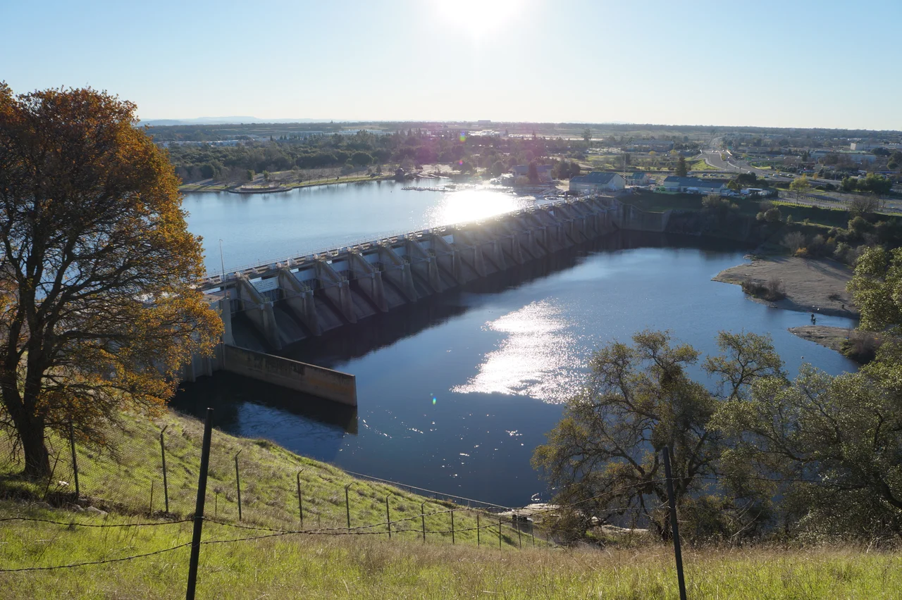
Eighteen radial gates hold back the American River east of Sacramento, and fourteen of them still wear the coating they received in 1955. That detail -- mundane, almost bureaucratic -- reveals something essential about Nimbus Dam. It is not a monument. It is not scenic in the way Folsom Dam, its larger partner upstream, commands attention. Nimbus is the workhorse, the afterthought that became indispensable, the structure built to regulate what Folsom Dam unleashed and to divert what California's Central Valley demanded. For seventy years those gates have opened and closed with the seasons, releasing Sierra snowmelt in summer, holding back winter floods, and shaping the lower American River into something it never was naturally: a managed resource.
Folsom's Quieter Partner
Congress authorized Nimbus Dam in 1949 as part of the Central Valley Project, the sprawling federal water system that irrigates one of the most productive agricultural regions on Earth. Its purpose was specific: serve as a regulating reservoir for Folsom Dam, seven miles upstream, and provide a diversion pool for the Folsom South Canal. Construction began in 1952. By 1955, the dam was operational -- 87 feet tall, 1,093 feet across, impounding roughly 8,700 acre-feet of water in the narrow reservoir that would become Lake Natoma. Where Folsom Dam stores water on a grand scale, Nimbus smooths the release. It is the valve on the pipe, ensuring that downstream flows remain steady regardless of how Folsom's operators manage their larger reservoir above.
Power from the Penstocks
On the dam's north side, two turbines draw water through six penstocks, each about 47 feet long, generating a combined 15,500 kilowatts of electricity. That is modest by hydroelectric standards -- enough to light roughly 200,000 old-fashioned 100-watt bulbs -- but it serves as reliable base load power, the kind that hums along around the clock without the intermittency of wind or solar. The Western Area Power Administration markets what Nimbus and Folsom generate together. Below the powerplant, the Folsom South Canal diverts water southward, carrying it roughly 27 miles to an area northeast of Lodi. The canal once cooled the reactors at Rancho Seco, SMUD's nuclear power plant, before that facility shut down in 1989. Today the canal still flows, feeding irrigation ditches and municipal systems across Sacramento County's southern reach.
The Salmon That Lost Their Highway
Before Nimbus Dam existed, Chinook salmon and steelhead had access to 125 miles of spawning habitat in the American River watershed, threading their way up into Sierra Nevada tributaries where cold, gravelly streams offered ideal conditions. The dam severed that migration in a single construction season. Suddenly, the fish that had navigated this corridor for millennia found a concrete wall where a river used to be. The Bureau of Reclamation's answer came in 1955: the Nimbus Fish Hatchery, built just downstream, where salmon climb a fish ladder, are artificially spawned, and their offspring released back into the river. It was a technological substitute for a natural process -- functional but fraught with complications that persist to this day.
Cold Water and Closed Banks
Lake Natoma, the reservoir behind Nimbus Dam, has never been a natural producer of fish. The water cycles through too quickly, flushing plankton before it can sustain a food web, and the temperatures stay too cold for warmwater species. The California Department of Fish and Game stocks the lake annually with 20,000 to 30,000 catchable trout, creating a fishery that exists entirely by human design. Downstream, the story grew more complicated over time. Anglers flocked to the basin below the dam after the hatchery opened, but decades of heavy fishing eroded the spawning beds that salmon needed once they passed the fish ladder. In March 2018, the state permanently closed the Nimbus Basin to all fishing -- a recognition that the river's biological needs had finally outweighed its recreational ones.
Sierra Snowmelt and Sacramento Sprawl
Nearly half of Sacramento's annual precipitation falls in a 60-day winter window, while summer contributes barely one percent. In the American River Basin, roughly 40 percent of yearly runoff comes from melting Sierra snowpack, which means Nimbus Dam's operators spend the dry months releasing stored water to keep the lower river alive. As Sacramento County has sprawled eastward, the demands on that water have grown. Environmental degradation along the lower American River prompted the County of Sacramento to convene a Water Forum in 1993, bringing together water managers from Sacramento, El Dorado, and Placer counties. The Water Forum Agreement, signed in April 2000, committed the region to habitat management, water conservation, and flow standards designed to sustain both human communities and the river's ecology through 2030. Nimbus Dam sits at the center of that tension -- the infrastructure that makes suburban Sacramento possible, and the obstacle that the river's original inhabitants can no longer pass.
From the Air
Nimbus Dam is located at 38.636N, 121.220W on the American River, approximately 6 miles downstream of Folsom Dam. Lake Natoma, the narrow reservoir it impounds, is visible as a distinct blue ribbon running east-west between the dam and Folsom Dam. Sacramento Mather Airport (KMHR) lies roughly 5nm to the south; Sacramento Executive Airport (KSAC) is about 12nm west-southwest. From 2,000-3,000 feet AGL, the dam's 18 radial gates and the fish hatchery complex on the south bank are clearly visible, as is the Folsom South Canal diverging southward from the dam's west end.
Nearby Stories
- The Welshman Who Named a Town After a Hole in the Ground 4.4 km away
- The Image That Would Not Be Erased 11 km away
- The Town Beneath the Water 13 km away
- Rio Vista, California 18 km away
- Sutter National Wildlife Refuge 28 km away
- New Melones Dam 42 km away
- Donner Pass 56 km away
- The Emporium 72 km away