Fort Eben-Emael: The Largest Fort in the World
Walk the grass on top of Fort Eben-Emael today and the surface seems almost agricultural - low mounds, neat concrete cupolas, a few rusted observation domes pocked with bullet scars. The drama is underneath your feet. Four kilometres of galleries run through the marl beneath the hill, connecting combat blocks, magazines, an underground power station and barracks for over a thousand men. The fortress was designed to be a small city sealed against the world, with its own hospital, air-filtration system and electrical grid. For five years it was. For one morning in May 1940, it was the proof that the age of the great fortress was over.
A Cliff Made on Purpose
In the 1920s, Belgian engineers carved a deep channel through the Caestert Plateau to keep the new Albert Canal entirely inside Belgian territory. The cut left a sheer face above the water, and at the lip of that artificial cliff, between 1932 and 1935, they hollowed out a fortress. The location had been recommended decades earlier by General Henri Alexis Brialmont, the Belgian engineer whose Liege forts had stunned German planners in 1914. The new fort - a flattened diamond about 200 metres on its long axis - was the largest of four constructed in the 1930s as Position Fortifiee de Liege I, the modern defensive line meant to anchor Belgium's defences against another German thrust through the Maastricht gap.
What Sixty-Four Guns Look Like
Two retractable 120mm guns sat in armored cupolas with a range of eighteen kilometres and full 360-degree traverse. Sixteen 75mm artillery pieces - some in cupolas, some in casemates aimed north toward Maastricht and south toward Vise - could blanket the bridges over the Albert Canal. Twelve high-velocity 60mm anti-tank guns covered the ditches and approaches. Twenty-five twin machine-gun mounts watched the land sides. Casemates named Maastricht I and II, Vise I and II, Mi-Nord and Mi-Sud each housed clusters of weapons made by Belgium's Fonderie Royale des Canons in Liege. The turrets were so well-engineered that gunners did not need hearing protection when firing. The roof was 4 metres of reinforced concrete; the walls and vaults of the deep galleries, more again. Minefields, anti-tank ditches, 6-metre walls and fifteen searchlights covered the three approaches not protected by the canal cliff.
The Garrison
Major Jottrand commanded around 1,200 men, organized into three groups. Two hundred technical personnel - cooks, medics, weapons technicians, clerks - lived at the fort full-time. The other thousand were artillerymen split into two five-hundred-man rotations who swapped weekly between Eben-Emael and the village of Wonck five kilometres away. Most were Belgian reservists called up after Germany invaded Poland in September 1939. Their training was as artillerymen, narrowly focused on their guns. Infantry skills, the doctrine said, were not their job. Belgian planners had decided the fort would fight a delaying action and then the garrison would retire west to join the main Allied line on the Dyle River. Nobody planned for the enemy to be on the roof.
Eighty-five Men in Silent Aircraft
At dawn on 10 May 1940, eighty-five paratroopers of Koch's Assault Detachment (Sturmabteilung Koch) — engineers from the 7th Flieger Division — set off in eleven DFS 230 gliders toward the fort. One glider's tow rope snapped over Germany; seventy-eight men arrived in the first wave, with their commander landing later on a replacement glider. They carried something the world had not seen on a battlefield: shaped charges - hollow explosives that focused a jet of molten metal through armored steel. They worked through the cupolas methodically while the artillerymen below tried to understand what was happening above their heads. The next morning, after a relief column finally fought through, the garrison surrendered. Twenty-three Belgians had been killed and fifty-nine wounded. The largest fort in the world had been disabled by a force smaller than a peacetime company. Its loss, Wikipedia notes drily, was a hard blow from which the Belgian Army did not recover.
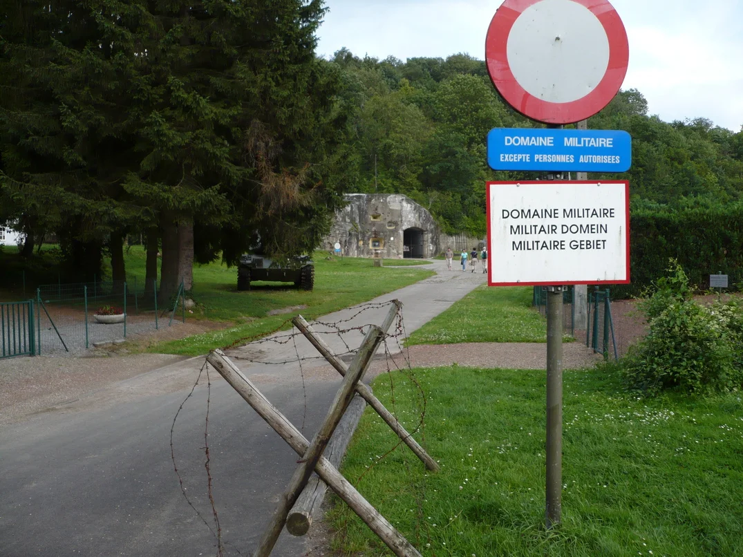
Going Inside
The fortress is still property of the Belgian Army, but it has been preserved as a museum by the Association Fort Eben-Emael, and on certain weekends the gates open to visitors. You can descend the cool, slightly damp galleries, pass the underground hospital and the powerhouse, and emerge inside the very cupolas the Germans cracked. The shaped-charge holes are still there, lipped outward where the molten jets punched through. Bullet scars on the surface concrete have weathered to a pale brown. Nearby, the canal still slides past the artificial cliff, barges pushing north toward Maastricht just as the planners imagined - except no one is firing on them now, and the great fort above watches in silence.
From the Air
Fort Eben-Emael sits at 50.797N, 5.681E, atop the Caestert Plateau where the Albert Canal cuts north toward Maastricht. From the air, look for the distinctive deep canal cutting at the Belgian-Dutch border and the slightly raised plateau immediately west of it - the fort is the roughly diamond-shaped area of grass and concrete cupolas on that plateau. Nearest airports: Maastricht-Aachen (EHBK) 15km north, Liege (EBLG) 25km southwest, Brussels (EBBR) 90km west. Clear-weather day VFR offers the best detail; the canal and the road to Vise help orient.
Nearby Stories
- Battle of Hurtgen Forest 2.5 km away
- Hoge Kempen National Park 9.7 km away
- Battle of Hannut 14 km away
- Ted Swales 15 km away
- Rheindahlen 20 km away
- Marcinelle Mining Disaster 59 km away
- Fort Jeanne d'Arc 149 km away
- Marmoutier Abbey 210 km away