Rheindahlen
Two hundred thousand years ago, something that may have been Homo heidelbergensis or possibly Neanderthal Man chipped a hand hammer out of stone in the clay soil of what is now the southern edge of Rheindahlen. The hammer turned up in a 1994 archaeological dig near an old brickworks, and in 2003 the town centre put up a thirteen-times-enlarged bronze replica of it. That bronze sits in a small Lower Rhine town that, on most maps, looks like a quiet suburb of Mönchengladbach. The truth is more complicated. Rheindahlen has been a Stone Age site, a medieval mayoralty, a Prussian town renamed by imperial decree, and, for more than half a century, the headquarters of the British armed forces in Germany.
The Hollow
The original name was Dale, then Dalen, then Dahlen, and finally, by an act of the Prussian king Wilhelm I dated 24 December 1877 and published in February 1878, Rheindahlen. The renaming was completely prosaic. By the 1870s the German postal service had too many Dahlens, Dalheims, Dalems and Dalhems to keep them straight, and the one in the Rhine Province needed to be distinguished from another Dahlen in Saxony. So Rhein was glued on the front. The root word itself is older and gentler: Delle, hollow, a reference to the slight depression in the land where the village settled. Even the name remembers the shape of the ground.
Stones in the Clay
Rheindahlen has been famous in German archaeology since 1908. The clay soils preserve organic material in a way that drier sites do not, and the area has yielded one of the richest concentrations of Old and New Stone Age remains in northwestern Europe. Excavations in the southern part of the modern town have helped reconstruct how Neanderthal and earlier hominid groups hunted and settled the Lower Rhine plain between roughly 220,000 and 120,000 BC. Layered above this is the Roman period. A Roman settlement existed in the Hardt Forest to the north from at least the third century CE. It was rediscovered by accident in 1954 during the construction of the NATO headquarters northwest of town. Excavations across the borough have turned up traces of more Roman occupation, including a metre-high matrona stone from the second century, uncovered in 1961.
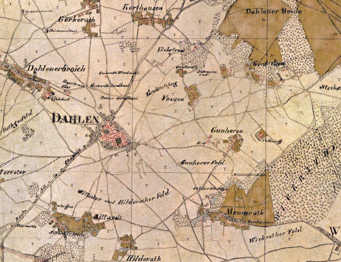
Mayoralty and Map
Dalen first appears in the written record in 861 as a village in the Mühlgau, an estate that belonged to the Bishopric of Liège. Six years later it shows up as Dalon in a deed exchange by King Lothair II, though scholars now think that document actually refers to Spangdahlem near Prüm in the Eifel, not to Rheindahlen at all. The town received Nideggen town rights in 1354 and remained an independent mayoralty for the next 567 years. Its borders covered a sprawl of hamlets, villages and Honschaften with names like Genhülsen, Wolfsittard, Mennrath, Voosen, Wyenhütt, and isolated farms and water mills like the Knippertzmühle and the Vollmühle. On 18 July 1921, after lobbying by the lord mayor of Gladbach, Hermann Piecq, Rheindahlen was incorporated into M.-Gladbach, losing its independence after almost six centuries.
JHQ Rheindahlen
In the early 1950s, looking for a site to consolidate British forces in West Germany, the Western Allies chose the Hardt Forest just northwest of Rheindahlen. The construction in 1954 turned up the Roman settlement; the resulting facility, JHQ Rheindahlen (Joint Headquarters), became the British Army of the Rhine and Royal Air Force Germany headquarters and at its peak housed thousands of British servicemen and their families in a self-contained town with its own schools, shops, churches and cinemas. For sixty years a small piece of Britain operated quietly in the German countryside. JHQ Rheindahlen closed in 2013 as part of the British withdrawal from Germany, and the site has been gradually returned to civilian use, much of it demolished. The old garrison is one of the strangest layers of a town that has been accumulating layers since before there were words for any of them.
Mining Under the Surface
The land around Rheindahlen sits at the western edge of the Lower Rhine Bay, where loess deposits up to ten metres thick from the last ice age cover gravel, sand and the lignite seams that run down to the Tertiary period bedrock. Some of those seams are 150 metres thick. The Garzweiler open-cast mine, just southeast of the town, pulls them up by the train-load, and its drainage operations have lowered the local water table enough to trigger movement on the otherwise inactive Rheindahlen Fault, running east-west from JHQ Rheindahlen across to Rheydt. The result has been measurable ground subsidence: cracks in walls, doors that no longer close, foundations that settle. The town that grew up in a slight hollow is now slowly being shaped, again, by the geology beneath it, only this time the geology is being moved by people.
From the Air
51.1503 N, 6.3617 E. Rheindahlen lies about 7.5 km southwest of the Mönchengladbach city centre, on the gentle slope of the Mönchengladbach loam plain. From altitude look for the small town surrounded by agricultural fields, with the Hardt Forest immediately to the north (which until 2013 contained JHQ Rheindahlen) and the vast scar of the Garzweiler open-cast lignite mine to the southeast. Düsseldorf (EDDL) is 28 km east-northeast. Mönchengladbach airfield (EDLN) is 9 km northeast. The Dutch border is 20 km west.
Nearby Stories
- Kunstmuseen Krefeld 3.9 km away
- Krupp Decoy Site 4.8 km away
- Doppelkirche Schwarzrheindorf 8.1 km away
- Hombourg, Belgium 9.5 km away
- Unterburg trolleybus turntable 12 km away
- Wessem-Nederweert Canal 13 km away
- Schevenhutte Quarry 13 km away
- Ysselsteyn German War Cemetery 17 km away