Wessem-Nederweert Canal
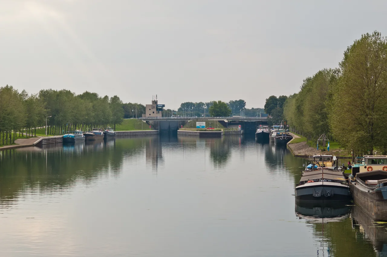
From a small aircraft on a clear day you can see the trick. The Panheel Lock sits at the eastern end of the Wessem-Nederweert Canal, near where it joins the Maas, and from the air it looks like an exclamation mark laid sideways - the lock chamber in the middle, flanked by two long rectangular ponds that look like swimming pools next to a hotel. Those are the storage basins. They were designed in 1917 to recycle water when boats pass through the lock, so the canal would not drain itself dry in summer when Belgium was already taking most of the Meuse's flow for irrigation upstream. They cut the lock's water consumption by sixty per cent. It is the kind of detail that defines a working canal: nobody who is not a boat captain or a hydrographer cares, but everything else depends on it.
Why Dig a Canal Here at All
By the early 1900s the Dutch had finally figured out how to mine the South Limburg coalfields - the long groundwater problem solved, production rising from 1893 onward - and immediately ran into the next problem. Limburg coal was expensive to move. The Meuse was shallow and unreliable; rail was the only alternative, and rail was costly. Meanwhile German coal sailed cheaply down the Rhine to the economic heart of the Netherlands in vast Rhine barges, and arrived for less than Dutch coal could. To compete, Limburg needed water. A plan was drawn up in 1913 for a lateral canal between Maastricht and Maasbracht - what would eventually become the Juliana Canal - and in 1914 the government considered a connecting canal that would link Maasbracht north to the Zuid-Willemsvaart. The smaller, simpler variant won: a 17-kilometre canal from Wessem on the Maas across to Nederweert, where it would meet the existing Zuid-Willemsvaart. The route from Maasbracht to Tilburg would shrink from 220 kilometres to 90.
The Dig
Designed in 1917, with a law for compulsory purchase that already accounted for a future expansion to 2,000-ton ships, the canal went onto the government books and the preliminary work began in 1918. The actual digging started in 1925. Three years later, on 2 April 1928, the Wessem-Nederweert Canal opened for shipping. It is 17 kilometres long, 30 to 50 metres wide at the surface, 2.5 metres deep. Nine bridges cross it, most with about five metres of air draft. The Panheel Lock - now a double lock, the original 1928 chamber sitting beside a larger one built in the 1980s - is the only lock on the entire canal. The water-saving basins beside it produce that unmistakable aerial silhouette. Maximum ship size today is 96 metres long, 9.5 metres wide, drawing 2.1 metres - the European inland-waterway CEMT class IV standard.
A National Artery, Almost Immediately
The canal got busy fast. When the canalised Meuse between Maasbracht and Grave opened in October 1929, the Wessem-Nederweert Canal suddenly became the short cut for traffic that had traditionally run the long way round on the Zuid-Willemsvaart between 's-Hertogenbosch and Maastricht. Skippers rerouted. The new Maas-Waal Canal, which had opened in October 1927 connecting the Rhine to the Meuse near the German border, fed more traffic in: coal barges from the Ruhr started using the Wessem-Nederweert as part of routes nobody had imagined. Traffic on the Maas-Waal Canal jumped from 5,000 ships in 1928 to 24,000 in the crisis year 1931. The original purpose - moving Limburg coal - was slower to materialise. The Maasbracht coal trestle, where rail cars could tip their loads into waiting barges, only came into use in July 1929, after a tangle of contracts between the financially struggling national railways and the state-owned mines. By 1965 the Wessem-Nederweert was busier than any part of the Zuid-Willemsvaart it was supposed to supplement.
Bridges Destroyed, Then Rebuilt
During the German invasion of the Netherlands in May 1940, every bridge on the canal was destroyed. The Panheel Lock and Lock 15 at Nederweert were damaged. By September the canal was open for navigation again. In November 1944 the western Allies crossed the canal at several points as part of the broader push that would liberate the southern Netherlands. After the war, the gravel industry along the Meuse exploded - the post-war concrete boom needed enormous quantities of aggregate for rebuilding - and the canal became a key gravel artery alongside its older coal role. A 1966 modernisation plan to take the canal up to 600-ton and occasionally 1,350-ton ships was drafted. A more ambitious 1982 upgrade to CEMT class IV with a new larger Panheel Lock began with the new lock chamber in April 1986, was halted in 1987 by government cuts, restarted in 1990 when Minister Hanja Maij-Weggen pushed water transport as an environmental priority, and the new lock was finished in 1992 - but only part of the original deepening plan was ever executed.
The Quiet Backbone
Today the Wessem-Nederweert Canal does the work most working canals do: moves bulk cargo, mostly gravel and aggregates, without ceremony. A new and higher Schoorbrug opened in 2008. In 2016 the Limburg provincial government and Rijkswaterstaat reached an initial agreement on replacing the Kelperbrug with a higher span that would let larger push-barges through. It is not a spectacular waterway. There are no famous lockmasters, no celebrated bridges. The Panheel Lock with its two water-saving basins is the closest thing to a landmark. But for a hundred years it has done exactly the thing it was built to do: it has carried what the region needed carried, between the Meuse and the heart of North Brabant, day after day, with the steady patience that infrastructure rewards.
From the Air
The canal runs roughly east-west from Wessem on the Maas (51.16 N, 5.89 E) to Nederweert (51.28 N, 5.74 E), a straight 17-kilometre cut through the flat farmland of central Limburg. The Panheel Lock with its distinctive twin water-saving basins is at the eastern end near the Maas junction. From altitude, the canal appears as a perfectly straight line linking the curving Maas to the larger Zuid-Willemsvaart. Nearest airports: Eindhoven (EHEH) 35 km north-west, Maastricht-Aachen (EHBK) 30 km south, Niederrhein/Weeze (EDLV) 50 km north-east.
Nearby Stories
- Dülken 1.4 km away
- Raceway Venray 5.6 km away
- Mechelen Incident 6 km away
- Siege of Julich (1621-1622) 6.2 km away
- Battle of Halen 12 km away
- SCK CEN 13 km away
- Roadburn Festival 14 km away
- Vetera 18 km away