Schevenhutte Quarry
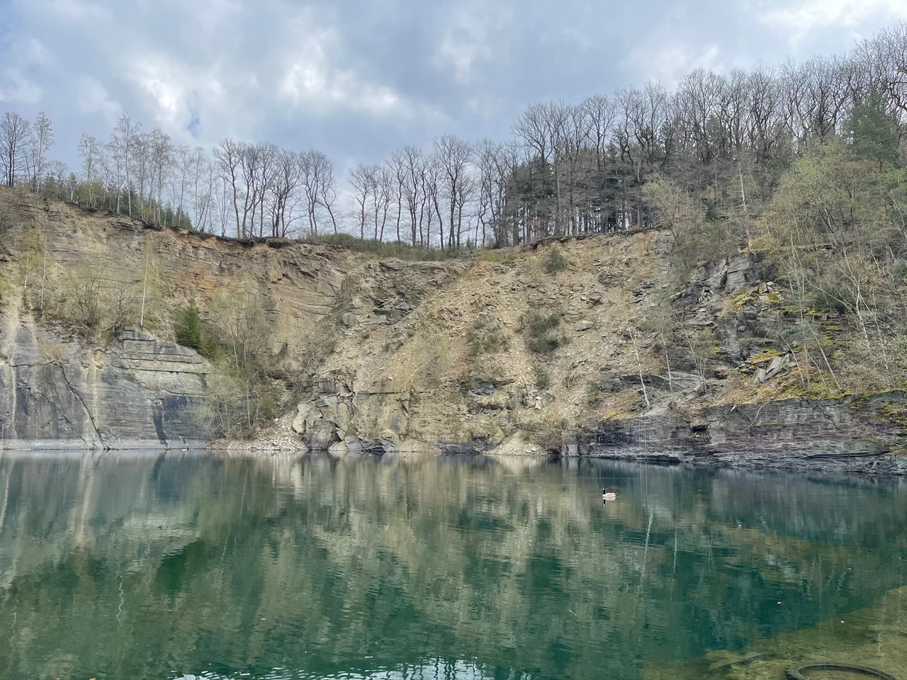
The bottom of the quarry is a lake now. Groundwater fills the pit where bucket-wheel pumps used to keep it dry, and on the eastern wall, forty meters high and unsupported since 2008, the rock is tilting outward in great wedges, dropping into the water in landslides that shake the village of Schevenhutte. The stone here is the oldest in North Rhine-Westphalia - 490 million years, dated by the fossil graptolite Dictyonema flabelliforme - and it is finally being allowed to behave like rock again.
Older Than Everything
The Schevenhutte quarry sits on the northern edge of the Eifel, at the southern end of the village of Schevenhutte in the borough of Stolberg, in a tight bend of the Wehebach stream. Geologically, this is the easternmost knuckle of the Ardennes - specifically the Stavelot-Venn saddle, an anticlinorium where layers of the lowest Ordovician period have been pushed close enough to the surface to be dug. These are the Salm rocks: clay-banded siltstones and shales laid down on a shallow marine delta platform when the part of Earth's crust that would become Belgium and Germany was still a low-lying coast somewhere south of the equator. They were folded by the Caledonian mountain-building event in the Silurian, folded again by the Variscan event in the Carboniferous, and have sat here ever since, the bones of a vanished sea showing through the surface of the modern Rhineland.
Two Colors of Stone
What made Schevenhutte stone commercially interesting was that two different varieties were exposed in roughly horizontal layers, easy to extract in large slabs. The greener variant is the Tonschiefer, a clay-banded siltstone that splits cleanly and was used for pavement slabs, dry-stone walls, and irregular building masonry. The deeper red Banderschiefer is more clayey, colored by manganese oxide and hematite that settled from submarine volcanic eruptions ages ago. Sandstone beds run through both varieties as turbidite layers - underwater landslides frozen in stone, with ripple structures and convolute bedding still visible on the surfaces. The two stones are both called Schevenhutter Schiefer, and across the surrounding region they show up as flagstones, gravestones, and the walls of farmhouses, where they have weathered to a particular dark-brown skin from the carbonate content.
Two Centuries of Cutting
The Tranchot Map, drawn by the French around 1805, already shows a quarry in this spot. By the mid-nineteenth century the quarry was supplying the foundation stones for a forester's lodge built in 1852 near Helenasruh. Around 1890 so much material was extracted to build the parish church in Schevenhutte that two smaller pits merged into a single working. Slabs were being shipped as far as the Aachen district of Rothe Erde by the late 1890s, hauled out by a tenant operating with two stable hands and two horses. In 1911 the Stolberg industrialist Hans Prym bought the surrounding forest and with it the quarry. After a wartime pause it restarted around 1935 under a new tenant employing fifteen workers. Overburden from the quarry was used as roadbed by Wehrmacht pioneers building the Düren road as part of the Westwall - the same fortification line that would feature in the Hurtgen Forest battle a few years later. Quarrying stalled again around 1940. Under Kaspar Müller from the 1950s onward the operation industrialized, employing up to sixty workers in the 1960s and pulling six to nine hundred tons of stone out per month.
What Happens When You Stop
Production ended in 2008, the last stocks were sold off by mid-2012, and then the site was simply abandoned. No renaturalization was carried out. No slope stabilization. The dewatering pump was switched off, and groundwater began filling the pit until a small endorheic lake threatened to spill down the hillside; the lake had to be pumped back out and drained into the Wehebach. The buildings stayed where they were. Vandalism followed. Equipment was hurled into the new lake, leaching oil into what was becoming a habitat - shallow reedy margins where toads settled in, dry warm rocks favored by grass snakes, the open water used by ducks and migrating geese. An eagle owl moved in for a few years before being driven off by repeated human disturbance. The site is fenced now, and entering it is forbidden, because the rock is on the move.
Blasting the East Wall
The eastern face of the quarry, the most dramatic feature on the site, became a serious hazard within years of closure. Without supporting rock at its base, a slab forty meters tall began tilting outward; a crack five to six meters wide and sixty meters long opened along the top, deep enough to show up on the digital terrain model at one-meter resolution. The bloc held through the catastrophic flood of July 2021, but the Cologne district government decided not to wait for it to fall by itself. The lake was pumped dry, a flood-protection dam was raised, and the wall was blasted as a precaution in the summer of 2021. The explosion was felt throughout the village. Since then smaller wedges have continued to slip - two blocks at the northwest edge, each four meters by three, have already sunk centimeters from their original height and are surrounded by fissures meters deep. The quarry is now a registered soil heritage site of the Kupferstadt Stolberg because of its value for teaching and research, but it is also, slowly and unpredictably, taking itself apart.
From the Air
The Schevenhutte quarry sits at 50.76N, 6.33E, on the northern edge of the Eifel uplands about 12 km southeast of central Aachen, near the village of Schevenhutte in the borough of Stolberg. Recommended viewing altitude is 2,000-3,000 ft AGL to see the open pit, the flooded basin in the center, and the high east wall. The Wehebach stream runs to the north. Nearest airports are Maastricht Aachen (EHBK) about 17 nm northwest, Liege (EBLG) about 24 nm west, and Cologne Bonn (EDDK) about 35 nm east. The Hurtgen Forest battlefield lies just a few kilometers to the south.
Nearby Stories
- Federal Ministry of Defence (Germany) 1.7 km away
- Hombourg, Belgium 4.1 km away
- Düren-Neuss railway 14 km away
- Maaseik 19 km away
- Unterburg trolleybus turntable 20 km away
- Marcinelle Mining Disaster 109 km away
- Basilica of Saint-Pierre-aux-Nonnains 150 km away
- Zwingenberg Castle 183 km away