Hoge Kempen National Park
Belgium has exactly one national park, and it is built on top of a closed coal mine. Hoge Kempen opened on Sunday 29 March 2006 in the eastern corner of Belgian Limburg, sixty-seven square kilometres of heathland, pine forest, sandy dunes and old gravel pits stitched together with eco-ducts over a motorway. The Goldman Environmental Prize - sometimes called the Green Nobel - went in 2008 to the project manager who put it together, Ignace Schops, for the unusual idea that a densely populated industrial region might decide what came after industry, instead of letting industry's leftovers decide for it.
After the Pits
The country east of Genk used to be the heart of the Belgian Limburg coalfield. When the pits closed in the late twentieth century they left what closed pits always leave: spoil heaps, abandoned shafts, gravel quarries flooded into mirror-blue lakes, sand pits dug for the white sand used in glassmaking. They left ground nobody quite knew what to do with. The Regionaal Landschap Kempen en Maasland - a regional landscape agency formed in 1990 - made the case that this in-between land was not waste at all. The heathland that had once stretched across the Campine was older than the mines and could come back. The pine plantations were already there. The flooded gravel pits made habitat for dragonflies and amphibians. In 1990 the RLKM began the slow work, and on 29 March 2006 the national park designation arrived, the first and so far only one in Flanders.
The Step on the Plateau
The geography here is older than coal. During the last ice age the Meuse - the Maas, in Dutch - dropped rocks scoured from the Ardennes across this corner of Limburg, and sea winds blew sand over them, building what geologists call the Kempens Plateau. The Grensmaas, the border Meuse, later cut a deep valley alongside, and the western edge of the plateau drops 45 metres in a sharp step that runs twenty kilometres from Opoeteren near Lanaken in the north down to Gellik in the south. More than half of that step lies inside the park. The highest ground reaches 102 metres - modest in absolute terms, but in the topographic context of Flanders, this is mountain country. The plateau watershed divides the basin of the Meuse to the east from the basin of the Demer to the west, which drains most of Belgian Limburg.
Heather, Frogs and Smooth Snakes
Walk into Mechelse Heide on a late August afternoon and the whole horizon turns purple. Bell heather, ling, gorse in bright yellow patches, juniper bushes black against the sand. The list of resident species reads like a field guide to species that have lost ground almost everywhere else: smooth snake, common lizard, natterjack toad, moor frog, brook lamprey in the streams, the silver-studded blue and swallowtail and Granville fritillary butterflies, black woodpeckers drumming in the pines. Roe deer slip between the trunks. Nightjars churr at dusk. The pine forest is not native - it was planted, like most pine forest in this part of Europe, partly to stabilise sand and partly for mine timbers - but the heathland is what the heath was before. The Flemish government today owns about 85 per cent of the park's land.
Six Gates, One Cycle Network
There is no single entrance to Hoge Kempen. Each of the six municipalities that share the park has its own gate, themed to a local story. Connecterra at the Maasmechelen-Dilsen-Stokkem border is the main gate. Kattevennen in Genk has a Cosmodrome and takes the cosmos as its theme. Mechelse Heide opens straight onto that purple horizon. Pietersheim in Lanaken sits in a Romanesque castle ruin. The Lieteberg in Zutendaal is themed on insects and built around a former gravel pit that once functioned as a queen-bee mating station. Station As, in As, has a lookout tower shaped like an old coal-pit drilling rig - the only gate that names the industry the park grew out of. Two hundred kilometres of hiking trails, 140 kilometres of bridleway, and a 1990s invention you have probably already used without knowing it: the numbered-node cycle network. Designer Hugo Bollen invented it here for the RLKM, wanting signage so simple that no information would have to be remembered, only the next number. It has since spread across most of the Low Countries and parts of Germany. The cycle network alone brings an estimated 16.5 million euros a year into the Kempen and Maasland region.
A Green Nobel and a Quiet Idea
In April 2008 Ignace Schops flew to San Francisco to accept the Goldman Environmental Prize. The citation singled out the unusual approach: not setting nature aside from people, but weaving it through agriculture, tourism, economy and existing settlement. A month later he was honoured in the European Parliament. Hoge Kempen was added to UNESCO's Tentative List of World Heritage candidates in May 2011 and the nine municipal councils, the province and the Flemish government signed letters of intent backing the application in 2012. Plans now talk about expansion to more than a hundred square kilometres. The quiet idea at the heart of it is the one Schops would not let people forget: a national park is not a place set aside from us. It is a place we agree to share.
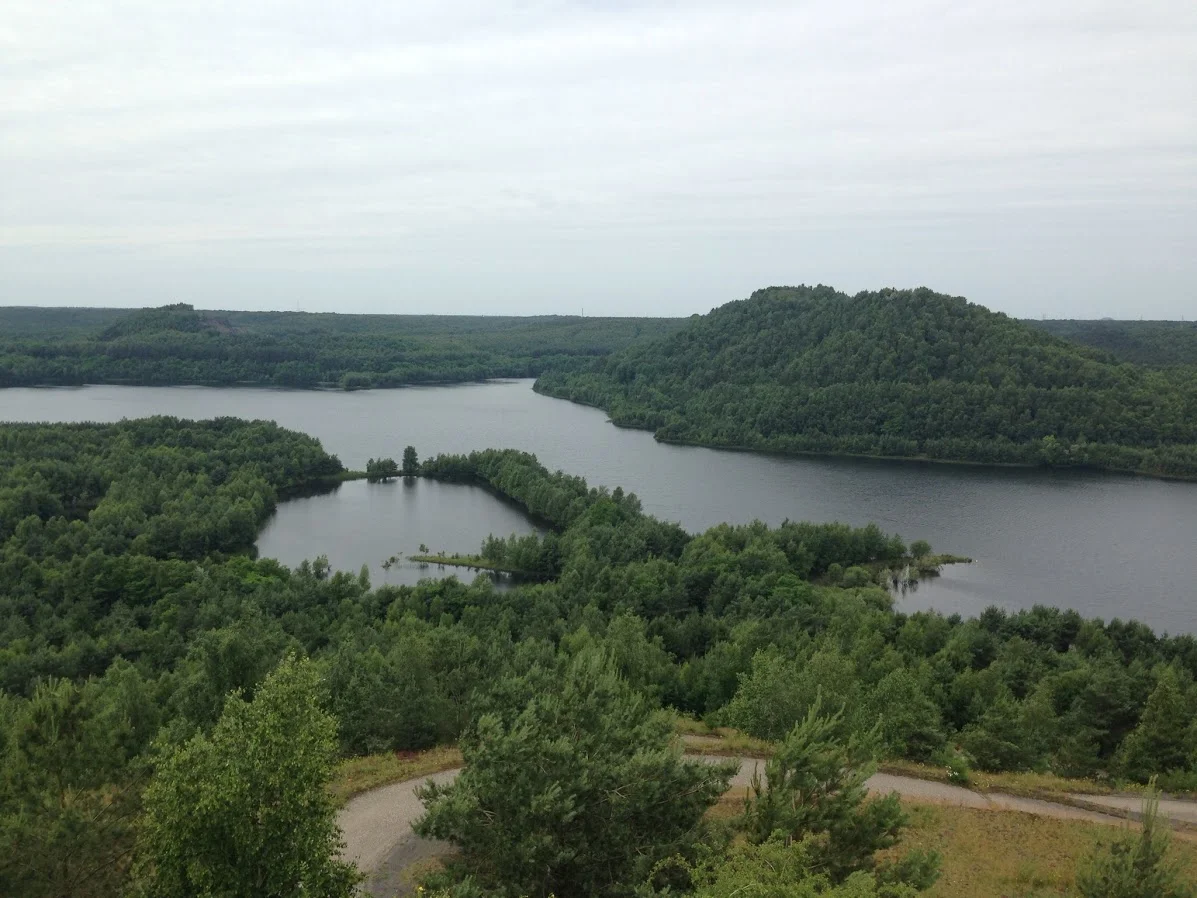
From the Air
Hoge Kempen lies in Belgian Limburg between Genk and the Dutch border, centred at roughly 51.00 N, 5.67 E. From altitude, look for the cluster of small bright lakes - the flooded gravel pits and the open water of the Maas to the east - against the mottled green and purple of pine forest and heathland. The E314 motorway slices through the park's southern half; you may pick out the Kikbeek ecoduct as a green band across it. Nearest airports: Maastricht-Aachen (EHBK) 20 km north, Liege (EBLG) 35 km south-west, Genk-Zwartberg (EBZW) general aviation field on the western edge.
Nearby Stories
- Schevenhutte Quarry 4.4 km away
- Ted Swales 5.3 km away
- Voeren 5.8 km away
- Rheindahlen 9.8 km away
- Kunstmuseen Krefeld 16 km away
- Battle of Neerwinden (1793) 16 km away
- Ysselsteyn German War Cemetery 17 km away
- Baarle-Hertog 27 km away