Gebel Adda
In 1484, someone at Gebel Adda wrote a letter. It named Joel, king of Dotawo, and listed nobles and church leaders - a fragment of the late Christian kingdom that ruled this stretch of the Nubian Nile after Dongola fell. The letter survived because the climate here preserves paper and ink for centuries. Most of the city did not survive. When the Aswan High Dam closed in the 1960s, the American Research Center in Egypt hurried through a few seasons of excavation, found Meroitic inscriptions and Old Nubian documents and painted churches, and then the water came up and covered the hilltop where a fortress-city had stood for two thousand years.
A Fortress on a Table
Gebel Adda rose from the flat plain as a steep-sided table mountain on the east bank of the Nile, about five kilometers southeast of Abu Simbel. The settlement sat on the crest, reached only by a narrow stairway that climbed through northern suburbs into a massive gate. The walls were a palimpsest: a Meroitic-period adobe enclosure buried beneath Christian and Islamic rebuildings, reinforced on the outside with an additional rubble wall in places. The houses inside were packed tight along winding streets, their walls of clay brick, their roofs built as Nubian vaults. At the highest point in the southwest, fragments of granite columns and reddish sandstone capitals marked a larger church. At least seven churches have been identified in the settlement area, most of them buried under later construction. The Old Nubian name for the place was Atwa. Medieval Arabic sources called it Daw.
The Capital of Dotawo
By the middle of the fourteenth century, control of the traditional Makurian capital at Dongola had collapsed under prolonged fighting, and the Nubian court moved north. Al-Maqrizi, the medieval Egyptian chronicler, places that move around 1364-65. Many scholars identify the new capital Daw with Gebel Adda. From the late Christian period into the sixteenth century, Faras, Qasr Ibrim, and Gebel Adda were the three largest fortified cities of Lower Nubia. The kingdom of Dotawo is known mainly from inscriptions at Gebel Adda and Qasr Ibrim. In the 13th century, Mamluk raids reached this far south; one battle was fought at Gebel Adda on Sultan Baibars I's route to depose the Makurian king David at Dongola in 1276. In 1364 the Makurian rulers, with Egyptian help, won a victory here against nomadic insurgents. The mountain fortress became their retreat, the place from which they ruled what was left of their empire.
Last to Empty
In the 1560s, the Ottomans established a garrison at Qasr Ibrim and on the island of Saï. By conventional reckoning, Dotawo had already disappeared. But Gebel Adda did not. It remained inhabited throughout the Turkish period until the later 18th century, when its population migrated across the Nile to Ballana - a slow abandonment, not a conquest, the last resident Nubians leaving a stone city whose foundations reached back to Meroe. Nineteenth-century European travelers described the hill and its ruins. Anton von Prokesch-Osten counted seventy small burial mounds at the foot of the mountain that locals believed were tombs of Islamic martyrs who had died conquering the Christians. Whether that tradition reflects real events or later folklore is unclear. What is clear is that Gebel Adda was one of the longest continuously occupied sites in Nubia - from the second century AD to the eighteenth, nearly every period leaving its layer.
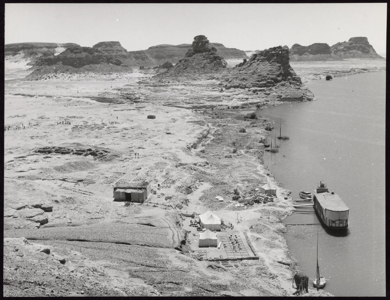
A Dig Against the Clock
The American Research Center in Egypt, under Nicholas B. Millet, ran four campaigns at Gebel Adda between 1962 and 1965, each December to April, as the dam rose. They recovered pottery, Meroitic funerary stelae, metalwork, a Ba-statue, an inscribed stele with a Greek magical text, Islamic bowls. Most of the excavated material went to the Royal Ontario Museum in Toronto, where much of it remains unpublished. The rock temple of Horemheb at nearby Abu Oda, built by that pharaoh around 1319-1292 BCE, had been partly converted into a Christian church with frescoes of Saint George over the baptismal font. Parts of the chapel were cut out of the rock and relocated near the rescued Temple of Abu Simbel. The rest stayed in place, underwater now. From the air, where Gebel Adda was, there is only the blue of Lake Nasser and the dark shore of what remains of the east bank. A whole city's history sits beneath those waves, mostly still unread.
From the Air
Original coordinates 22.30°N, 31.64°E, now submerged beneath Lake Nasser on the east bank of the former Nile channel, five kilometers southeast of Abu Simbel. Nearest airports: Abu Simbel (HEBL) in Egypt, Wadi Halfa (HSSW) in Sudan. Recommended viewing altitude 10,000-15,000 feet to appreciate the relocated Abu Simbel temples and the vast reservoir covering Nubia.
Nearby Stories
- Buhen 20 km away
- Qasr Ibrim 57 km away
- Kulb 105 km away
- Kulubnarti 135 km away
- Temple of Dendur 139 km away
- Bi'r Tawīl 180 km away
- Bir Tawil 184 km away
- Kharga Oasis 308 km away