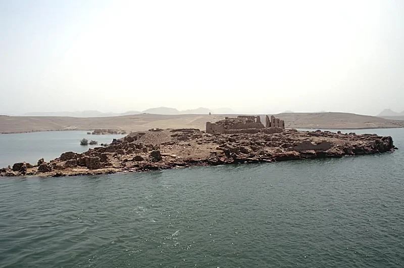

Qasr Ibrim
Everything else drowned. When the Aswan High Dam closed and Lake Nasser climbed up the valley walls in the 1960s, it swallowed the temples, the forts, the cemeteries, and the villages of Lower Nubia whole. Qasr Ibrim alone stayed dry. For more than two thousand years it had stood on a sandstone cliff nearly seventy meters above the Nile, the strongest fortress in the valley; now the rising reservoir lapped at its base and turned the headland into an island. It is the only major archaeological site in all of Lower Nubia that was neither moved to higher ground nor lost beneath the water. The siege the dam laid is the one it survived.
The Survivor's Archive
What makes Qasr Ibrim extraordinary is not just that it endured, but what endurance preserved. For most of human history the Nubian desert simply did not rain, and the cliff sat far above the floods, so things that rot everywhere else here did not. Archaeologists have pulled sandals and leather from the ground, scraps of textile, and seeds of sorghum so well kept that researchers extracted ancient DNA from grain up to 2,800 years old. The crops tell their own long story: the ground preserves emmer wheat, barley, and flax from the Napatan and Roman periods, and the slow arrival of cultivated sorghum, which appears in ever more advanced forms from around AD 100 onward. Above all, there are the words. Qasr Ibrim has yielded the largest collection of Old Nubian documents ever found, a written record spanning more than a thousand years, including the official correspondence of the eparch who governed the medieval kingdom of Nobatia from this rock. Earlier texts were written on papyrus, with parchment reserved for religious works, and paper did not become common in Nubia until the twelfth century. Where other sites left stone, Qasr Ibrim left handwriting.
Layers of Rulers
Occupation here is measured not in centuries but in civilizations stacked one atop another. Egyptians, Kushites, and Romans all held the cliff. Around 23 BC, Roman military engineers working under the prefect Gaius Petronius rebuilt the fortress during the reign of Augustus, and for a time it anchored Rome's southern frontier. Christianity arrived, and a cathedral rose; the Taharqa Church, likely built between 542 and 580, ranks among the earliest churches in Nubia, raised inside the walls of older temples. Later, the cathedral itself was repurposed as a mosque. Each new power did not erase the last so much as build on it, leaving the headland a vertical timeline of who ruled this stretch of river and when.
The Last Defenders
The story of Qasr Ibrim closes with gunfire. The cliff stayed inhabited until 1813, when its final occupants were driven out by artillery, ending an unbroken run of human life that reached back to the eighth century BC. By then the place had been many things: a city, a pilgrimage destination, a garrison, a trading hub at the meeting point of the Mediterranean and African worlds. The personal letters found in its ground, the records of debts and harvests and devotion, show a frontier society that traded, prayed, and argued like any other. They were not symbols of a lost world. They were people, keeping accounts.
A Closed Island
Today no tour boat docks at Qasr Ibrim. The island is closed to everyone but archaeologists, who have returned to dig periodically since the Egypt Exploration Society resumed work here in 1963, continuing a study first begun by a University of Pennsylvania expedition in 1911. Lake Nasser has done something cruel and useful at once: by drowning the outskirts it sealed the site away from looting and casual visitors, even as it slowly eroded the lower slopes. Cruise ships pass it on the run to Abu Simbel, and passengers see a stark brown citadel rising from blue water, looking for all the world like it was always an island. It was not. It is a mountaintop that refused to disappear.
From the Air
Located at 22.65 N, 31.99 E on the east side of Lake Nasser, roughly 60 km north of Abu Simbel and about 240 km south of Aswan in Egyptian Lower Nubia. Nearest airports: Abu Simbel Airport (ICAO HEBL), a single 2,000-meter runway serving Cairo and Aswan flights, and Aswan International Airport (ICAO HESN) to the north. From the air the site reads as an isolated brown headland surrounded entirely by the reservoir; the cliff once stood high above a river valley now filled by water. Clear desert skies and high visibility are the norm year-round, with summer heat haze possible at midday.
Nearby Stories
- Nabta Playa 11 km away
- Dotawo 19 km away
- Buhen 75 km away
- Temple of Dendur 86 km away
- Bi'r Tawīl 152 km away
- Aswan Dam 163 km away
- Philae temple complex 170 km away
- Kharga Oasis 277 km away