General George S. Patton Memorial Museum
The Chiriaco Summit exit of Interstate 10, thirty miles east of Indio at 1,000 feet elevation, does not look like a place that changed the course of World War II. There is a gas station, a small diner, and a modest museum that would be easy to pass at highway speed. But in March 1942, when the War Department ordered the creation of a desert training center here, this remote stretch of California became the center of the largest military mobilization exercise in American history. Over a million American soldiers trained in these desert mountains and valleys before deploying to North Africa and beyond. The General George S. Patton Memorial Museum commemorates that training ground and the general who commanded it.
The Largest Training Ground Ever
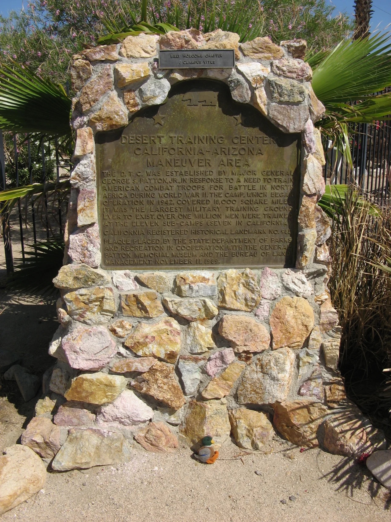
The Desert Training Center, later renamed the California-Arizona Maneuver Area, covered 18,000 square miles at its maximum extent — the largest military training ground ever to exist anywhere in the world. It stretched across seven sub-camps in California and four in Arizona, encompassing desert terrain that ranged from the flat agricultural lowlands of the Imperial Valley to the rugged mountain ranges east of the Salton Sea. Camp Young, at Chiriaco Summit, served as the headquarters and the logistical center of the operation. General Patton, who commanded the training center from its establishment in March 1942, chose the location precisely because the terrain resembled the North African desert where American forces would eventually fight against Rommel's Afrika Korps. His philosophy was straightforward: train in conditions as close as possible to those of actual combat.
Patton's Desert School
George S. Patton was already a general officer with considerable military experience when he was assigned to create the Desert Training Center. He had studied desert warfare carefully and believed that physical toughness, gained through genuine hardship, was the foundation of effective soldiering. The training at Camp Young and its satellite camps was deliberately severe. Soldiers marched in summer heat that regularly exceeded 115 degrees. Water was rationed. The exercises were conducted at scales that approximated actual combat operations rather than the smaller maneuvers that characterized most peacetime training. Patton moved on to command other operations before the Desert Training Center reached its full scale, but the institution he created continued functioning under subsequent commanders until it was closed in April 1944.
Shavers Army Airfield
The Desert Training Center's ground operations were supported by Shavers Army Airfield, which opened in April 1943 to provide air support training and coordination exercises. The airfield added a dimension to the training that reflected the increasingly joint nature of modern warfare — the integration of air and ground forces that the Allied campaigns in North Africa and the Pacific were demonstrating was essential to success. After the training center closed in April 1944, the airfield continued operating for a time as Desert Center Army Air Field, serving as a B-24 Liberator training base in the final years of the war. The facility was eventually decommissioned and returned to civilian use, though its outlines remain visible in the desert landscape east of Chiriaco Summit.
The Museum at the Summit
The General George S. Patton Memorial Museum opened at Chiriaco Summit to preserve the memory of the Desert Training Center and to display the equipment, photographs, and documents that tell the story of over a million men who trained in these mountains and valleys. The museum holds California Historical Landmark No. 985, designating the site as significant to the state's history. The collection includes tanks, vehicles, and artillery pieces that represent the equipment of World War II desert warfare. Outside, the desert that Patton chose for its severity — the heat, the aridity, the distances, the terrain that stripped away comfort and forced soldiers to discover whether they were capable of endurance — remains exactly as he found it. The training center is gone, but the desert that made the training meaningful is unchanged.
From the Air
The General George S. Patton Memorial Museum is located at approximately 33.662°N, 115.722°W at the Chiriaco Summit exit of Interstate 10, 30 miles east of Indio. The museum and adjacent Chiriaco Summit Airport (L77) are visible from altitude as a small cluster of buildings at a highway interchange. The broad desert valleys and mountain ranges that constituted the Desert Training Center extend in all directions. Palm Springs and the Coachella Valley are visible to the west. The Salton Sea is visible to the south.
Nearby Stories
- Philip L. Boyd Deep Canyon Desert Research Center 4.4 km away
- Salton Sink 7.3 km away
- Cabot's Pueblo Museum 11 km away
- Pinto Mountains 13 km away
- Hot Springs Mountain 22 km away
- Poston War Relocation Center 84 km away
- Old Plank Road 87 km away
- Felicity, California 114 km away