
Hellespontine Phrygia
The Pharnacid dynasty did not set out to make history. They were administrators, appointed by a distant king in Persepolis to manage a strategic wedge of northwestern Anatolia that lay directly southeast of the Hellespont — the narrow strait where Europe and Asia nearly touch. Yet for nearly 150 years, this hereditary Persian family governed Hellespontine Phrygia with such continuity and skill that their names echo across Greek and Persian sources alike. Satrapy and dynasty became almost synonymous. Then Alexander arrived, and everything changed.
A Province on the Edge of Two Worlds
Hellespontine Phrygia — also called Lesser Phrygia — occupied one of the most strategically charged pieces of real estate in the ancient world. Southeast of the Hellespont and northwest of the Anatolian heartland, it controlled overland and maritime routes between Europe and the Persian interior. Its capital, Dascylium, sat near the southern shore of Lake Manyas in what is now northwestern Turkey. The satrapy was created in the early fifth century BC as the Achaemenid Empire reorganized its western territories, recognizing that the Hellespont corridor was too valuable to leave loosely administered.
The first Achaemenid satrap, Mitrobates, was appointed around 525–522 BC by Cyrus the Great himself and continued under Cambyses. His reign ended violently: he was killed and his territory absorbed by the satrap of neighboring Lydia, Oroetes. The upheaval was brief. Darius I reorganized and stabilized the region, and from around 493 BC onwards a more durable order took hold.
The Long Reign of the Pharnacids
Artabazus became satrap around 479 BC, founding what scholars call the Pharnacid dynasty — a lineage of Persian governors that would endure, with only brief interruptions, until Alexander's conquests a century and a half later. The Pharnacids were not merely administrators; they were political operators of the first order. Pharnabazus II, who governed from before 413 BC to 387 BC, sparred diplomatically with Sparta, negotiated with Athens, and hosted Alcibiades — one of the most colorful figures of the classical Greek world — before eventually handing him over to be killed. These were men who understood that ruling the Hellespont corridor meant managing the ambitions of every major power in the Aegean.
The satrapy endured a rebellion under Ariobarzanes of Phrygia in the 360s BC, and Artabazos II spent years in exile at the Macedonian court — an irony history would not forget. Through it all, Dascylium remained the seat of power, a provincial capital now slowly emerging from excavations on its ancient mound.
Alexander at the Gates
In 334 BC, Alexander the Great crossed the Hellespont with his army, beginning the campaign that would dismantle the Achaemenid Empire within a decade. He dispatched his general Parmenion to secure Dascylium — the provincial capital — while he engaged Persian forces elsewhere. The satrapy fell without a major battle at its capital.
What followed was revealing. Alexander appointed a Macedonian general named Calas to govern Hellespontine Phrygia, but awarded him the Persian title of "satrap" rather than a Macedonian one. He also instructed Calas to collect the same tribute from his subjects that Darius III had collected. The Macedonian conqueror, it turned out, was not dismantling the Persian administrative system — he was inheriting it. The province continued to function, with a new name at the top and the same ancient machinery running beneath.
After Alexander: The Province in Play
Alexander's death in 323 BC set off a long struggle among his generals — the Wars of the Diadochi — and Hellespontine Phrygia became a prize passed between competing hands. The satrapy was initially awarded to Leonnatus, who was killed in action during the Lamian War almost immediately. Lysimachus then seized the region, incorporating it into his expanding domain in western Anatolia.
After the Battle of Corupedium in 281 BC, Lysimachus himself fell, and the region passed into the Seleucid Empire. It was eventually absorbed into the Kingdom of Bithynia. The old name — Hellespontine Phrygia — gradually faded from administrative use, even as the landscape it described remained as strategically vital as ever. The waters of the Hellespont still linked the Black Sea to the Aegean; the roads through this corridor still connected continents. Only the governors changed.
What Survives
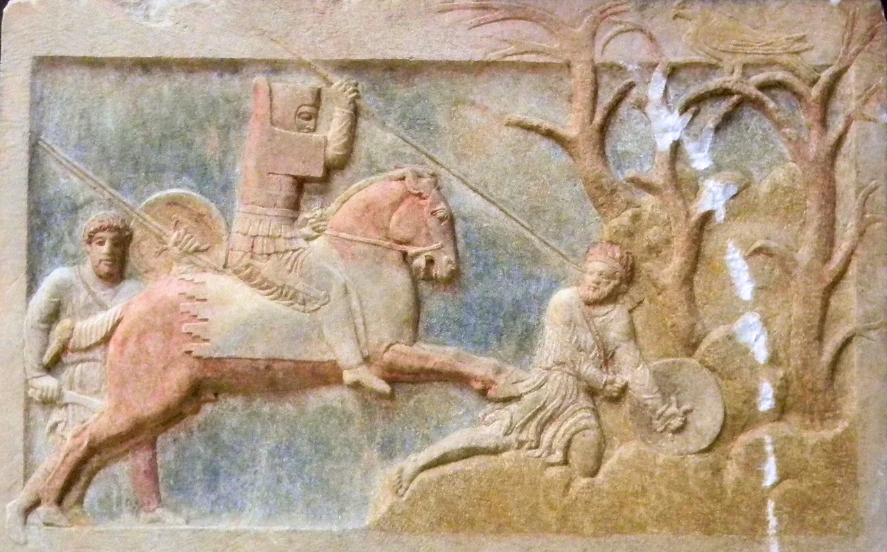
Physical traces of Hellespontine Phrygia are sparse but evocative. The Altıkulaç Sarcophagus, carved in the early fourth century BC in a style blending Persian and Greek aesthetics, depicts a dynast of this satrapy in combat — a Pharnacid lord rendered in stone, preserved now in the Troy Museum near Çanakkale. Dascylium itself, the provincial capital, has been under archaeological excavation for decades; in 2021, a relief was uncovered there depicting Greek soldiers trampled by Persian war-horses, a scene that might have come straight from the satrapy's turbulent history.
The rest lives in the written record: satrap lists, Greek diplomatic dispatches, Persian inscriptions, and the accounts of historians like Thucydides and Diodorus Siculus. Hellespontine Phrygia left no grand ruins on the scale of Persepolis or Athens, but it shaped the course of events at the precise hinge where two worlds met.
From the Air
Hellespontine Phrygia centered on the region around 40.13°N, 28.07°E in northwestern Turkey, anchored historically by Dascylium near Lake Manyas (Kuş Gölü). The nearest airport is LTBG (Bandırma Airport), roughly 20 km to the northwest. At 5,000–8,000 feet, the shallow lake and its surrounding lowlands are plainly visible, as is the mounded archaeological site of Dascylium at the lake's southern edge. The Sea of Marmara glints to the north. The Hellespont (Dardanelles Strait) — the province's defining geographic feature — lies approximately 100 km to the west-southwest.
Nearby Stories
- SS Memel / Ivan Sechenov 3.5 km away
- Kapıdağ Peninsula 8.9 km away
- Battle of the Granicus 17 km away
- Balıkesir 29 km away
- Edremit 48 km away
- Green Mosque of Bursa 51 km away
- 1509 Constantinople Earthquake 56 km away
- Antalya Museum 387 km away