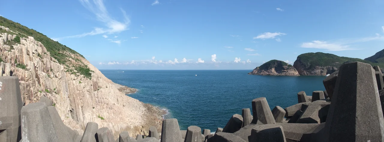

Hong Kong UNESCO Global Geopark
In 2024, geologists announced that dinosaur bones had been found embedded in a Cretaceous-era rock on Port Island, in the northeastern waters of Hong Kong. It was the territory's first dinosaur fossil discovery. The rock in which they were found is part of a formation that had been right there, accessible by boat, for anyone to look at — inside one of the most geologically rich protected areas in Asia. The Hong Kong UNESCO Global Geopark was not waiting to be discovered. It had been waiting, more precisely, for someone to look more carefully.
From Study to Inauguration
The story of the geopark begins in 2008, when the Hong Kong government commissioned a feasibility study to identify areas of outstanding geological significance. The study pointed to two distinct regions: the volcanic landscapes of Sai Kung in the east, and the sedimentary rock formations of the northeastern New Territories. Rather than protecting them separately, the government linked them into a single entity. On 3 November 2009, Chief Executive Donald Tsang formally inaugurated Hong Kong National Geopark. Less than two years later, on 18 September 2011, UNESCO admitted it to its Global Geoparks Network, recognizing geological heritage of international significance. The park now covers over 150 square kilometres, spanning rugged coastline, offshore islands, and inland terrain across the New Territories.
The Columns of High Island
The Sai Kung Volcanic Rock Region is the geopark's most photographed landscape. Around 140 million years ago, a supervolcano produced enormous eruptions that deposited thick layers of volcanic tuff across the area that is now eastern Hong Kong. As the deposits cooled and contracted, they fractured into columns — mostly hexagonal, sub-vertical, and strikingly regular. The columns at High Island, near the High Island Reservoir, rise from the sea and form cliff faces that look almost engineered. Some reach several metres in diameter. The Ninepin Group, a cluster of offshore islands to the east, shows columns tilted and stacked by later geological forces; individual columns there can be three metres across. Ung Kong Island Group to the southeast exhibits the same columnar jointing along steep cliff coastlines that have been sculpted by wave erosion into sea caves and arches. Walking along the East Dam of the High Island Reservoir, the columns emerge from the shoreline at eye level — close enough to press a hand against.
Four Hundred Million Years of Stone
The Northeast New Territories Sedimentary Rock Region tells a longer, slower story. The oldest rocks in Hong Kong — the Bluff Head Formation — sit at the northeastern tip of Tolo Channel and formed roughly 400 million years ago during the Devonian Period. Erosion has shaped them into forms like the Devil's Fist, a weathered sandstone feature that rises like curled fingers from the rock. Ma Shi Chau, an island accessible by a sand tombolo at low tide, holds sedimentary rocks from about 280 million years ago, with fossils of ammonites, corals, and bivalves embedded in its surface. Double Haven, a sheltered harbour in the northeast, contains deep red rocks that formed during a Tertiary period of global warming: as temperatures and humidity rose, iron in the rock oxidized — literally rusted — turning the cliffs the colour of old iron. Port Island is the same rust red, its conglomerate and siltstone stained through the same process.
Tung Ping Chau at the Edge
Tung Ping Chau is the easternmost outlying island of Hong Kong, sitting out in Mirs Bay close to the mainland Chinese coastline. Its geology is unlike anything else in the geopark: the island is almost completely flat, formed from horizontal layers of shale that stack like the tiers of a sponge cake when viewed from the sea. Wave erosion has carved its shoreline into platforms, arches, and stacks. Lai Chi Chong, on the mainland coast of the Tolo Channel, adds another geological layer: siltstone beds interbedded with volcanic tuffite — a sedimentary rock made from fine volcanic ash that settled into water — alongside black cherty mudstone formed in an oxygen-depleted environment. These black mudstone beds show slump fold structures, evidence of ancient underwater landslides that folded the layers as they slid. Put together, the two regions of the geopark span hundreds of millions of years in a territory often reduced to its skyline.
Reading the Rock
UNESCO's Global Geoparks Network designation places the Hong Kong geopark alongside sites on six continents, chosen for geological heritage that is both scientifically significant and accessible to the public. The geopark is not a wilderness reserve — it sits within a dense metropolitan region, reachable by public ferry, minibus, and hiking trail. Sharp Island in Port Shelter can be reached by small boat from Sai Kung Town in minutes. Ma Shi Chau is a short walk across tidal sands. The geopark's power is that it makes deep geological time navigable: you can arrive by MTR, take a boat to a beach, and run your fingers along the edge of a rock 280 million years old. The 2024 dinosaur fossil discovery on Port Island was a reminder that the geopark is still yielding new information. The rock is still being read.
From the Air
The Hong Kong UNESCO Global Geopark spans a broad arc from 22.36°N, 114.38°E (Sai Kung centre) to the northeastern New Territories. The Sai Kung Volcanic Rock Region's dramatic columnar cliffs are most visible along the High Island coastline and the Ninepin Group of islands to the southeast; approach from the east at 2,000–4,000 feet. The sedimentary region around Double Haven and Tung Ping Chau lies further northeast near 22.53°N, 114.44°E. The nearest major airport is Hong Kong International (VHHH), approximately 50 km to the southwest on Lantau Island. Tolo Harbour and the Chinese University campus at Ma Liu Shui are useful orientation landmarks to the west.
Nearby Stories
- Sha Chau and Lung Kwu Chau Marine Park 5.9 km away
- Wanshan Archipelago 22 km away
- Hong Kong 12 25 km away
- Second Battle of Chuenpi 27 km away
- Mount Guanyin (Dongguan) 43 km away
- Battle of Penghu 474 km away
- Penghu Air Raids 482 km away
- Checheng Fu'an Temple 592 km away